Shorebirds complete some of the most incredible migrations, but their conservation is at a crossroads in a region where coastal management is highly contested.
Introduction
Looking out the window from the plane as I approach Incheon International Airport, which serves Seoul, the views of coastal reclamation become evident before my eyes, straight coastlines where cranes are erecting high rise buildings in newly created land. These very places used to be visited by many waterbirds not long ago. South Korea became one of the four Asian tigers, maintaining exceptional economic growth rates between the 1960s and the 1990s. Not surprisingly, this country is currently one of the richest in the world. However, some of the areas that have become icons of its economic development are also important for many species, whose survival is now dwindling. Here, I present an account that brings together a group of fascinating waterbirds, migratory shorebirds, and the politics of coastal reclamation in a region critically important for them.
What are migratory shorebirds?
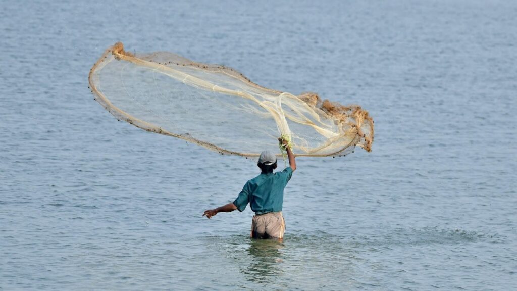
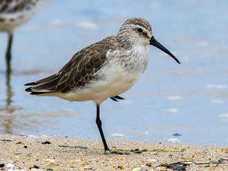
Shorebirds are amongst the ultimate globetrotters. Many of these birds are typically associated with wetlands, either inland or along coastlines. Taxonomically, they comprise over 200 species within the order Charadriiformes, which includes many familiar species such as lapwings. These birds convey an incredible story of endurance, almost unimaginable. Many of them breed at high latitudes in the northern hemisphere in the boreal and tundra regions across the entire world. These places experience inclement winters, but during summer a surfeit of sunlight and milder temperatures provide shorebirds with a surge of feeding opportunities during their breeding season. As summer finishes, these birds begin their non-breeding season migrating to lower latitudes closer to the equator and even to high latitudes in the southern hemisphere across South America, Africa, Asia, and Australasia. Then, the shorebirds fly back to their breeding grounds once the northern hemisphere summer has returned. This cycle is thus repeated yearly.
But how can shorebirds migrate such long distances? The key seems to be in physiological and behavioural traits. Prior to migration, these birds feed voraciously resulting in an excess calorie intake that is deposited subcutaneously as fat, which fuels their constant flapping during their long journeys. Additionally, they tend to fly using tailwinds, as opposed to headwinds, hence reducing energy expenditure and flight time. Other adaptations include an increase in flight muscles and a reduction of digestive functions, such as stomach atrophy. However, the maximum single flights these birds can undertake are generally not enough to cover the entire distance between their breeding and non-breeding grounds and vice versa. Therefore, shorebirds must stop to rest and refuel along the way at so-called stopover sites.

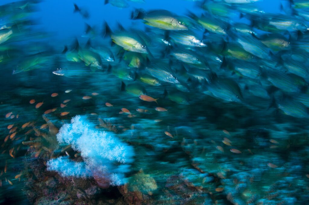
One of the main coastal habitats used by these species outside their breeding season is intertidal mudflats, so the occurrence of these sites constrains where shorebirds live and how they migrate. These places provide them with a plethora of marine invertebrates that live on or in the mud, which shorebirds predate upon at low tide, when mudflats get exposed. Nonetheless, mudflats are not a pervasive feature of the world’s coasts. They are patchily distributed as they are formed in regions where a combination of factors must converge, such as high deposition of sediments usually discharged by large river systems, gentle slopes, and embayments where fine particles settle. Hence, the migratory paths of different shorebird species, occurring in different places during their non-breeding season, are funnelled through comparatively small regions where mudflats are available, constituting critical stopover sites for birds on migration. That is the case of Delaware and Chesapeake Bays in North America, the Wadden Sea in Europe, and the Yellow Sea in East Asia. The latter is the focus of this story.
The Yellow Sea in the spotlight
The Yellow Sea is a bottleneck for the migration of many species of shorebirds in the East Asian-Australasian Flyway. This sea, located in East Asia between China and the Korean peninsula, presents vast mudflats fed by large waterways discharging sediments, such as the Yangtze, Geum, Han, and Yellow Rivers. In the case of the Asia-Pacific, the East Asian-Australasian Flyway includes 22 countries through which over 50 shorebird species migrate. Their breeding grounds include mostly Siberia and Alaska, and their non-breeding grounds Southeast Asia, Australia, and New Zealand. In between their breeding and non-breeding grounds, are two very important stopover regions where birds rest and refuel during their migrations — the Yellow Sea and Japan. A flyway could be generally understood as a region that encompasses the whole migratory range of multiple bird species for which a common approach to their conservation is in place.
But the same factors which make shorebirds flock en masse to the Yellow Sea has also created an opportunity for land expansion. Gentle slopes along the coastlines of this region have facilitated the creation of land by filling or enclosing, intertidal mudflats. This process is known as coastal reclamation and has been practised for decades by different countries around the world, such as the Netherlands. However, this has been practised more recently at a large scale in the Yellow Sea, specifically in South Korea and China. A recent assessment of this sea’s intertidal mudflats has revealed a 65% decrease since the 1950s when they were estimated to cover 1.1 million hectares of the coastline. Traditionally, these newly created lands were primarily used for agriculture, but more recently there has been a shift towards their use as precincts for industrial complexes, housing, and transportation infrastructures, such as ports and airports. Thus, many of the places where shorebirds used to stop in large numbers during their migrations are no longer available to them.
While much attention has been devoted to the loss of other ecosystems, such as rainforests, the consequences of reclaiming intertidal mudflats are no different. In all cases, the loss and degradation of ecosystems result in declines in biodiversity and important functions. Intertidal mudflats provide habitat to a wide diversity of species. These habitats additionally protect coastal areas from storm surges and provide fishery resources, such as shellfish, to local people. As shorebirds get funnelled through the Yellow Sea during their migration, coastal reclamation in this region has a disproportionate effect on their flyway populations. Studies conducted at different sites within the East Asian-Australasian Flyway have revealed abundance declines of migratory shorebirds, many of which rely on the Yellow Sea. These trends are likely to be reflecting flyway-wide population declines. Consequently, five of the species occurring in this flyway have been listed as threatened by the International Union for Conservation of Nature.
The Saemangeum Case
The drivers of coastal reclamation in the Yellow Sea have been complex and involve the interaction of multiple factors. In recent times, the case has been fuelled in China by GDP growth targets set for local governments by the central government. By contrast, the reclamation of intertidal mudflats has been intertwined with political discourses of economic development in South Korea. Additionally, rice has been one of the staples in this country, and with 70% of its land being mountainous, there has traditionally been pressure to expand agricultural land. Since the 1960s, this country had a strong policy to increase national rice production as its yield was then insufficient to meet internal demand. As a result of this policy, the country reached sufficiency in the mid-1970s, which was also a consequence of decreased demand as South Koreans’ diets became more diversified.
The process of coastal reclamation in the Yellow Sea has comprised multiple projects; nevertheless there is little doubt that Saemangeum, in South Korea, has been by far the most prominent. This project, led by the Ministry of Agriculture and Forestry, is considered to have triggered the rise of environmentalism in this country. Saemangeum is the estuary of the Mangyeung and Dongjin Rivers close to Gunsan City, 180 km south of Seoul, on the Yellow Sea coast. This area was selected for reclamation as a commitment made by President Roh Tae-woo during his campaign in 1987, but the site had initially been identified since 1971 as part of a national plan for the modernisation of the rural economy. The project officially commenced in 1991 and saw the final completion of a 33 km seawall in 2006, enclosing an area of 40,100 ha, of which 28,300 ha would be new land.

The consequences of Saemangeum for migratory shorebirds were considerable. With the seawall completed, the tidal flow was stopped, so mudflats were now either permanently underwater or permanently exposed. This outcome meant shorebirds could no longer access food resources. The submerged mudflats were now out of reach, while the exposed mudflats became devoid of marine invertebrates important for shorebirds, such as bivalves, because they perish in the absence of regular flooding. This estuary was one of the most important sites for migratory shorebirds in South Korea, as it used to provide a stopover habitat for up to half a million shorebirds during their northern and southern migrations each year.
The reclamation of Saemangeum had a turbulent history prompted by a previous environmental disaster. Despite little opposition on the horizon when initially proposed, there was a precedent that sparked environmental activism in an attempt to avert the debacle. Just a few years after this project had commenced, a similar project, known as Shiwha Lake, was being completed with unintended consequences. An estuary where six rivers flow, 35 km west of Seoul, had been enclosed by the construction of a dyke, a project conducted between 1987 and 1994. The purpose of this scheme was to create a freshwater lake for agricultural irrigation, as well as to accrue land for urban and industrial development. As a consequence of land-based pollution, primarily from factories established in the newly created land, the water from the lake became unsuitable for irrigation. Furthermore, any plan to remove the dyke was hampered by the presence of new constructions in low lying areas that would inevitably get flooded. Hence, the Shiwha Lake project rang alarm bells amongst NGOs and civil society about the potential consequences of allowing Saemangeum to proceed.
A disparity of values and powers set the scene for a battle amongst multiple stakeholders over the construction of Saemangeum. The initial purpose for the new land was principally rice production, but an expectation of potential industrial development similar to Shiwha Lake created support amongst some of the local people. This estuary is located in North Jeolla Province, a region quite far from Seoul and one of the least industrialised regions of South Korea. Hence the project gained the support of the Ministry of Agriculture and Forestry, the government of Gunsan City, and some local people as well. On the flip side, NGOs, scientists, religious groups, and some local residents raised their voices against it, particularly as the consequences of Shiwha Lake became evident. Additionally, opposition came from the international sphere. For instance, the Ramsar Convention on wetlands leveraged views in favour of protecting this site, as did international NGOs, such as Greenpeace and Wetlands International. Concerns ranged from biodiversity conservation, including shorebirds, to potential pollution and loss of livelihoods for local fishermen.

The dispute was taken to court, but the final outcome was almost inevitable given the political nature of the proposal. The construction of Saemangeum was stalled for one year in 1999 amid the intensification of disputes between stakeholders but eventually resume after a feasibility study and an Environmental Impact Assessment. As a response to this outcome, a lawsuit was initiated by NGOs and some of the local people opposing the project, who sued the then minister of Agriculture and Forestry to relinquish the completion of Saemangeum. Even though the verdict was at first seemingly in favour of conservation, the defendant appealed the case to the high court, whose final, and ostensibly irrevocable, the decision was to allow the project. More recently, the plan for the area has shifted from primarily rice production to chiefly urban, industrial, and infrastructure development. In the meantime, the promise of economic prosperity for the region by destroying this wetland has yet to be fulfilled.
When history twists
Just north of Saemangeum is the Geum estuary, the mouth of one of the most important rivers in South Korea, the Geum River, and a tremendously significant site for migratory shorebirds. This estuary had also been selected by the central government to be reclaimed as part of a model underpinning economic development. In a twist, the central government withdrew its plans to reclaim it in 2007, but this decision would require negotiation with Seocheon, the local government area in question. After all, Saemangeum had promised to deliver economic benefits to the neighbouring city of Gunsan and the Seocheon local government was asking the central government for a similar plan to bring economic benefits to the region.

The central government swapped reclamation for research and education in this instance. Part of the alternative provided to Seocheon City included two government-affiliated research centres, the National Institute of Ecology and the National Marine Biodiversity Institute. The former opened in 2013, and the latter in 2015. These two institutions have research and education mandates. For instance, the National Institute of Ecology includes state of the art research facilities and an exhibition building containing an impressive collection of plants and live animals. Importantly, one of the goals of these institutes is also to draw tourism to the region, hopefully boosting the local economy. So far, the target number of visitors to the National Institute of Ecology has surpassed expectations. The establishment of these two institutes has also created a favourable setting for rolling out additional conservation initiatives. For instance, a Memorandum of Understanding on the conservation of the Geum estuary was recently signed by BirdLife International and the Seocheon local government.
Beyond the local, there is a range of institutional arrangements in the Asia-Pacific with relevance to the conservation of intertidal habitats in the Yellow Sea. Some of these include bilateral migratory bird agreements signed by China and South Korea with counterparts including Japan, Russia, and Australia. There are additional agreements, such as the Ramsar Convention on Wetlands, the Convention on Biological Diversity, and less formal ones, such as the East Asian-Australasian Flyway Partnership and a Memorandum of Understanding on migratory waterbirds signed by WWF and China’s State Forestry Administration.
Final remarks
While they may sound attractive, what do the brand new research institutes in Seocheon really mean for conserving the Geum estuary? Likewise, what can all the above mentioned institutional arrangements achieve to better manage coastal ecosystems in the Yellow Sea at large? Answering these questions is challenging. Commitments made by governments to conserve intertidal mudflats compete with other national interests that often seem to take priority. Reclamation has not been completely stopped either in South Korea or China. Nevertheless, at least the Geum estuary continues to have intertidal mudflats free from reclamation. Amid constant pressure for economic development in important shorebird areas, only time will tell whether actions by governments are sufficient to conserve the Geum estuary and many other sites they have pledged to protect.
Further reading:
Murray NJ, RS Clemens, SR Phinn, HP Possingham, & RA Fuller. 2014. Tracking the rapid loss of tidal wetlands in the Yellow Sea. Frontiers in Ecology and the Environment, 12, 267-272.
Wilson HB, BE Kendall, RA Fuller, DA Milton, & HP Posingham. 2011. Analyzing variability and the rate of decline of migratory shorebirds in Moreton Bay, Australia. Conservation Biology, 25, 758-766.
Gallo-Cajiao E & RA Fuller. 2015. A milestone for migratory waterbird conservation in Asia-Pacific. Oryx, 49, 393-394.
Choi, YR. 2014. Modernization, development and underdevelopment: reclamation of Korean tidal flats, 1950s-2000s. Ocean and Coastal Management, 102, 426-436.
This manuscript is additionally based on ongoing research conducted by the author and the lab he belongs to. For further information go to: www.fullerlab.org
Photograph: Eugene Cheah, Nicholas Murray, Micha V Jackson, Jen Dixon