Robert ‘Bob’ Pressey is Professor at James Cook University, Townsville, Australia. He is one of the world’s leading conservation planners, and was one of the pioneers of the method of systematic conservation planning. He has extensive experience in marine, terrestrial and freshwater environments in many parts of the world and is one of the few researchers in conservation science with a strong history of connection to managers and policy makers. He now leads a large research group in planning and management for coral reef conservation, with study areas in the Coral Triangle, western Pacific and further afield. He has published 132 peer-reviewed journal papers and 25 book chapters, with over 8000 citations of his papers. His numerous national and international awards include election to the Australian Academy of Science in 2010.
DD: How did the idea of systematic conservation planning come about?
BP: The first person to conceptualise systematic conservation planning in its rudimentary form was Jamie Kirkpatrick, in Tasmania. He did the work in about 1980 or so, but he didn’t publish until 1983. So I’d date systematic conservation planning to be 30 years old this year. Jamie was the first but, interestingly, others had the same sort of idea at about the same time. In the years that followed, CSIRO , the Natural History Museum and Tony Rebelo in South Africa independently built these ideas. The basic idea was to break away from the ‘scoring approach’ as it was being used at the time. The scoring approach is quite explicit, which was one of its appeals, but it had limitations that were understood only later. With the scoring approach, people ask what makes a place valuable: richness, rarity, biodiversity, or other criteria? They rate each place—which could be a forest fragment, or a beach, or a farm—according to one or more criteria. They work out some way of defining each criterion and then combining it with the others, adding or multiplying, and then they end up with an overall assessment of conservation value. This was done a lot and published quite widely, especially in the1970s. The problem with the scoring approach is getting areas that are really rich, say in species, sitting on the top of the list, but all the ones that are highly ranked tending to have the same things in them. You’d just get those things again and again, but not the things that are at the bottom of the list, which could be species needing conservation action. Some things that matter for conservation are only going to turn up in places that don’t have much richness—that’s just the way things are.
What Jamie and others did, independently, was to come up with a better idea. They later found out about each other’s work, and at least 3 groups started working together. I’ve written a paper about that, because it is a nice piece of history in conservation planning, and because I like Jamie and admire his work.
So, Jamie was dealing with rare plants in one square kilometre grid cells in eastern Tasmania. He first tried the scoring approach and realised that, to get every species he cared for protected, he would have to go so far down the list that the required area would be unacceptable to the people whose land would be required for reservation. So he came up with what he called the ‘iterative method’. He identified the grid cell that had the greatest richness of species that was not adequately protected, and that became a notional reserve. That way he took out the species that were being adequately protected in existing reserves. Once the notional reserve was demarcated, he took the species that were being protected there out of the list and recalculated richness. He then took the next richest place, called that reserved, took the species out and recalculated. He did this with pencil and paper—this was before personal computers—and ended up with seven or eight areas that protected all of his species. He then adjusted the boundaries to enhance manageability, and they’ve all become reserves, largely through his persistence.
The reason Jamie’s method was systematic rests on two characteristics. First, he had quite specific and quantitative objectives that clearly defined what he meant by adequate protection. Second, he introduced the idea of ‘complementarity’, although that term was coined later. By going through the iterative method you end up with areas that are complementary in terms of the things they contain.
So with that background, my own start in systematic conservation planning was fortuitous. I had been applying scoring approaches to the evaluation of coastal wetlands, and I got a job with the National Park and Wildlife Service as a research scientist in 1986. I got a bit of funding to look at conservation planning in western New South Wales. I discovered this very early work on systematic methods that was just brewing, and I teamed up with CSIRO and we did some analyses using iterative methods. That led to one of our early collaborative papers demonstrating the advantages of systematic over scoring evaluation.

DD: If you had to use a case study to illustrate the concept of systematic conservation planning as it is today, which would it be?
BP: I can give you two that are from Australia, one of which I was directly involved in. The first one was called the Regional Forest Agreement Process in New South Wales. We had been brewing some new ideas, and by then I was completely committed to conservation planning. And by about 1995, we came up with some new ideas for mapping the irreplaceability of areas, or the options for achieving conservation objectives. We knew this was potentially the basis of an interactive, participatory kind of negotiation. So the next step was to build some kind of software system that would allow people to explore options, and debate and negotiate, and put areas into conservation, pull them out, see what happens, and reconfigure. I guess the planets aligned. We had a new State Government that was committed to expanding the forest reserves system. Our director knew about our work, managed to convince people in high places that it was worth funding, and we got a lot of money to take it forward. We built a software system called C-Plan that ended up being used in this negotiation process. It was used over several rounds of negotiations over about 4 years, the first time in 1996. That was the first time anyone had set up an interactive decision-support tool for conservation planning. We had players around the table who didn’t necessarily like everybody else around the table, but the negotiations were designed so that everyone had to play by the rules. And they knew it was for real in the sense that there were going to be new reserves, it was just a matter of where and how extensive. That was bit of a breakthrough for us in lots of ways. It finally got the doubters off our backs—there had been several calls within the agency to shut down this research, but it was defended by some key people with vision. So finally, these methods were proven to be important and useful, and all the research we’d been doing was seen as worthwhile.

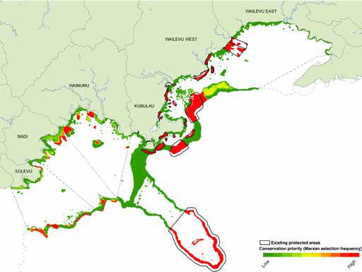
The other one that I’ll mention more briefly is the re-zoning of the Great Barrier Reef Marine Park in 2004. That used a systematic approach, with a different software system called Marxan, but was essentially the same: complementarity, clear objectives, and the like. And that was, demonstrably, quite successful.
What I have come to realise, however, just recently, is that the success stories seem quite idiosyncratic in the global context. The original Forest Agreement Process focused only on public forests. The politicians didn’t want to go anywhere near private land because it was too contentious. And politicians are pragmatists, they wanted a success story, so this was the way to go. The Great Barrier Reef, not to take away from the hard work that went into it, was also in a very simple governance system. There is one marine park, one manager really, the Marine Park Authority. I’m just thinking about the wider replicability of these case studies. One could not do this in the Coral Triangle, for example. There is very complex governance, with finely textured management and ownership, much more resource dependence, and much less occupational mobility. This very common marine situation is analogous to private land. Anything you do for conservation must be slow and accumulate from many small pieces.
That is not to say that good things have not happened in more complex governance situations, but they are not as spectacular. They tend to be small and tend to grow more slowly because when we are dealing with complex governance we’ve got a lot of private landholders or a lot of communities to deal with. It’s necessarily slow, and it’s also necessarily expensive. We’ve got a big challenge for us as conservation planners to deal with those widespread complex situations. And we should be careful because we can’t just say “look at these two case studies from Australia, now we can go out and do this everywhere”, because we can’t. The idea is good, the idea is translatable… but with considerable adaptation.
DD: So, C-Plan, the software you developed, how does it work?
BP: Well, we developed C-Plan in 1995-96. We’d been working with an idea called ‘irreplaceability’, which is a twist on the analytical methods that were being developed earlier. The basic ingredients are still the same. We have a table of areas and features showing the species and vegetation types that each area contains, with areas or abundances when we know them. We have objectives for each of the features. But instead of finding a set of areas that achieves all our objectives, we put a value on every place that is the likelihood of it being needed.
Running an analysis to get a predetermined set of areas gives somewhat artificial answers. It might say these are 42 areas needed to achieve our objectives, perhaps accounting for existing reserves. But are those 42 areas the most important in that region or are they the ones that emerge from the computer analysis, because of the rules you taught it to use? Really, it’s the second. There might be a thousand ways of putting together a set of 42 areas, all slightly different. Some of those first 42 sites chosen by a single analysis will be unique, so you will have to have them. Some of them could be pulled out and replaced with 20 or 50 others. So you’ve got room to manoeuvre. What you can’t see when a computer programme selects a single set of areas is your room to manoeuvre.
Irreplaceability puts these areas in a scale between 1 and zero. 1 means that if that area is not protected, you will fail to achieve one or more of your objectives. In other words it is fully irreplaceable. At the bottom end of the scale, you have areas with lots of spatial options. It was obvious to us from the start that irreplaceability wasn’t static because once you started making decisions using your irreplaceability map, the pattern would change. Imagine for example that a portion of your landscape was identified as not available for conservation, being politically committed to logging or farming.
Immediately after that, other places that are available would become more irreplaceable, because they become more important to achieve your objectives. You’ve then got fewer options spatially. On the other hand, if you are going to choose 12 areas and commit them to conservation, this will achieve quite a few objectives making some of your other areas less irreplaceable. So we knew from the outset that a map of irreplaceability would be dynamic as we made decisions. And C-Plan was a dynamic system that allowed us to work like that. We had bit of a dream when we were making it, in that we visualised people sitting around and negotiating. We built it with the stakeholders over a period of months. We showed them a prototype and they gave us feedback. We thought there was no point in showing just how the options change unless you can tell how much closer you are to your objectives after several rounds of decisions. So we brought up tables, built a lot of interactivity, some requested and some initiated by us. If you take an individual area and ask what is making it irreplaceable, you’re also going to find that out. So there was a lot of graphical support. And a year and a half of hard work later, it was actually happening. We were in the negotiation room making decisions, and had a really useful software system that was then applied to many different regions around the world.
DD: Systematic conservation planning seems to be a very data-intensive procedure requiring extensive field work, etc. which may take a lot of time and may not always be viable. How would you make systematic conservation planning attractive to policy-makers, or people who want quick solutions to conservation problems?
BP: The image of systematic conservation planning being data-hungry and therefore intractable in most places is artificial. There are lots of places even in Australia where there are not enough data to plan properly with species. Instead we have to work with what we have: a map of vegetation types, or an environmental classification. So we’re assuming for the purpose of this planning exercise that representing a sample of each of those environmental units or vegetation types is doing pretty well for biodiversity at large, even though we don’t know a lot about the species. And that is a very common approach around the world. One has to decide the minimum required to do systematic conservation planning. It could be some kind of uniform subdivision of the landscape into units like vegetation types or environments that we hope reflects the distribution of biodiversity composition, or differences in biodiversity. And this is used commonly. Another thing that would be useful to know is transformation, or conversion of native vegetation to crops or towns. We all have freely downloadable satellite imagery that could be used for that. So there are a lot of data out there right now that could be pulled together in a relatively short time to do an exercise in systematic conservation planning. Obviously you always want more data, but even in really well known areas you have to make pragmatic decisions or judgements about how much data you have and how much of them you can use. And there are lots of situations where we don’t have the time or the money to go and get more data.
DD: And to work with C-plan, how much data would I need to feed?
BP: Generally speaking, the more data the better. But you can drive C-Plan with a vegetation map or map of physical environments and nothing else if you have to.

DD: So it has built-in systems that will extrapolate from that given data…
BP: Not really. The thing about conservation planning software is that the system will help you identify priority areas, but there is nothing absolute about priorities. Priorities are a function of the data you put in and the objectives you set. You change your dataset, the priorities will change. Change your objectives and hold the data the same, and your priorities will change. So you can absolutely use C-Plan with nothing more than a vegetation map, but you’d get a different answer than if you had a vegetation map plus data on species. And that’s just the way conservation planning is. But what we hope is that, if all we have is a vegetation map, then we will come up with a more intelligent set of conservation areas than if we had just placed them at random or in a totally ad-hoc way.
DD: So you are saying that systematic conservation planning can be used even in data-scarce situations? Because that would be a pertinent question in the Indian context
BP: Yes that is right. But remember that there are plenty of data-scarce situations in Australia too. I’m sure that systematic conservation planning can be used extensively in India, and it has already been applied in the Western Ghats. Here’s an example of data scarcity in Australia. Across the islands in the Great Barrier Reef, we have a project on prioritising management actions. We’re working with the managers; they are very keen on this and want to be part of the process. You’d think that with all the studies from all the universities over the years that the islands would be very well known. We were looking at data and found huge holes in knowledge, of species in particular, and even the vegetation mapping is quite patchy. So now we have to decide what our minimum dataset is going to be. What is acceptable as a basis for prioritisation? We will go to the managers, show them aerial photos of where vegetation mapping has not been done, and ask them what vegetation types they think are there. That is how we are going to fill the gaps in our data table. Species data across the islands are a complete mess—very patchy both spatially and taxonomically. Someone has worked extensively on lizards on three islands and that is it. So there is a big data table with islands as rows and species as columns, with a huge number of false negatives. We cannot use most of those species in this planning exercise because we cannot fill the gaps. So we will focus on a few key things like nesting turtles, nesting seabirds and federally or state listed threatened species, and a few plants and vegetation types. We’ll try to be explicit about the uncertainties involved. That is a very small of snapshot of biodiversity, but that’s what we have to use.
DD: So coming back to systematic conservation planning generally, what have been the major challenges since it started, and how have they been managed?
BP: Well, I’m going to talk about one. In 30 years, the conservation planning community has done a lot of clever work, had policy uptake and legislative uptake in some areas. But I think it’s fair to say there’s been a lot less implementation than planning. We have done a lot of plans with the best of intentions, and a lot of them have just not led to anything. So there is a big gap between designing conservation areas and actually making them happen. solution to overcoming that barrier is multipronged, and we’ve yet to work out how many prongs. There is not any one factor that one can identify and say if we can nail that, we’ve solved the problem. There’s going to be twenty or more of those factors. A lot of it revolves around governance and understanding people’s needs. Taking the time to actually work with people is very important, which is what we’re seeing here through the work on marine governance.
And one of the sources of that barrier I suppose is that a lot of scientists stop at the planning phase, write a paper and move on. Not many follow through. And that is why organisations like The Nature Conservancy (TNC) are really doing some very important work, because they are there to follow through. They too have done a lot of plans that have stayed on the shelves as well, but their ‘business’ is trying to make a difference in ways that are consistent with all the planning that they are doing. I think that, among all the big NGOs, TNC is doing very well in bridging the gap between planning and application, although TNC is facing some difficulties too. That is something that interests me a lot, because like a lot of people in the science of conservation planning, I would be very disappointed if I finish my career and just had a long CV and nothing to show for it in terms of outcomes on the ground. So that’s the biggest challenge for us.
DD: So that would be the way forward?
BP: Yes. There are a lot of people working on that and making some progress. And my main reason for visiting India is to learn more about how to combine Australian technical expertise in planning (which can be adopted readily with the skill base here in India) with the advances made here in “conservation with a human face”. I like working in places where nature conservation is faced with challenges. Indian scientists are showing us that there are ways to overcome those challenges.
DD: Finally, before we wrap this up, is there something you would like to add.
BP: Well, probably that this is my first time in India, and it’s been a fantastic trip. I’ve met some great people and I’m learning a lot. This trip was about starting collaborations and working with people here, and it looks very promising. I find that prospect very exciting. I look forward to coming back.
DD: We look forward to seeing you here again! Thank you so much for your time.
BP: Thank you!
Photographs: Steve Hall, Rebecca Weeks, WCS Fiji/ Rebecca Week