Marine mammal conservation and the role of research

Marine mammals are a diverse and widely distributed group of animals that includes the biggest animal to ever exist (blue whales can be up to 30 metres long), the world-record breath holder (beaked whales can stay underwater for over 2 hours), and some fearsome predators (e.g., polar bears, killer whales, leopard seals). Marine mammals are found from the tropics to the poles and from estuaries to the deep ocean. The roughly 125 different species of marine mammals come from three Orders of mammals (Cetaceans, Sirenians and Carnivores) and each has different habitat requirements, prey preferences, and distributions. Our understanding of the role these animals play in their ecosystems and how the ocean influences their distribution and behaviour is hindered by the very environment in which they live. For instance, while pinnipeds (seals and sea lions) are amphibious and give birth and nurse their pups on land, the cetaceans (whales and dolphins) only come to the surface to breathe and spend over 95% of the time underwater. This can make studying these animals, their environment and the potential impacts of human activities on them (e.g., whaling, fishing, climate change) difficult. To overcome these challenges, a suite of new tools has been developed to better understand the role of animals in their environment and how this information can be used in the conservation and management of marine mammal populations. Here we will focus on threats to, and tools for studying, whales and dolphins.


THREATS
When most people think of threats to marine mammals, they likely harken back to commercial whaling. From as early as the 1600s up until late in the 21st century, large whales were the targets of whalers for their baleen (sometimes called whalebone even though it is not bone, but made of keratin like our fingernails and hair) that was used in women’s corsets and for umbrellas or riding whips, their blubber that was rendered for lamp oil, industrial lubricants and margarine, and for their meat and bone that was often ground up for fertilizer and dog food but also used for human consumption. Because of the vast scale of commercial whaling, by the mid-1900s, populations of most species of large whales were nearing extinction. At present, protected by a global moratorium on commercial hunting by the International Whaling Commission, many populations of large whales seem to be recovering, although this is often difficult to accurately assess.
For populations that are not increasing, other human activities have been implicated in hindering recovery. For instance, ship strikes are one of the key reasons the North Atlantic right whale remains highly endangered. Interactions between humpback, blue and fin whales and commercial cargo and cruise ships are on the rise in the northeast Pacific and the northern Indian Ocean in part because shipping lanes and productive feeding grounds of these species coincidentally overlap. Perhaps the greatest threat to small whales and dolphins today is the accidental entanglement of these animals in fishing gear; as many as 1000 animals per day are caught in nets and on longline gear where they drown because they are unable to surface to breathe. Large whales can usually break free of nets but may end up towing heavy gear or having lines trapped in their baleen, impeding feeding.

A humpback whale fluke (underside of tail). Each fluke is unique to an individual, much like our fingerprints. Such photos can be used to estimate population size, track individuals over time and space, and provide data on longevity.

Human activities in the ocean, such as commercial shipping and oil and gas exploration, often create a great deal of sound, which can sometimes be harmful to whales and dolphins. Cetaceans rely on their hearing more than any other sense to communicate, navigate and find food, so increases in ambient noise from human sources may interfere with these vital activities or even cause physical harm. Just like a loud party or music concert reduces the distance over which you can effectively communicate with a friend, elevated ambient noise can severely reduce the “communication space” of whales trying to convey information to other whales that are hundreds of meters to tens of kilometres away (sound travels much farther in water than in air). Noise has been shown to increase stress in large whales, and there is evidence that some sonars may even lead to strandings and death in beaked whales.

Finally, climate change may be one of the least understood but most significant threats to marine mammals. Climate change has been underway in the Arctic for the past decade, and changes to the ecosystem related to the disappearance of summer sea ice are readily apparent. The amphibious marine mammals that rely on the ice to rest, such as polar bears and walrus, are spending more time and energy swimming at sea, which impacts body condition, health, and survivorship. “Invasive” sub-Arctic cetaceans, such as humpback, fin and killer whales, are becoming more common in Arctic waters, and will undoubtedly compete with endemic species for prey. With changes in the environment come changes in human activities, and the ice-free Arctic is being increasingly used for industrial activities, like oil and gas production, commercial shipping and eventually fishing. Like in other parts of the world, these human activities will have an impact on marine mammals and will ultimately change what was until only very recently one of the most pristine environments on the planet.

THE RELATIONSHIP BETWEEN SCIENCE AND CONSERVATION
Given such threats, how does one go about “saving the whales”? The anti-whaling movement of the 1970s was part of a broader public awakening to our impact on the environment and was motivated by the very direct and deliberate killing of marine mammals. Harm to cetaceans today is largely unintentional, simply the cost of doing business in the ocean. Very few fishermen wish whales and dolphins to be caught in their gear (after all, they cause costly damage or even total loss), and very few sea captains wish to hit a whale with their ship.

So how can we help, even when it is our way of life (e.g. our consumption of oil, global transportation of goods, fishing practices) that is causing harm? The best solution may be to separate human activities from marine mammals in time and space or to change marine industrial practices. But to do these, we need a fundamental understanding of the distribution, seasonal occurrence, and behaviour of marine mammals both to identify the risks posed by human activities and to propose solutions that will mitigate those risks. And that is where research and science can contribute to conservation.

Most conservation debates focus on knowledge gaps, and our role as scientists is to inform these debates with meaningful research. Often, scientists can help by answering three fundamental questions: (1) Where do animals go, (2) Why do they go there, and (3) What do they do when they are there? These questions are principally ecological because interactions between animals and their environment have a significant influence on distribution and behaviour. With answers to these questions, a variety of efforts can be employed to remove human activities from important marine mammal habitats, such as designating “areas to be avoided” for shipping traffic, moving shipping lanes around the critical habitat, closing fishing grounds during certain times of the year, or establishing marine sanctuaries. If separation in time and space is not possible, then managing activities within critical habitat may be necessary, such as reducing vessel speeds or restricting fishing practices to those deemed whale and dolphin-friendly. To obtain industry acceptance of these conservation measures, they must be supported by convincing scientific results so that all stakeholders can see that a problem really exists and that the proposed solution will truly help.

An oceanographic mooring with a hydrophone coming aboard a ship after being underwater for a year. Acoustic recordings from this instrument can be used to determine what species are in the area and when, even in poor weather and darkness.


A good example of how science can help conservation is the story of how the shipping lanes approaching St John, New Brunswick, Canada were moved to help North Atlantic right whales. The Bay of Fundy is visited annually by right whales during the late summer, and their presence has been documented by scientists there for over 25 years. Research was able to demonstrate that right whales fed deep in the water column on copepods (tiny crustaceans) and that the local circulation keeps the copepods, and hence the whales, in a discrete area of the Bay. The shipping lanes approaching St John, unfortunately, travelled directly through this high-use area, but through the hard work of dedicated researchers, conservationists, the International Maritime Organisation, and Irving Oil (the major shipper using the lanes), an agreement was reached in 2003 to shift the lanes to the east. This resulted in a 9-20 kilo-metres longer trip for the ships, but the risk of a whale being struck by a ship was reduced by 90%. Although it is difficult to assess the efficacy of the change, the right whale population size was 300-350 animals in 2003 and is about 500 today, and there have been no ship strikes in the Bay of Fundy since the adoption of the new lanes. The scientific research demonstrating how and why the whales used this discrete region facilitated recognition of the problem and the development of a viable solution that all stakeholders could endorse.

TOOLS FOR RESEARCH AND CONSERVATION
Marine mammals are challenging to study because their habitat is difficult and expensive for us to access. However, there are several tools that researchers can employ to learn about these elusive creatures. One of the best ways to obtain information about distribution and abundance is via visual shipboard line-transect surveys in which observers note the locations, species and numbers of all animals seen along the ship’s track line. By incorporating correction factors to estimate how many animals were missed (due to weather conditions or each species’ surfacing behaviours), estimates of abundance of multiple species can be obtained for that region and season. When shipboard surveys also include the collection of environmental (sea surface temperature, water salinity, primary productivity) and prey data, an understanding of what cues drive the occurrence of species can be used to establish why animals are present and how they share or divide ecological niches.

Researchers on a small boat going out to put a short-term tag on a whale. These tags provide information on dive behaviour, swim speed and orientation of the whale. They can also be used to collect information about the environment.


While shipboard sighting data provide insight into broad scale, multi-species habitat requirements, data collected from individual animals can be equally valuable. Many cetacean species are individually identifiable due to pigment patterns under their flukes (tail) and along their sides, or from body scars or nicks in their dorsal fins. Long-term photo-identification projects in which individuals are documented in numerous instances over different spatial and temporal scales can be used to examine longevity, migratory patterns, site fidelity and determine population-level estimates of abundance. A small skin and blubber sample (biopsy) from an animal can help determine not just the identity and sex of the animal, but also information on diet (from fatty acid analysis), hormone levels (used to assess stress levels or reproductive status), and environmental pollutants can also be obtained. All of these data provide a better understanding of the environment in which animals live and can point to possible sources of stress.

Many of the visual techniques mentioned above provide information from animals at the surface, and at single points in space and time, but more detailed information on the habitat requirements of individual animals can also be obtained by using data-logging tags. These tags can be short term (lasting hours to days) or longer term (months to over a year). Short-term tags are often attached to an animal with suction cups and the data they collect are recovered after the tag has detached. Recent technological advances allow collection of depths, swim speeds and orientation of diving whales. Simultaneous collection of prey, temperature and salinity within the vicinity of the whales allow for a three-dimensional underwater portrait of the animal in its environment and can provide information on what depths and prey are being targeted. Short term tagging has been used to study the effect of man-made noise such as sonars on animals by using playbacks of sounds to tagged animals to study how these sounds change diving, swimming or vocalising behaviour.

A researcher looks through “big eye” binoculars on a largescale survey for marine mammals. Data collected from such surveys can be used to estimate population sizes and determine habitat partitioning for different species.


Longer-term tags, called satellite tags, enable scientists to track animals over long time periods via satellite telemetry. This movement data can be used to determine swim speeds and migratory movements as well as habitat and home range information. When combined with environmental data from satellites, associations of cetaceans with fronts, eddies or seamounts can show how these ocean features influence marine mammal movement and distribution.
Tagging data often provides information from only one to a few animals in a population.

For population-level monitoring, listening to animals can provide a robust overview of what species are present and when. All marine mammals make sounds and these sounds are species-specific. That is, they are relatively straightforward to tell apart. The use of short and long term hydrophones (underwater microphones) has become a robust means of studying marine mammals. The advantage of recording animal sounds is that sound can travel great distances underwater thereby increasing the area over which animals can be monitored. Sounds can be recorded 24 hours a day, all year long in poor weather and light conditions, and areas too remote to feasibly monitor with other means can be studied over long time scales. Because hydrophones record all the sounds in the environment, ambient noise levels in the ocean can be monitored along with multiple species of marine mammals. Passive acoustic monitoring has been used to identify different acoustic populations of blue whales in the Indian Ocean and measure the influence of shipping on the communication space of right whales in the North Atlantic.

The tools and methods used to study marine mammals should be dictated by the research and conservation questions that need to be answered and the resources available to do so (from funding to ship time). Where very little is known about the community composition within a country’s exclusive economic zone, a series of shipboard based visual surveys might be the best way to obtain baseline information on the geographic and seasonal abundance of multiple species. A researcher looks through “big eye” binoculars on a largescale survey for marine mammals. Data collected from such surveys can be used to estimate population sizes and determine habitat partitioning for different species. The tools and methods used to study marine mammals should be dictated by the research and conservation questions that need to be answered and the resources available to do so (from funding to ship time). Where very little is known about the community composition within a country’s exclusive economic zone, a series of shipboard based visual surveys might be the best way to obtain baseline information on the geographic and seasonal abundance of multiple species. These data can be used to identify critical habitat and conservation needs. Repeated surveys over time can indicate changes in populations that may be linked to environmental or management changes. Passive acoustic monitoring can also be a helpful tool for understanding the seasonal occurrence of animals and identifying the presence of previously undocumented species, assuming their calls have been documented. From here, finer-scale studies can be undertaken to answer conservation questions about region- or species-specific issues. Whatever the scale, coordination amongst researchers, resource and/or expertise sharing and technology transfer are critical to a successful marine mammal conservation program.


A WAY FORWARD IN THE INDIAN OCEAN

An Antarctic petrel investigating a biopsy dart with a skin and blubber sample in it. These samples can be used to determine the population identity, sex, and diet of the animal from which the sample is taken. The samples taken are about the size of a pencil eraser.

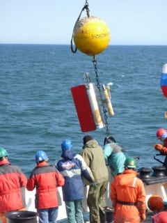
The Indian Ocean contains arguably the highest diversity of cetaceans in the world’s oceans, yet research in this region has been extremely limited. Oceanic waters are difficult to access for marine mammal scientists from neighbouring countries because large vessels from which research can be conducted are prohibitively expensive to charter. There are opportunities, however, to partner with the oceanographic community, the members of which routinely conduct marine research on large state-run vessels. Increased training for regional scientists and students is critical to building capacity in marine mammal research in order to take advantage of these excellent survey platforms. An Antarctic petrel investigating a biopsy dart with a skin and blubber sample in it. These samples can be used to determine the population identity, sex, and diet of the animal from which the sample is taken. The samples taken are about the size of a pencil eraser. We recently participated in a pilot cruise aboard the US research vessel Roger Revelle to the oceanic waters of the Bay of Bengal during November and December 2013 to train Indian and Sri Lankan scientists on marine mammal survey methodology. Training included the use of both deck-mounted “big-eye” 25X150 binoculars and Wincruz marine mammal survey software, as well as rigorous species identification during daytime survey activities and evening at-sea classroom instruction. In total, 52 sightings of 12 different species were recorded, which allowed trainees ample opportunity to practice their new species identification skills. We have plans to continue these training surveys aboard Indian oceanographic vessels that conduct research in the Bay of Bengal and hope that by doing so, marine mammal expertise and research opportunities will expand in the region.

Photographs: Kathleen M Stafford, Mark F Baumgartner

This article is from issue

8.2

2014 Jun

Of Chilika, dolphins and people

It was a rainy day 12 years ago when we drove alongside fresh green paddy fields, with the smell of moist red earth and the occasional showers of Holi colours, to visit a place that would occupy my mind for the best part of the next decade. It was during that visit in 2002 to Chilika, a brackish water lagoon tucked away in southern Odisha, that I saw my first Irrawaddy dolphin—Scoopfin —with a calf. I kept my eyes on and heart with her all through the next eight years. But I wonder how she is today, how many calves has she had, which other females she is foraging with and if they are still getting enough of mullet, dogfish and popcorn fish. I wonder when and how our paths will cross again. My first visit was just by chance after all. I wonder how Chilika has changed since I left because the ecological system is dynamic and disturbed, but some interactions remain stable, maintaining the essence of Chilika.

In 1999, while working on a project on olive ridley turtles, I stayed for months on an other-worldly island I fondly call mine—a strip of land in the middle of the Bay of Bengal, several hours from a payphone, peaceful with its emptiness, its ochre sandy texture against vast grey skies and sultry green seas. The dainty oystercatchers, comic crab dances, and hundreds of olive ridleys right next to the neighbouring island with its missile testing range created a surreal atmosphere on my island home whose only source of light was the stars, the moon and the reflecting sea. It was during those days while observing the belly rubs and body rolls of Indo-Pacific humpback dolphins encircling our turtle tagging boat that I first considered studying dolphin behaviour. All the more when I realised that they were amongst many ignored groups of marine species—not studied because of logistical issues, because we see them but rarely because the data from species that are cryptic hardly makes good science and so on. So, when I finally saw the Irrawaddy dolphins in Chilika, I felt a rush of questions, about the nature of tribes, about the cost-benefits of individuals versus groups, about the formation and breakdown of communities and societies. Here was a population of dolphins, which according to fishers spent all its time inside the lagoon. A closed population of well-marked individuals is an absolute treasure for those who study behaviour.

A misty morning in Chilika


Irrawaddy dolphins are also special as they have adapted to freshwater systems, brackish water lagoons, estuaries and to coastal areas. In India, they are found in Chilika, in Gahirmatha and in the Sunderbans of West Bengal, and the coastal waters from Gahirmatha to West Bengal. The species is listed as Vulnerable by the IUCN and is found in small pockets with a discontinuous distribution from Odisha, India to the Philippines. Five of the six partially isolated subpopulations of this species are listed as Critically Endangered by the IUCN. The population in Chilika is the only lagoonal population that has not been assessed by the IUCN Cetacean Red List Authority. Sadly, we still do not know enough about the life history, reproductive biology, genetic viability, and survival rates of the population in Chilika to be able to do a thorough local assessment.

Chilika is the antithesis of my island in the Bay of Bengal. With an area of 800-1000 square kilometres depending on the season, it is surrounded by around 142 villages and more than 200,000 people depending on fishing and agriculture. Chilika is home to long-tailed fishing boats with engines that can reverberate through you, religious mass tourism, limitless unmanaged garbage, agricultural, domestic and aquaculture run-off, illegal shrimp aquaculture, and most importantly a high degree of inter-village conflict. I returned to Chilika in 2004 for my doctoral research with a fuzzy head full of questions, some of which were suggested, some imposed and a few which inspired me. The thesis project had finally received funding from James Cook University, Australia, Wildlife Conservation Society, New York and from Ocean Park Conservation Foundation Hong Kong.

Scoop fin photographed with a young one by her side in the typical mother-calf position


After the first three months though, the journey changed even more. I realised that knowing the people of Chilika was just as important as knowing the dolphins, not just because it would provide a holistic picture for conservationists, but because the people and the dolphins were in fact inseparable. In this crowded space of dolphins and people, I had to choose between remaining an outsider and merging in to understand the social and ecological landscape on which the dolphins depended. I chose the latter and immersed myself in the local life. My desire to study Scoopfin and her calves, or M Jagger and his band of rowdy males took a back seat. I instead jumped into unchartered territories and decided to learn the discourse of political ecology—a naïve step at the time.

After finding a family in the village to live with, a stable boat driver, Jagga and local research assistants from the village, Loba and Raja, we slowly started drawing out a plan to understand the various aspects that defined the lives of the people and the dolphins. Over a period of 14 months, we divided our time between interview surveys, shore-based behavioural studies of dolphins in the presence and absence of tourism vessels and dedicated boat transects for population estimation and habitat use by dolphins.

M Jagger, a commonly sighted adult individual, probably male and part of a group of 11-13 dolphins


We photo-identified a total of 80 individual dolphins based on natural marks and cuts on their dorsal fin along with fin shape and any additional marks on the body. We estimated the population size to be about 119 individuals using less than 400 km2 of the water body. We found two core areas in the lagoon, one close to the sea mouth used by around 60% of the population and another in south-central Chilika. The dolphins spent most of their time foraging, milling (an individual, or a group searching for prey in an area with synchronised dives and slow movement but in no particular direction and minimal aerial displays) and socialising, with the predominant behaviour in the core areas being foraging and milling. Depending on prey species, the dolphins exhibited both solitary and group foraging strategies in combination with spitting, sideways flipper slaps and tail slaps. Group foraging (presumably cooperative) was seen mostly for catching schools of mullet and dogfish. Mud-plume feeding, usually solitarily along with spitting sideways was observed mainly in shallower regions of the channels for catching scat fish and small-sized prey, while kerplunking (stunning prey using the tailstock and flippers to shoal and catch the fish) with spitting was often observed in dolphins foraging in a group in deeper sections of the channels. Spitting is seen only in two species of delphinids, Irrawaddy dolphins and Belugas. It could be used to either stun prey as explained above or perhaps even as a result of suction feeding in which the dolphin spits out water after filtering in the prey. Dolphins also used shallow sloping shores and stake nets as barriers against which they drove schools of fish. All these behaviours, and new behaviours which may have developed, deserve an in-depth study from a cognitive perspective.

Spitting behaviour associated with foraging activity, exhibited only by Belugas and Irrawaddy dolphins


Our dolphins differed largely based on their individual movements and the stability of their associations with each other. The occasional entry of bull sharks or Indo-Pacific humpback dolphins into the lagoon (after a new sea mouth opened) was one of the few sources of predation on the dolphins. Prey availability would otherwise be the main driving factor for presence and movement. We found that some dolphins were rovers and most were homebodies. Quite a few of the individuals, some of whom we saw with calves did not explore more than 10 km2, while others had travelled between the outer channel and south-central sector exploring up to 200 km2, thus exploring most of the preferred habitat. We hypothesised that the mother-calf pairs stayed close to food sources (Outer channel and Palur channel) and did not venture far even though the Outer channel also brought the risk of bull sharks and larger dolphins. We also found that 14 individuals showed a higher degree of association with each other rather than with others, hypothesising that the population has a stable social structure and does not show fission-fusion (where there is breakdown and movement between groups), and the degree of aggression displayed between individuals was low compared to Bottlenose dolphins and Indo-Pacific humpback dolphins. We do not know if this is a species-level difference or a result of adequate space and food. The only time we perceived aggression, intense socialising with chasing and tail slaps was during mating chases, which are most common during February to April each year. The mating chases are intriguing, with a group of males chasing either one or two females, and can be risky if a young one is with the females. When the chase does not get anywhere, the males behave like a football team, forming a circle with all heads inwards, almost as if they were discussing the next strategy.

A group of dolphins forming a circle with all heads facing inwards, as if strategising the next move.


Assuming accidental mortalities in fishing gears are controlled and prey availability and habitat quality are sustained, the Irrawaddy dolphins in Chilika seemed to fare better than most other wildlife, especially given that Chilika is not a protected area. But how do we ensure though that encounters with fishing nets are mitigated and that fish diversity and densities are sustained?

We hoped to find solutions from the people, on how best to protect the small population of Irrawaddy dolphins in Chilika, and to be aware of all ecological or social factors that could influence these solutions. Our work took us to villages all along the periphery of this coastal lagoon.

Since we were completely new to the lagoon and its complications, each day came with information that was new, complex and surprising. We found the connection between traditional fishers and Chilika to be one of faith and that ‘Chilika Ma’ would take care of them. But shrinkage and siltation of the lagoon and reduction in fish catch had become a source of great concern. The intervention by the government to dredge a new mouth to the sea had helped villages in southern and central Chilika, but had created issues in the villages close to the sea. The three fishing associations of Chilika, once a united body, had also undergone some major changes under this pressure. Once a self-managed fishery, where the village panchayats settled fishing areas and fishing seasons, it had now become one of the most conflict-torn fisheries in the region. This was largely assumed to be due to the shift in ownership of Chilika from its people to the administration, and the advent of unsustainable shrimp aquaculture amongst agriculturists or nontraditional fishers via the World Bank and later by the locals themselves. It is not possible to remove a source of income, however destructive, once it has yielded great profits. So while the ecosystem of Chilika was undergoing drastic environmental changes, over-fishing and drop in fish catch, a greater turmoil was playing out in the social landscape. I cannot pretend that none of this affected me. Trying to maintain an academic stance was not always easy and I wondered if it was even necessary if one wanted to grow personally and professionally. It took a while, but remaining aware of the people and the politics, we started looking at how both people of Chilika perceived dolphins amidst all the chaos.

Dolphin-watching boats and fishing boats in the Outer channel of Chilika


Traditional fishers believed that as long as there were dolphins in Chilika, their well-being and their fisheries would sustain. Our analysis showed that positive perceptions towards dolphins were strongest in people who were most exposed to dolphins during their daily life, that is people living and fishing in the vicinity of dolphin hotspots, those involved in dolphin-watching tourism or those who owned engine boats. We expected age to play a major role in influencing perception, but our sample size was not strong enough to prove or disprove the point. Very interestingly, dolphinwatching tourism grew during the times when fish catch from the lagoon was the lowest. The dolphins that once used to hang around fishers while they were fixing their stake nets soon became an alternate source of livelihood for fishers, buffers to absorb change when externalities had threatened fishing livelihoods, making at least a few of the communities resilient during this time of transformation. At least a few elderly fishers liked this new identity and respect they had derived from being part of the tourism industry.
Earlier, fishers saw dolphins as a blessing from God, as a symbol of ecosystem health, a sign of good fish catch. So if fishers saw dolphins in an area, they would lay out their nets there though gill nets, specially trammel nets, shark nets and hooks-and-lines are the primary cause of mortality in dolphins. And now, dolphins had become a direct source of income, however inequitable, across a range of stakeholders.

A warm sun setting on a winter evening


Studying the growth of this community-driven dolphin-watching industry in the outer channel from a few boats in the 1980s to about 350 odd boats in 2011, was at first exciting, but later bewildering. It was a self-initiated and self-managed business in the 1980s and gained support from government agencies in the 1990s. However, the system still had no way to control or limit the number of boats allowed to approach a group of dolphins, no appropriate guidelines on how to approach and show dolphins, and of course, no cap on the number of villages that could carry out this occupation. But the area they all operated in was just 35 square kilometres. The same people who fished with dolphins, who saw them as a blessing, and asked Chilika Ma (Mother Chilika) for forgiveness when a dolphin got entangled in their nets, apparently did not see what we saw as the effect of uncontrolled tourism.

During our shore-based surveys of dolphins around mechanised vessels, we had not witnessed any boat strikes on dolphins but had observed dolphins changing their behaviour and changing the direction of travel if a tourist boat came within 40-60 metres. Managing boat traffic would be of importance in keeping the dolphins healthy. So we asked all the boat drivers at the association to individually fill up questionnaires. The answers were baffling. All the boat drivers mentioned that dolphin watching stressed and disturbed the dolphins, and this affected the quality of the experience for the tourist. They were also aware of the fishing gears that were most lethal to dolphins and the gears that could lead to loss of fish diversity and abundance in Chilika. They listed solutions to all these problems, including silent engines and propeller guards. But the only aspect they could not respond to was regarding the management of the number of boats in operation at one time. While we held discussions, drew out different route plans to divert boats, and the government body held workshops for dolphin-watching guidelines, another event occurred. Two new dolphin-watching associations cropped up in adjacent villages. When I returned the following season, the original association had shut down and only one of the new ones was active. This pattern continued with the formation and breakdown of dolphin watching associations in the Outer channel of Chilika. Political conflicts over fishing rights, inter-village rivalries, personal agendas, local workings between the revenue department and the various associations were somehow limiting the growth of the industry. I felt some guilt, but mostly relief over these events, and realised that organisational theory and political ecology had much to offer to our understanding of these situations.

I am not so sure how long this resilience displayed by the people and the dolphins will last. But I have learnt not to worry from Bhalu, a 12-year-old boy then, who had held my hand and walked me home on a bad day. Another 13-year-old boy, a football enthusiast who used to take care of his grandparents, used to row me from one island to another in his dug-out canoe. On the way, he used to call out to the dolphins. And every time he did, the M Jagger group would come and circle our little boat. This for me is what Chilika is all about. It is a far cry from serenity, but there are quaint moments, quiet pink sunsets, and fog-covered glassy waters at sunrise. There are dolphins that spit in your face and wiry fishers who smile back at the camera. Amongst all the chaos of those years in Chilika, I actually did find my island of forty-four sunsets. As Exupéry might say, it is hidden, and it is small, and the dolphins that sleep by it, they keep me humble.

Photographs: Dipani Sutaria
 

This article is from issue

8.2

2014 Jun

Editor's Note 8.1

Cities provide the daily living environment for a growing part of the world’s population. Asia and Africa are experiencing unprecedented rates of people moving in to cities, and, along with Latin America, also of urban land expansion. While these rapid and extensive changes lead to considerable challenges for biodiversity, they also create new opportunities
to protect nature in cities and beyond, and enhance the values that nature in cities generates for people.
Cities can and need to support ecosystems and biodiversity, and by that also human well-being. Building on the findings in the Cities and Biodiversity Outlook (CBO) project (www.cbobook.org), jointly led by the UN Secretariat of the Convention on Biological Diversity and Stockholm Resilience Centre, this Special Issue has a particular focus on India, one of the most rapidly urbanising nations in the world, and cities in other countries in the southern hemisphere. It presents some examples of the meaning of nature in cities, and challenges and opportunities associated with urban nature conservation. The CBO-project and the case studies presented here clearly illustrate that the time is ripe to re-envision cities as something else than asphalt and concrete. It is time to acknowledge that rich nature already exists in cities, is part of our culture as well as our
environment, appreciated and actively nurtured by urban inhabitants. It is time to see how the existing green and blue in cities function as ecological corridors and veins, connecting the urban to the surrounding landscapes, supporting the vital functions of cities.
It is time to take the next step and truly explore: What is the scope for nature in cities?
Issue Editors (Guest Editors): Maria Schewenius & Maria Tengö

Coexisting with biodiversity in the city


A blank map of the world fills the screen as 200 students look up at it in a darkened classroom in California. The blankness represent an early time in human history when there weren’t so many of us around. It is an animated map designed to illustrate the growth of the human population across the globe. As the animation moves forward in time, a few dots appear in some parts of the world, and start filling up the blank spaces. Each dot represents a significant center of human habitation, a town or city holding a large number of people. The dark dots start appearing at a faster rate as we get into recorded history, with the pace slackening only in the Americas in the decades immediately after the Old World “discovered” the “New” one. Over the last couple of centuries, the pace really picks up, even in the New World, at our post-industrial exponential rate illustrating how Paul Ehrlich’s (and Thomas Malthus’ before him) population bomb started really going off all over the Earth during the 20th century.


Alongside this map is a graph showing the rate at which species have been going extinct on Earth over the same time period as the map’s animation. At least, our best estimate of how many species have gone extinct. There is a familiar yet disquieting cadence to this dance as the line on the graph sweeps and bounces upwards to keep pace with the rhythm of the dark dots pattering across the map. The lesson couldn’t be made more obvious: as people have increased in number, so have we been pushing ever more and more species off the cliff of extinction. It is the biggest cautionary tale of this Anthropocene, one that every young student must surely absorb deeply if we are to hope that the human juggernaut can be turned around and many non-human lives saved.


Yet, as the young mixture of blank and anxious faces stares at the screen, and up at the professor hammering in the point about how the human population explosion is a leading cause of species extinctions, I can’t help but notice something different. The students have naturally focused their attention mostly on the Americas and on Africa, large land masses with which they are familiar as home, for themselves or for wild animals. These are also places where the recent population growth and extinctions are most prominent, making them more animated on screen.


Over on the Indian subcontinent, though, the dots dance to a different rhythm. This corner of Asia seems to get filled by people quite early in our history, and remains relatively more filled than most other places throughout subsequent millennia. Yet, it is not a region that has seen spectacular extinctions quite like those elsewhere. Yes, we’ve lost the Cheetah, and many other species hover at the brink, but compared to much less populated North America, the Indian subcontinent has managed to retain quite a number of even large fierce species. How has it been possible for a land so full of people as to inspire Ehrlich to write “The Population Bomb” four decades ago, to also hang on to so many wild animals crowded into this tiny corner of the world?


A recent global collaboration (in which I play a part) compiles a database of biodiversity (starting with plants and birds) in the world’s cities. As the database starts filling up with lists of plant and bird species now known to be regularly occurring in 147 (and counting) cities, a number of interesting patterns emerge, fueling further research on urban biodiversity on a global scale. As I have noted in this column before, studying biodiversity in cities and understanding how species find ways to survive and sometimes thrive in the interstices of human habitats is key to how we navigate our way out of the current Anthropocene extinction crisis.


One in five of the world’s bird species (and one in twenty of the plants) now occur in urban areas. More interestingly, over 95% of the bird species found in cities are native to the region. In other words, bird diversity in any city continues to reflect its region’s unique natural history heritage, even as cities seem more alike in this globalising world culture of shopping malls and airports, high-rise apartments and office buildings. Cities may be simpler (compared to a rainforest) or more complex (compared to a grassland) than the natural ecosystems they displace. Yet, the niches in these novel ecosystems are filled mostly by species who evolved in those displaced native habitats. Not really by design or intention, the cities we have built for ourselves somehow serve as arks for more native biodiversity than we imagine. We need to imagine better, and to improve how we design cities so even more species may find ways to cohabit with us on this urban planet.


Yet again the picture from cities in India fuels my unreasonable and skeptical optimism. For here in this land of over a billion people, a land which has always been more heavily peopled than almost anywhere else on earth, even the largest megacities contain over 300 bird species. And hardly any of them are exotic invaders who managed to gain a foothold and usurp habitat from native species. This is in part because the world’s most widespread city-slicker species (the house sparrow, the rock pigeon) figured out how to live with humans early in these parts, and along with the mynahs and parakeets, managed to invade other urban areas while retaining their hold on their native cities in India. The same may hold for primates and some other mammals. But maybe not for plants where people brought in some pretty exotic species which ended up escaping from their gardens to become the most notorious ineradicable outlaws choking the jungles and grasslands across the subcontinent.


Is it India’s mainstream culture of revering nature and finding gods in various animals which allowed so many of them to live among humans? Is it more simply that the early onset of urbanisation in the the Indus valley, in Harappa and Mohenjo-daro, has allowed more time for the native birds (and other wildlife) to adapt to city life? Or is it that the collapse of those once rich cities into deserts burned some ecological lessons into unconscious cultural memory, allowing subsequent development to hang on to bits of wildlife and nature amid human enterprise?


Wherever the answer may lie, we better find it soon. Because it has the potential to help not only India, but cities everywhere in conserving more of the world’s wild species even as more humans turn to city life. Even now, even in anarchically sprawling megacities like Mumbai, something remarkable happens: mangroves come back in Thane creek, paradoxically protected by the newly urbanised populace of Navi Mumbai. And every winter a sprinkling of pink brightens the grey of the tide flats and the dark green of the mangrove canopy, when lesser flamingos by their tens of thousands show up to add color to urban life. We don’t quite know what brings the flamingos into the city, nor why mangroves grow back along the shores of Navi Mumbai’s new suburbs even as developers continue to cut them down elsewhere in the metropolis.


Perhaps it is part of that different rhythm to the dance of the urban human dots on that map in that California classroom. Somehow, both Indian culture and biodiversity have remained surprisingly resilient even as humanity transformed the entire planet. The real challenge ahead will be to not throw that cultural and natural historic legacy away, but to show the rest of the world how human development can be reconciled with conserving other species.

This article is from issue

8.1

2014 Mar

Challenges and opportunities for nature conservation in Rio de Janeiro: Peninsula and Inhaúma

Rio de Janeiro has a history of biodiversity restoration and conservation dating from the 1800s. The area was originally covered by the Atlantic Forest complex (or Atlantic Forest senso lato), a mosaic of ecosystems including rainforest, mangroves, Restinga (sandbanks), wetlands and beaches. The Atlantic Forest is one of the biodiversity hotspots of the planet but, only about 11-16% of its original area remains. Urbanisation and agriculture have drastically transformed the landscape, not only by deforestation but also by elimination of entire hills, intended to allow urban expansion along the shore and in flood-prone lowlands. Economic agricultural cycles, mainly coffee cultivation, were responsible for most of the hills’ biodiversity degradation until the 1800s. During this period the city went through a severe drought, which led to the decision to reforest the Tijuca massif in order to restore specific ecosystem services, such as freshwater supply, local climate regulation, botanical explorations, and recreation for the growing population. Today, more than 150 years later, the forest still provides numerous services and is protected as part of the Tijuca National Park. The remnants of the native ecosystems are located in private and public areas, mainly in Federal, State and Municipal Conservation Units. Forests, mangroves, and other natural ecosystems are estimated to cover about 18% of Rio’s urban area.

Urban nature is so important that the city received the UNESCO’s World Heritage Site award in 2012, as “Rio de Janeiro: Carioca Landscapes between the Mountain and the Sea”. Beaches and parks are assets that attract residents and tourists. The city is physically divided by the massifs of Tijuca and Pedra Branca. The slopes are mostly covered by restored Atlantic rainforest and exotic tree species.

Like many of the Global South cities, Rio has high social-ecological contrasts and inequities: built-up areas adjoin slums (favelas), mostly located in vulnerable deforested slopes and flood-prone lowlands, spread in the urban tissue; expensive residential and commercial developments are located closer to coastal zones; the inland region is characterised by densely living, lower-income populations, poor infrastructure (sanitation and public transportation), and land mostly deprived of vegetation and public spaces.

Rio de Janeiro faces many challenges related to urban expansion, such as floods and landslides, increasing urban heat island effect, severe traffic congestion, and air and water pollution, among other hazards to human health. Nowadays, the expansion is sped up by public and private investment flows to promote several international events that have boosted the city’s image worldwide, mainly the 2016 Olympic Games. These investments support real estate developments over lowlands in the city’s west zone, causing radical landscape transformations that follow the historic occupation patterns of eradication of ecosystems and biodiversity, even with alterations in environmental legislation.
Despite the ongoing negative trend, tools and mechanisms that can help to support biodiversity and ecosystems in Rio do exist, as the following two examples will show.


Península – top-down initiatives of environmental legislation and ownership rights
Environmental legislation was responsible for the implementation of protection and restoration of biodiversity in the late 20th Century. The most successful case is located in the Jacarepaguá lowlands—a lagoon system. In this area, a modernist urban plan designed in 1969 by the architect and urban planner Lucio Costa , envisioned the future city center in a wetland, with sprawled car-based gated communities and shopping malls along the main highways. In the plan, the lowlands were divided in glebes—large lots of land—that attracted powerful real estate investors. In the following decades, after the opening of a new road system, the occupation was fast, and led to a deep transformation of the landscape: from native ecosystems to lawns and “homogenised” ornamental gardens with few exotic species. However, the area has still today about 30% of vegetated land cover.

In order to enable the development of a strategically located 750,000 square metres residential gated community named Península, in 1986 the glebe’s owner hired Fernando Chacel, a famous, ecologically oriented, Brazilian landscape architect, to restore and create a 77,000 square metres ecological park on a three kilometres long lagoon-front land parcel. In this manner, the glebe´s owner could comply with the legislation and add value to his land. He foresaw a business opportunity and envisioned a park that could be a magnet for new residents in his property. He also promoted the restoration of mangroves and associated transition ecosystems in a contiguous park, Mello Barreto, and had to protect 207,061.26 square metres in an adjacent Northern glebe. Today, residents recognise native biodiversity and adapted species as one of the main assets of their community.


Inhaúma – the bottom-up initiative of Verdejar
The northern district of Inhaúma is one of the densest and poorest areas in Rio. It has about 118 inhabitants per hectare, and only 1.6% of its territory is covered by green areas. In the late 1980s, a resident known as “Luiz Poeta” (Poet Luiz), started to plant native tree species in one of the few non-built slopes of the region. Other residents joined him in his effort to restore the rainforest, so they could enjoy a better local climate, protection against landslides and further illegal occupation. The informal actions gave place to an active NGO: Verdejar. The transformation is remarkable: large portions of the slopes are now covered by forests, and residents that got engaged in this process started studying to be better prepared to work for enhancing their community. Their many activities combine nature restoration and conservation with local culture and arts. Local production of fruits and vegetables is another target of the organisation. It is a bottom-up approach: people value the biodiversity and the ecosystem services that the forest, agroforestry and vegetable gardens provide. It is a successful combination of nature restoration and positive social change.


Verdejar is one of the many organisations in Rio that are engaged in social and ecological actions. Together, they have the potential to constitute an efficient network of stakeholders that can influence the political agenda. It is, however, crucial that decision-makers of the city develop a deeper understanding of the role of urban biodiversity and the ecosystem services it provides, in order to promote a systemic socioecologically oriented urban planning and design. In this manner, Rio could achieve its full potential to be a real biophilic city.

Photographs: Cecilia Herzog

This article is from issue

8.1

2014 Mar

Beyond business as usual: Why urban biodiversity indicators matter

How can we change ourselves, move beyond “business as usual”, and revert the trend of biodiversity loss in general and in urban areas in particular? Knowing the status quo and monitoring trends in your neighbourhood is one way to go about it. This is where indicators can play a role.

Since its development in the 1970s, at the Organisation for Economic Co-operation and Development (OECD), various instruments have been developed for environmental issues in the city. It started from simple indicators such as urban green areas but the limits were already clear at their early stages. Indicators were unable to deliver their performance because they were split into different categories, mostly according to the administrative units or scientific disciplines. The economic sections monitored trends of housing and energy use, while the environment sections looked into green areas and water use. Ecologists monitored species abundances while school activities are analysed by pedagogics. For certain cities, economic growth was attained at the expense of environmental deterioration. Trade-offs and synergies of different aspects were not taken into consideration. There was a growing awareness that indicators should not be observed as individual numbers but more holistically, monitoring whether your city is moving towards more sustainability or not.

The City Biodiversity Index (CBI, or Singapore Index) is a set of indicators to self-monitor such trends for the cities. It was developed under the framework of the Convention on Biological Diversity when the local authorities in implementing the goals of the Convention were recognised and adopted in 2008. Singapore, lead the process as urban biodiversity was uniquely important for the nation mostly consisting of urban areas.

Various cities and experts joined the development and application of the index, including former hosts of the Conference of the Parties, Curitiba (Brazil, host city of COP8), Bonn (Germany, host city of COP9), and the City of Nagoya (Japan, host of COP10). The index rests on the pillars of ecology, ecosystem services, and governance.

In the book, ‘Urbanization, Biodiversity and Ecosystem Services – Challenges and Opportunities’, the scientific foundation of the Cities and Biodiversity Outlook project (www.cbobook.org), published in 2013, experiences of applying the CBI in different contexts are reviewed and lessons are shared. Besides the technical or terminological difficulties for measuring or definitions, a number of cities expressed difficulties in monitoring ecosystem services and their indicators. Unlike compiling the number of endemic species, where datasets are mostly available in existing institutions, setting baselines for ecosystem services was causing difficulties. In some cases, there were no available ready-made data sets for e.g., costs of water purifications, or carbon storage.

These “difficulties” can be constructive if they can shake up the “business as usual” mindsets. The purpose of indicators is not development or the application per se. It can easily become a routine if ready-made datasets are applied. The development of process indicators can be instrumental in promoting dialogues amongst administrative units to create datasets. In order to monitor ecosystem services, environmental sections will need to talk to construction sections. Ecologists will need to discuss with economists or other social scientists. By doing so, these indexes will promote reflexive thinking for policymakers and scientists. Experience of Japanese cities showed a diverse range of green coverage and species richness. Osaka and Kawasaki were relatively grey for example. The range of “greenness” of Japanese cities is wide since they are formed by their individual histories and economical cycles. In contrast, governance indicators have indicated more similarity across cities. The strategy for greener cities might thus need to be attuned to individual cities with their respective starting points and, in the context of Japan, take into consideration a rapidly ageing society.
In 2014, the slogan “think globally and act locally” means acting in urban parks or forests, school gardens, remaining lands amongst the skyscrapers, or farmlands adjacent to the urban areas, at least for half of the world’s population. Monitoring trends and changes in urban settings will be critically important for the future. We will not be able to address environmental problems unless the studies and tools used include nature in cities and the resource-producing areas that cities depend on. Indicators in your town matter for these purposes.


Acknowledgement
I would like to thank the CBO team and the Grants-in-Aid for Scientific Research (26360062) by MEXT, and Environment Research and Technology Development Fund (ERTDF) by MoE .


This article is from issue

8.1

2014 Mar

Sacred trees in the urban landscape of Bangalore, India


Sacred ecosystems across India are immensely valued and protected resources. Deeply etched in the cultural and spiritual realm of the society, sacred sites have been found to contribute to biodiversity conservation and generation of ecosystem services. In the urban context, such cultural protection of biodiversity has been less acknowledged and recognised. This is in spite of the fact that urban green spaces are under strong pressure while still representing important values for the physical as well as psychological well-being of urban residents.


In cities like Bangalore in southern India, sacred sites act as pockets of greenery in a highly fragmented urban landscape. Bangalore is a rapidly growing metropolitan area, which was once famed as ‘Garden city,’ characterised by its charming tree-lined avenues and bounty of parks. Although trees and green spaces in Bangalore are protected under the Karnataka Preservation of Trees Act (1976), the city has witnessed indiscriminate felling of trees in recent years, to accommodate large scale infrastructure development projects. Yet, sacred ecosystems/sites in the city, so far, seem to show great resistance to the pressures of urbanisation and have survived such rampant incidents of urban deforestation. While passing through the city one witnesses many instances of sacred trees protruding into well-paved streets. It may seem odd to a passerby to see a tree or group of trees intruding into the streets. However, these are simply examples of avenues that have been widened to accommodate more traffic and in the process, lost most of their tree cover except the sacred ones.

An Ashwath Katte with sacred symbols and idols of gods

Sacred trees in Bangalore provide excellent examples of culturally protected ecosystems. In Bangalore, sacred ecosystems can be comprised of trees within a temple site, a heritage site referred to as Ashwath Katte or even randomly occurring single trees or a group of trees. Temple sites may have sacred tree species as described in holy texts, and ornamental species and fruiting trees that are used in ceremonies. The Ashwath Katte is an area with a slightly raised platform, generally with sacred fig (Ficus religiosa) and neem tree (Azadirachta indica) planted together under which one often finds idols of serpent gods. Other sacred species, specifically the Ficus species, may also be found in a Katte. Single sacred trees or a group of sacred trees may be growing on streets, within parks, commercial areas or residential areas that are worshipped by the locals and generally adorned with holy symbols. Sacred figs, neem, coconut trees (Cocos nucifera), banyan (Ficus benghalensis), Indian blackberry (Syzygium cumini), Banni (Prosopis cineraria) and Bael (Aegle marmelos) are a few common sacred tree species found in Bangalore. There are also examples of culturally protected trees at Christian, Muslim and Buddhist sites of worship, for example, the tree cover on burial sites and mango trees (Mangifera indica).
The old city centre of Bangalore—Pete—tells a fascinating story that portrays the resistance capacity of sacred ecosystems. Established in the 16th century, it is an intrinsic part of the historic and cultural identity of the city with a mud fort and mote around it. Pete remains an important commercial centre since when it was first built, which is interlaid with residential layouts. With the city having grown, enormously over the centuries, in the present day, Pete comes across as an extremely congested area, still home to many city residents. It has undergone many changes over the centuries due to various political turmoils, including social, economic and geographic changes. In a sample survey conducted to map the tree cover in Pete, we found that the remnants of tree cover in the sampled plot were mainly sacred. The scattered sacred trees were predominantly sacred figs (Ficus religiosa), that form tiny islands of greenery in the highly built-up environment.

Slum-dwellers selling vegetables and fruits under the canopy of an Ashwath Katte comprised of Ficus religiosa and Ficus benghalensis.

Sacred figs are tall trees with huge trunk areas and large canopies. While saplings of other species do not survive the pressures of urbanisation with the landscape being highly managed, sacred figs are commonly noticed growing in crevices of buildings, abandoned land, etc. The saplings of sacred figs are successful in establishing themselves in disturbed places and are one of the few spontaneously growing species in the cityscape. They are native to the region with many medicinal properties and are actively used in traditional medicine. By and large, fig trees are known to be biodiversity hotspots that nurture urban wildlife including insects, birds and mammals such as squirrels, bats and monkeys.
In slum settlements of Bangalore, sacred figs came across as hotspots of social activities in addition to being worshipped. Slum-dwellers were often seen to be gathering and conversing under the canopy of sacred figs and even carrying out livelihood activities such as selling flowers, fruits and vegetables. The multifunctional nature of sacred sites in slums was further evident when Ashwath Kattes were used as playgrounds by children. Tree canopies provide the much-needed shade from the harsh solar radiation in Bangalore. In slums, due to severe space constraints, most trees encountered were small or medium-sized. The large-sized trees with huge canopies were predominantly sacred belonging mainly to the Ficus genera, providing an excellent platform for social activities.

The sacred fig is believed to represent fertility and rightly so considering the large number of fruits it produces which are much sought after by urban wildlife. In fact, the Ashwath Katte represents the marriage between the sacred fig and the neem tree. There are various beliefs on the significance of marrying the two trees. One such belief is that the male god resides in the sacred fig and the female in the neem—symbolising fertility, therefore, the marriage between the two. During Hindu wedding ceremonies in certain South Indian communities, the bride worships the two trees and circumambulates the Ashwath Katte with the belief that she becomes as fertile as the sacred fig to bear offspring.

Many trees along K.R. Road in Bangalore were axed to make way for an underpass construction and a wider road.

Similar to the sacred fig, most other sacred tree species are native to the region and used in traditional medicine. The neem, Banni and Bael are medium-sized trees with small or medium-sized canopies. In popular culture, the leaves of the neem tree are often used to adorn doors during festivals. During Ugadi, the New Year’s Day in Karnataka and some other southern Indian states, neem leaves (bitter to taste) are consumed with jaggery (sweet to taste) to welcome the New Year wholeheartedly—accepting both bitter-sweet experiences that it may bring along. The healing properties of neem are widely recognised by people. In Bangalore, many residents are often seen consuming neem leaves early in the morning as part of daily health upkeep. In and around a few parks of Bangalore, juice vendors are frequently spotted in the morning, selling various herbal drinks, including fresh neem juice. The banyan tree, on the other hand, is a huge-trunked tree with a dense canopy and areal roots. It is the national tree of India and often considered a heritage tree. Within the Bangalore urban district is one such 400-year-old individual called the Big Banyan Tree—a heritage tree that also attracts tourists. Children are commonly seen playing with the aerial roots of banyan trees across the city. In general, sacred trees are intertwined with the social, cultural and economic elements of society.
The most impressive features associated with sacred sites in Bangalore are those of care and continuity. Devotees and other residents of the locality were often seen to be nurturing and protecting sacred trees. These trends are not limited to species described in sacred texts but include trees worshipped due to personal beliefs. Further, upon the death of a sacred tree, a sapling belonging to the same species is planted and nurtured in the site.

Google Earth image of the Pete area of Bangalore that shows the canopies of sacred trees, demarcated in yellow.

Such practices may not be striking enough to the outside observer, but, when seen in relation to the rapid loss of trees in Bangalore and the planting patterns of the city authorities, their real significance appears. Although the city authorities engage in greening projects, the choice of species planted are of a different kind. The city authorities have a preference towards ornamental and exotic species with small canopies including the Indian mast tree (Polyalthia longifolia) and the royal palm (Roystonea regia) that fail to perform the important social and ecological roles of native and large canopied trees. Furthermore, the saplings planted by the municipality often lack proper care and may not grow into sturdy trees, in contrast to culturally important species that are actively nurtured by local residents.
Active citizens and environmental groups have often come together to protest against the large scale deforestation of Bangalore. While protests have been successful in some locations, yet, the denudation of the city’s tree cover continues. Urban development seems to be the primary agenda of the city authorities. However, sacred trees, heritage trees and other culturally protected trees have so far portrayed resistance against the pressures of urbanisation. Cultural ecosystems across the world are some of the best-protected areas, securing biodiversity values as well as spiritual and other cultural values for humans. To secure pockets of nature in rapidly developing cities, there is great potential in better recognition of the values and practices by urban residents that protect and nurture trees and other ecosystems. There are lessons to be learned for how to design parks and green spaces that engage people in their protection and management, as well as for maintaining a green infrastructure of trees, parks, and other green spaces, that sustains human wellbeing in the city.

Further reading:
Chandrakanth MG, JK Gilless, V Gowramma and MG Nagaraja. 1990. Temple forests in India’s forest development. Agroforestry Systems 11 (3) (September): 199–211.
Nagendra H and D Gopal. 2010. Street trees in Bangalore: Density, diversity, composition and distribution. Urban Forestry & Urban Greening 9 (2): 129–137.
Sudhira HS and H Nagendra. 2013. Local Assessment of Bangalore: Graying and Greening in Bangalore – Impacts of Urbanization on Ecosystems, Ecosystem Services and Biodiversity. (Eds. Thomas Elmqvist et al.) Urbanization, Biodiversity and Ecosystem Services: Challenges and Opportunities: A Global Assessment. Springer. Available online at www.cbobook.org Wilson D and A
Wilson. 2013. Figs as a global spiritual and material resource for humans. Human Ecology 41 (3) (May 3): 459–464.

This article is from issue

8.1

2014 Mar

Colombian urban-regional environments: Emerging ecosystems, emerging logics


A SOCIO-ECOLOGICAL CONTEXT: EMERGING ECOSYSTEMS
Colombia is an emerging economy, with an increasing shift towards urbanisation: it is estimated that by 2020, more than the 80% of Colombian population will live in urban areas.Even though these statistics define Colombia as an urban country, this definition minimises the complex urbanrural interactions in one of the world’s megadiverse countries which hosts close to 14% of the planet’s biodiversity. Thought our cities occupy about 2.5% of the national territory , they have a profound impact on wide territories beyond their boundaries. These small dots , home to so many people, depend directly on the biodiversity and ecosystem services provided by the metropolitan and regional environments, which are dramatically transformed by urban dynamics.

However, these impacts and interactions are not well known because, as in many other countries, the urban system in Colombia has been traditionally approached, defined and managed from economic, social and political motivations, but not in its ecological dimension. Therefore, it’s relevant to promote an ecological reading of the urban phenomena that acknowledges the different typologies of urban systems that exists in a “megadiverse” country.

In this context, Colombia’s urban and rural management present an impressive challenge: on one hand, its natural and cultural diversity across its 1,141,748 square kilometres of continental land and 988,000 square kilometres of marine territories. On the other hand, its complex settlement history that consolidated in a wide and varied system of cities, along diverse ecosystems and not always functional to them.

A national diagnosis found dramatic rates of biodiversity loss in the country and particularly in the regions where cities have developed, mainly in the Caribbean and Andean region, whose ecosystems have been transformed by 72.4% and 62.1% on average respectively. From 2005 to 2010, the Andean Region presented the highest national deforestation rate at 37% (87,090 hectares/year). Ecosystem fragmentation and expansion of the agricultural frontier, two of the main biodiversity loss causes, are directly connected to human settlement pressures, including, urban expansion.

Despite the drastic ecosystem transformation and degradation, Colombian regions still host rich biodiversity, giving place for new socio-ecological characterisations, determined by the constant dialogue between natural and social dynamics. Cities are probably the most important of these emerging socioecosytems, that still have much to be researched and learned of. Therefore, cities have to be visible and interesting for biologist and ecologist, while biodiversity and ecosystem services have to be appealing for urban planners and architects.

APPLYING BIODIVERSITY AND ECOSYSTEM SERVICES CRITERIA TO URBAN PLANNING, DESIGN AND MANAGEMENT
In 2012, Colombia adopted its National Policy for the Comprehensive Management of Biodiversity and Ecosystem Services. The Policy, a result of a wide consultation process, is innovative in several ways and gives hope for biodiversity in future urban planning. It highlights approaches towards resilience, uncertainty, changing scenarios, and multi-scale analysis, addressing how crucial it is to promote biodiversity management not only within protected areas but especially within social-ecological intense interactions.

Taking into consideration the global and national goals, the Alexander von Humboldt Research Institute of Biodiversity designed and has been developing a research line in order to strengthen institutional capability to manage biodiversity and ecosystem services in urban-regional environments in three levels:
• National level: System of cities
• Regional level: Urban-regional context
• Local level: Urban fabric itself
The research line was conceived as a science-policy-society interface project, where the research was meant to generate information and knowledge useful for decision making both for the public and the social sector. The main objective: to promote biodiversity and its ecosystem services management as an innovative way for cities to redefine and re-build their relationship with nature.

In order to achieve this interface goal, the project considers three complementary systems of knowledge:
• Scientific Information and knowledge on biodiversity and ecosystem services
• Public policy analysis
• Social appropriation strategies in order to identify priorities and define collective follow-up mechanisms to biodiversity management.
The first phase of the project focused on the local level, where we found the main challenges and opportunities.

Local authorities have traditionally managed “green and gray” agendas to achieve sustainability within cities. Green initiatives are focused on promoting protected urban areas, generating data on urban flora and fauna, implementing green open spaces and lately, adopting sustainable building outlines and the city’s main ecological structure. Meanwhile, gray plans mainly promote measures related to basic sanitation, pollution mitigation and energy consumption rationalisation.

This research proposes the following criteria in order to achieve real sustainability “in” and “of” cities (meaning by this last term the city and its nearby ecosystems exchanges):
• Throughout all levels of intervention, management of urban natural areas should be based on biodiversity and ecosystem services preservation criteria. Biodiversity and ecosystems services occur everywhere, not just in protected areas; therefore all green spaces should meet both ecological and social functions.
• In urban and suburban areas, biodiversity and ecosystem services are important both in public and in private spaces; management strategies, such as preservation and restoration, applied in rural areas, should be adopted and adapted for urban areas
• Throughout its different degrees of intensity – infrastructure, roads, sidewalks- hard areas must (i) meet sustainable building criteria, (ii) promote urban inhabitants wellbeing and, (iii) ensure biodiversity and ecosystem services preservation “in” and “beyond” urban spots.

In this regard, the institute is developing working plans with environmental authorities, academic centers/research institutes and local governments. The way that alliances are established, ensures the pertinence and level of commitment required to implement this project: an institutional base to start with. Currently, two case studies, Bogotá Distrito Capital and Medellín, have been carried out and were selected as examples of Colombia’s diverse urban systems and ways to adapt, respond and mitigate both anthropic and natural changes.

This article is from issue

8.1

2014 Mar

Heritage trees of Cape Town: beacons of local history and culture

The early European settlers of the Cape voraciously denuded the region’s small patches of native forest. To meet their needs for timber, shade, fruit, aesthetic beauty and even defence from cattle raiders, the settlers also planted trees —primarily non-native trees—extensively. Consequently, many of the heritage trees found in Cape Town today have been introduced, typically from Europe or other distant parts of the world with historical trade links to the city. Yet even nonnative trees can have significant value, especially in terms of “cultural ecosystem services”. One need only ask: why do they stand where they do and what history occurred beneath their branches? Were battles waged? Was power brokered? Were treaties signed and enterprises born? Were slaves sold and convicts hung? Was sweet love made and violated?
Here follows a small selection of Cape Town’s heritage trees, that speaks of the city’s colourful culture and rich if brutal history.

Remarkable old trees can be found in almost any city. They may have led extraordinary lives, witnessing profound landscape transformations, events of historical significance, great suffering and elation. Over time, these ‘heritage trees’ can develop distinctive personalities, reflected in the various anecdotes that we attach to them. They can shed light on the cultural value systems and economic priorities of bygone generations. If approached with an inquisitive mind, they can also provide excellent starting points for journeys of learning about a city – journeys that have no fixed route or endpoint.

Cape Town—South Africa’s legislative capital and second most populated city—lies sprawling beneath the majestic Table Mountain in the heart of the Cape Floral Kingdom, famous for its tremendous diversity and endemicity of plant species. Despite the obvious ecological stressors resulting from the city’s high metabolism and rapid expansion (c. 1.4% per annum), a spectacular richness of biodiversity survives within and around the city limits.


The Money Tree in Kalk Bay
Money may not grow on trees, but it often changes hands beneath their branches. In the sleepy fishing village of Kalk Bay in the southern suburbs of Cape Town, the Money Tree (Cupressus macrocarpa) is said to have sheltered countless transactions.
From the late 1600s to 1850s, Kalk Bay—as its name would suggest—supported a lime industry which burnt locally abundant seashells in kilns. With the demise of that industry, fishing emerged as the village’s economic staple. After each day at sea, it was under the Money Tree, safe from driving rain or blistering heat, that fishing boat skippers would dispense wages to their crews. So too, traders known as ‘langgannas’—a Malay word reflecting Capetonian ancestry—would gather around the Money Tree to purchase cartloads of fish. These they would lug some 30 kilometres north to Table Bay, blowing traditional fish horns at way stations to announce the arrival of their commerce.

Many of Kalk Bay’s ‘coloured’ residents survived the abhorrent Group Areas Act of 1966, receiving dispensation from forced removal. As such, Kalk Bay enjoys a cultural continuity unknown to other parts of Cape Town. However, decades of overfishing have dramatically reduced the size of the fishing fleet and the Money Tree now hangs rotting by the roadside, devoid of leaves, a skeleton of its former glory.


The Treaty Tree in Woodstock
On Treaty Road, in the post-industrial suburb of Woodstock, just east of Cape Town’s city center, there stands an ancient milkwood (Sideroxylon inerme), known as ‘The Treaty Tree’, which is well over 500 years old.
It was here on Cape Town’s original beachfront, that in 1510, the famous Portuguese explorer, Dom Francisco de Almeida, and 64 of his finest men met a gruesome end. A band of enraged Khoekhoe (local indigenous people) armed with only spears and stones slaughtered the Portuguese, revenging cattle raids, abductions and extortion.In later centuries, the tree became known as the Old Slave Tree. Under its shady breadth, slave masters bartered away humans like livestock, and from its gnarled branches, numerous ‘disobedient’ slaves were hung.

In the early 19th Century the tree was renamed, the Treaty Tree, to commemorate the start of the second British occupation of the Cape. For it was here, following the Battle of Blaauwberg in 1806, that the victorious British Forces regrouped and the defeated commander of the Dutch (Batavian) Forces signed capitulation conditions, effectively ceding control of the territory. The Treaty Tree prevails in good health, now protected as a National Monument.

European Oak in Groot Constantia
This European oak tree (Quercus robur) is several centuries old and exceptionally hollow. Presumably, it suffered from a fungal disease, perhaps after being struck by lightning or split by a violent wind. Appearing at odds with gravity, its thick heavy branches hang precariously on the trunk’s thin, empty exoskeleton.


This oak is one of many found on Groot Constantia, South Africa’s oldest wine estate. In 1685, the Dutch East India Company (VOC) granted the land to Simon van der Stel, the Governor of the Cape of Good Hope and an avid wine-lover. Van der Stel recruited French winemakers to the colony, who with the assistance of slaves, established vineyards in Constantia Valley, now suburban Cape Town. Rows of oak trees were planted to shield the vineyards from the beating winds of the ‘Cape Doctor’ and to provide wood for making wine barrels. This latter function would have been limited, because oaks tend to grow quickly in the Cape, rendering only low-quality, porous wood. In any case, the wine of Constantia soon became widely admired, especially the wine from the desert, Vin de Constance, famously a favourite of Napoleon Bonaparte when in exile on the island of St Helena.
 
 
Saffron Pear in the Company’s Garden
Brought to the Cape from Holland during the time of Jan van Riebeeck (the founder of Cape Town) some 350 years ago, the saffron pear tree (Pyrus communis) in the Company’s Garden is probably the eldest living cultivated tree in South Africa. Three suckers radiate from the main trunk which died back many years ago. The rot has been scraped away and special sealant applied. Metal crutches and cables now hold the tree in place. Astonishingly, it still produces clusters of white flowers every spring and a bounty of edible fruit every autumn. It must be a surreal experience to taste the fruit of the same tree that the traveller, Valentyn, recorded eating from in 1714!

Established by the VOC in 1652, when indigenous hunter-gatherers and migratory pastoralists still roamed the land, the Company’s Garden is a foundation stone of the Western colonisation of Africa. The Dutch needed a victualing station to supply fresh provisions to ships that were plying the spice trade or engaged in foreign wars. To this end, the Company’s Garden was designed primarily to produce food. One can still see evidence of the original irrigation furrows and wells.
Today, the Company’s Garden serves as a refuge, a green oasis brimming with botanical curiosities, statues and monuments. The pear tree is receiving a new lease of life: in a bid to preserve the tree’s genetic material, city officials have begun to propagate cuttings.


Black Mulberry in the Company’s Garden
One can also find a contorted black mulberry tree (Morus nigra) in the Company’s Garden. This species, which is native to Persia, was cultivated across much of the old world, partly for its sweet fruit and partly for its leaves which are eaten by silkworms (Bombyx mon)—a clue to the story of the tree in question.
In 1704, Willem Adriaan van der Stel, who succeeded his father, Simon, to become Governor of the Cape, sought to establish a local silk industry. ‘Die Oude Spinnery’ (the old spinning factory) was constructed on present-day Spin Street, next to the Company’s Garden. Imported silkworms fed on the leaves of black mulberry trees cultivated in the garden, and slave children were tasked with unspinning their cocoons. The black mulberry tree in the garden dates to 1800 and is probably the offspring of one planted earlier in support of the silk industry.


The industry failed to prosper and was soon abandoned. One account suggests that the eggs of the imported silkworms did not survive well in the Cape, perhaps owing to the harsh climate. Another possible explanation is that silkworms survive poorly on black mulberry, and actually favour white mulberry (Morus alba). Sensing a threat to their commerce, could Eastern silk producers have deliberately provided the Dutch with seeds of the less suitable species?
Many years later in 1753, the Frenchman, Francois Guillaumet, unsuccessfully sought to re-establish silk production. Thereafter, the old spinning factory was converted into a grain depot before it burnt down in 1792, leaving only the street name and black mulberry as evidence of Cape Town’s short-lived silk industry.


The Old Slave Tree on Spin Street
Silk aside, Spin Street has a deeply sinister history. An old fir tree, the exact species of which could not be determined, stood here for hundreds of years until 1916 when it was cut down. Under this tree, tens of thousands of souls were sold into slavery.
Today, in the absence of that tree, a raised octagonal plaque lies wedged on a traffic island. It is faintly inscribed with the words, “On this spot stood the old slave tree”, which are only legible when the sun hangs low. Pedestrians seem largely unaware of the historical significance of this marker, and sometimes walk directly over it when crossing the street.
Slaves were brought to the Cape from other parts of Africa, India and Indonesia from 1658 onwards. They were named by their masters after months of the year, or characters from the Bible and classical mythology. Their surnames were replaced by their country of origin.
Near to the slave tree plaque is the Slave Lodge, which was built in 1679 and eventually housed around 600 slaves. Having served temporarily as the Supreme Court, the building is a now a museum providing a tear-jerking account of slavery in the region. Visitors can still see the squalid, inhumane conditions in which the slaves were kept. It was not until the 1830s, almost two centuries later, that slaves were finally emancipated.


The inconspicuousness of the slave tree plaque is partially compensated by ‘The Cape Town Memorial to the Enslaved’, unveiled in 2008, in the adjacent Church Square. The memorial comprises a sombre arrangement of eleven blocks of black granite. Each block is engraved with evocative words depicting the names and experiences of slaves.


The Stone Pines of Groote Schuur Estate
On the southern side of the highway into Cape Town, zebra and black wildebeest graze in grassy paddocks interspersed with massive stone pines (Pinus pinea). The scene is of Groote Schuur Estate and contrasts strikingly with the concrete jungle on the northern side of the highway.
Stone pines are native to the Mediterranean region and have long, branchless trunks terminating in umbrella-shaped crowns. In Cape Town, the trees often grow at an angle owing to the harsh south-easterly wind. Their cones produce large edible kernels known locally as ‘dennepitjies’ (pronounced denna-pye-kees).

Many are over 150 years old and have become regarded as an important part of Cape Town’s landscape and heritage, popular for recreational activities and family ‘braais’ (barbeques). However, the pines are extremely water thirsty and corrode native biodiversity. As such, conservation authorities are at pains to remove them and prevent their regeneration, often in the face of strong public opposition.

The stone pines were originally planted by the Dutch in the 1700s, in response to escalating demand for timber. Later, in the 1890s another wave of planting was conducted, this time at the behest of the controversial British imperialist and owner of Groote Schuur Estate, Cecil John Rhodes (1853-1902). It is these pines that can be seen from the highway today.
Rhodes actually introduced many alien species to the Cape, some of which have become invasive, wreaking ecological havoc. He augmented the diverse stock of African animals kept on Groote Schuur Estate, with llama from Peru and emu, wallaby, and kangaroo from Australia. This folly of nature resulted in overgrazing and land degradation, for which Rhodes has been criticised. However, he has also been rightly credited for preventing this expanse of prime land from being consumed by urbanisation.
In his will, Rhodes bequeathed Groote Schuur Estate to the nation under strict conditions: that it would be used exclusively for public purposes; that any new buildings would be in architectural harmony with the existing buildings; and that the land would not be sold or developed into a residential area. The conditions have been interpreted flexibly over the ensuing years, allowing for two landmark constructions—namely the University of Cape Town in 1920 and the Groote Schuur Hospital in 1938 (made famous by Dr Christiaan Barnard who conducted world’s first heart transplant there in 1967) as well as the aforementioned freeway to infringe on the Estate.

New life in old trees
This article has highlighted only a small selection of Cape Town’s many heritage trees, having unfairly omitted such treasures as the wind-sculpted milkwoods of Sea Point promenade, the precarious silver trees of Table Mountain, the giant figs by the Baxter Theatre, the wild almond of Riebeeck’s hedge, and the namesake of the Palm Tree Mosque. It would be convenient to refer interested persons to a centralised database of local and national heritage trees for further reading, but such a facility does not exist. Is there a need for one? Clearly, heritage trees have the potential to make urban landscapes more interesting and enriching. Thus making information on heritage trees freely accessible to the public may constitute a cost-effective means to enhancing our understanding and enjoyment of a city. This year, Cape Town is the World Design Capital presenting urban designers with an abundance of opportunities to trial and showcase their innovations. Surely, at least one such innovation must breathe new life into the city’s fascinating, if somewhat overlooked, heritage trees.


This article is from issue

8.1

2014 Mar

Keeping room for biodiversity in India’s urban future

India is home to some of the oldest known cities in the world but now the country is in a new phase of urbanisation. Growth is no longer limited to the former cosmopolitan metro regions but new centers of urban growth are added, with many provincial small towns growing into city stature. Cities are also ever more densely packed with more and more people moving in to search for the chance of making better livelihoods. India holds three of the world’s ten largest cities—Delhi, Mumbai and Kolkata— and three of the world’s ten fastest growing cities—Ghaziabad, Surat and Faridabad. The country’s rapidly increasing urban population, currently around 377 million people, is expected to reach 542 million by 2025 according to the UN.


In the past 20 years, the built area in India’s largest 100 cities alone has increased by almost 2.5 times or over 5000 square kilometres. The national network of highways and roads connecting these urban centres has also grown considerably, resulting in mosaic landscapes of cities, towns and farmland customised to serve the needs of urban populations, inevitably transforming ecosystems and displacing wildlife species from their natural habitats. Growing urban populations and related lifestyles also typically consume more natural resources from near and far and increase pollution. However, altered resource use by humans has consequences for ecosystem change and restoration in cities in multifaceted ways. For instance, recovery of mangrove forests in the Navi Mumbai corridor in southeastern Mumbai along the eastern side of Thane creek since the mid-1990s may be linked to a decrease in the local dependence on fuelwood, due to a shift to compressed natural gas and electricity following urbanisation. The area has since become an important wintering ground for a large population of Lesser Flamingoes in Thane creek. However, the new proposed airport in Mumbai threatens to destroy much of the newly re-created habitat.

Different types of urban growth result in different impacts on ecosystems and biodiversity. For instance, former colonial fast-growing cities such as Pune and Bangalore have preserved green space in the city core due to large areas being held by the military and public sector companies. History and cultural preferences for specific types of landscaping and biodiversity are major factors shaping Indian urban ecosystems. In Delhi, the trees in the old city reflect a British colonial legacy, with the arrangement and choice of tree species planted differing markedly from the new gated communities at the periphery, such as Gurgaon. Similarly, in Bangalore, older parks are more wooded, while newer landscaped gardens may be dominated by neatly trimmed shrubbery, primarily appealing to the city’s wealthier residents. However, these and many other cities grow outwards, fracturing the surrounding natural areas into a fragmented mosaic. In many smaller cities like Lucknow, growth is largely in the city core through infilling, causing greater impacts on biodiversity in the centre of the city, and inhibiting species movements through the urban landscape. In other areas, large and growing cities merge, such as the emerging city cluster of Pune-Mumbai.


Current and expected future development and challenges
India’s political economy is largely focused on maintaining double-digit economic growth rates, giving short shrift to the environmental consequences of such growth. Cities are now the key focal points of economic activity, as well as their environmental effects. The national capital, Delhi, is now vying with Beijing for the dubious distinction of having the worst air quality in the world, and many other Indian cities are not that far behind. As a result, cities bring new challenges for environmental conservation in a country that has been at the forefront of conservation conflicts and solutions for decades. Yet, most biodiversity conservation efforts remain focused almost exclusively on protecting wildlife in national parks and sanctuaries, ignoring the implications of the current pattern of urban growth for nature in and around cities. In addition, urban development policies and planning pay little attention to ecological consequences or consider sustainable urban growth as a key goal.
As outlined above, urban expansion presents difficult challenges for ecosystem integrity and resilience, ranging from increasing pollution of water and air to the encroachment, degradation and transformation of woodlands, grasslands, coastal areas, wetlands and water bodies into urban concrete jungles. The remaining green and blue spaces in many cities have been dramatically transformed into human-designed, landscaped and pesticide-intensive recreational zones. Pollution leaves habitats vulnerable to invasive species, such as the water hyacinth suffocating many sewage-contaminated urban lakes. Cities can also become nodes for the spread of invasive species, such as the exotic Lantana camara introduced to India as an ornamental garden plant, now choking forest understories throughout the country. Native bird species diversity has been shown to decline with an increase in exotic plant species in Delhi. This has disturbing implications for Bangalore, where 80% of the trees in parks are exotic.


Several challenges are exacerbated by climate change. A great deal of India’s projected urbanisation will occur along the coastlines through the growth of coastal cities and major port development. This threatens ecologically fragile coastal regions through the destruction of sensitive habitats such as mangroves and sea turtle nesting beaches, and through increased demand for fish, turtle eggs and other seafood. Constructions close to the shoreline also leave cities more vulnerable to flooding and damage from natural disasters such as tsunamis, and to projected sea-level rise from global warming. Further, the high population density in many Indian cities and towns creates particular challenges in an era of climate change. This is particularly true for coastal and river-bank cities such as Mumbai, Kolkata and Delhi, which face increased flooding during intense monsoons. Climate change also threatens cities in drier regions such as Bangalore, currently experiencing severe water scarcity due to irregular rainfall. Well-functioning ecosystems are critical in allowing cities to cope with climate change effects. Urban forests help reduce air pollution and decrease urban heat island effects, while urban wetlands and lakes reduce flooding, increase groundwater recharge, and stabilise the soil. The most vulnerable urban residents tend to be socio-economically deprived, often living in areas such as slums, at the greatest risk of flooding or landslides. Ensuring continued access to well-functioning ecosystems that provide services such as food, fodder, water and timber is critical in ensuring greater food and water security for the most vulnerable in times of climate change.


Opportunities for supporting social and ecological well-being
Ensuring better governance of urban ecosystems is critical. Environmental governance in India involves a complex network of people interfacing on multiple levels. Elected officials, judiciary, city municipalities and planners devise and seek to implement laws and regulations, but the involvement of community groups, corporate and public sector agencies and  NGOs is important to ensure knowledge sharing, implement regulations, and maintain people’s engagement. In this context, informal, loose coalitions of different social, economic and interest groups are increasingly influential in negotiating agreements at local to national scales. A classic example is the case of air pollution regulation in Delhi, mandated by the Supreme Court of India, followed by pressure from civil society groups. Indian media also play a key role in highlighting environmental and development issues through newspapers, television, along with the growing role of social media for dissemination by civic and activist groups. Community groups are also critical for knowledge dissemination and implementation of micro-scale sustainability initiatives that become very valuable when accumulated at a city scale, e.g., community-led efforts at wildscaping of local gardens in Pune, solid waste management in Chennai, and lake restoration and governance in Bangalore. They can significantly strengthen the governance capacity of local municipalities, which face knowledge, resource and manpower constraints that restrict their ability to provide effective urban environmental management.

On November 12, 2012, the Visible Infrared Imaging Radiometer Suite (VIIRS) on the Suomi NPP satellite captured this nighttime view of southern Asia. The image is based on data collected by the VIIRS “day-night band,” which detects light in a range of wavelengths from green to near-infrared. The image has been brightened to make the city lights easier to distinguish.

India also has a long and rich tradition of stewardship of nature, based in different cultural and religious belief systems. Even today, sacred groves are protected in many peri-urban areas and smaller towns, while massive, centuries-old sacred trees are commonly protected even in densely congested urban neighbourhoods; see the piece on Bangalore in this issue. Typically keystone species, the trees, are the basis for the native urban biodiversity and ecosystems. Furthermore, other habitats and species, for example bat roosts, macaques, langurs, and fish, are protected in certain areas. Water, wetlands and lake ecosystems are also prominent in many cultural traditions, which impose restrictions favouring sustainable management of fresh water resources and quality. Although disrupted by urbanisation, many of these practices continue to survive in Indian cities, and offer a unique path for sustainability in India’s urban future.
 

Photograph: NASA’s earth observatory

This article is from issue

8.1

2014 Mar

The wildlife of Madras city

I had heard of M Krishnan as one of India’s most renowned naturalists; he was also a wildlife photographer par excellence and a conservationist. I had also heard that he did not suffer fools. It was therefore with some trepidation that I went to meet the gentleman, who then in 1990, was in his late seventies. I wanted to quiz him about the wildlife of Chennai for a teachers’ handbook I was working on for the Indian National Trust for Art and Cultural Heritage (INTACH). Krishnan entertained me for a short while with stories of the erstwhile Madras, covered with shrub and teeming with jackal and blackbuck. After about an hour, though, he said he would be happier to write the piece himself, and gave me, a week later, a perfect typed out article on ‘the wildlife of Madras city’.


The term ‘wildlife’ connotes the entire uncultivated flora and fauna of any region. The two concepts of flora and fauna are so closely interlinked and interdependent that it is impossible to dissociate them in any consideration of the wildlife of an area without rendering such a general consideration futile. However, specific parts of either of these components can be written about without doing violence to the concept of the whole: so, we can consider the ‘Pteridophytes of Tamil Nadu’ or ‘The Raptors of Rajasthan’. This note will be, in the main, not even about the fauna of Madras city, but only its mammals (naturally, in a city and excluding its varied humanity, extremely limited) and avifauna, with a bare mention of some reptiles. Nothing can be said here about the teeming marine life of this coastal environment: I am a vegetarian.

However, even in such a narrowly circumscribed note, one cannot ignore the main factors providing the environmental motives bearing on the plants and animals of a place. These main factors may be listed as the climate of a tract, its geomorphology and edaphology (i.e., the lie of the land and the nature of its soil), its vegetation (wild and cultivated) and its wild animals, and last but by no means least its humanity. Brief discussions of all these factors follow, but it is possible, even at this stage to cut short the argument and state its conclusion. In Madras city, it has been a long-drawn engagement between Nature and Man, and Nature has lost in the final rounds: that is, within the past 50 years to which I have been a witness.


1. Climate, Geomorphology and Edaphologyup to 42°C and in December the night temperature comes down to 17°C—in other words, neither the heat nor the cold is extreme, sufficiently extreme to have a marked influence on wildlife. The humidity is generally high: it is seldom desiccating even in summer. Madras gets both monsoons. The southwest sets in about July and ends by October. The northeast arrives, usually about mid-November, and by January it has departed. High winds and even authentic storms are periodic rather than characteristic during the northeast monsoon. The sea breeze, dutifully noted in newspapers during summer, has little or no bearing on the wildlife of the place.
Madras is low and its terrain fairly level. The land is gently undulant and not given to abrupt depressions and elevations. During the monsoons, parts of Madras get inundated and the low-lying parts partially submerged. Because today there are hardly any vacant plots of land within the tightly built-up city, regular water spreads do not form. Water bodies existed in the city even till the middle of this century: for instance, what is Madras 28 today would be flooded during the rains and a number of water-birds and shorebirds (many of the latter migratory) could be seen at these marshy spreads. Even now, on the outskirts of the city, for example at Velacherry, such pools, puddles and shallow water spreads may be seen late in the year. The acute water shortage that is such a vital feature of the city, is now due entirely to the monstrous increase in the city’s human population and the subsequent staggeringly increased demand for freshwater. If one can imagine the conditions still prevailing in the flat countryside around Madras, for example in parts of the Chingleput, where pools, puddles and small shallow water spreads form with the first rains, the same conditions as earlier this century can again be realised in the city.

Madras has the second-best beach in the world: a long, broad, level stretch of fine sand extending from the Andhra border on its north right up to Mamallapuram on the south. Nowhere along this impressive length is it rocky, and nowhere does it form dunes or degenerate into a marsh as the eastern coastline of India does much farther south in Tamil Nadu, and to the north of the state towards Orissa. There are no major estuaries in and around the city: the Adyar and the Cooum sneak inconspicuously into the sea. To the east of the beach, there are no offshore islands—only the vast, imponderable ocean. To its west is the old city of Madras, long celebrated for its ancient Hindu shrines and only less ancient Portuguese, British and Islamic edifices and shrines.

The soil is not specifically sandy, except on the seashore: inside the city and on its west it is loamy or clayey, and not too permeable. However, in many places, it may be saline.

2. The vegetation
The natural vegetation is neither lush nor low-crowned, dry and hardbitten (as it is in coastal tracts farther south, as in Point Calimere). Palmyras, though mainly planted, also occur in straggling lines and small clumps, and the wild date (Phoenix sylvestris) is found (growing wholly wild) here and there, especially in the southern reaches of the city where there are still stands of trees. Other native trees worth mentioning are the wood-apple (Feronia limonia), Clausena dentate, the neem, Aegle marmelos in places, Pithecolobium dulce (naturalised), Acacia species, Samanea saman (planted and run wild), Avicennia species and Cerbera odollam (specific name reverted recently) at the Adyar estuary and the latter also along the Buckingham canal, the ‘punnai’ (Calophyllum inophyllum) and the Portia (Thespesia populnea), mainly planted, near the beach, the ‘uthia-maram’ (Lannea coromandelica), and among the lesser trees Zizyphus mauritiana and Z. xylopyrus, Capparis species (probably stylosa), Atlantia monophylla, Ochna squarrosa, Morinda tinctoria and Toddalia asiatica. Madras was specially notable for its great banyan trees, mainly planted along some roads (like what was Edward Elliot road and is now Dr Radhakrishnan road in Madras 4) – only recently, in the past 4 or 5 decades, has an irresistible combination of sudden storms and the Corporation of Madras bent on widening the roads, almost exterminated these grand trees. This should be mentioned as the fruiting banyan attracts a horde of birds.

Among the wild shrubs may be mentioned the following: Capparis species (probably roxburghii), Flacourita indica, Zizyphus canoplia, Rhynchosia minima (almost a climbing herb), Dichrostachys cinerea and species of Carissa.
Farther down the coast, brakes of screwpine and Spinifex littoralis (Ravanan-meesai) are common. In the city, however, the previously common main sandbinders, species of Launea and the goat’s-foot creeper, Ipomea pes-caprae, even these are rare now.

Note that the above account, which is only an indicative and not even a typical list, has omitted hundreds of trees, shrubs and herbs native to the city, either by intention or by inadvertence. Any location of the size of the city, even in a crowded metropolis, will hold several hundred plants, commonly found in it.

3. Introductions
3.1. Ornamental exotics
Until only 5 decades ago, Madras was very much one of the main garden cities of the country, and right from about 200 years ago has held a number of enthusiastic horticulturists. These brought in many exotics from tropical America and elsewhere. Among these, large trees still surviving in the city are the ‘nagalingam’ (Courouptia guianensis —the cannonball tree) from South America, the African baobab (Adansonia digitata), and also from Africa Kigelia ethiopica, much planted along highways leading into and out of the city. Another exotic planted in Madras gardens which has escaped outside its confines is the yellow oleander, Cascabela thevetia, the poisonous drupes of which are fatal to men and cattle but eaten with impunity by some birds (mainly the Koel) and some rodents.
These garden plants from distant lands, including many herbs and shrubs, have not affected the native flora or fauna in any way.

3.2. Unintended exotic introductions
Unintentionally introduced species have established themselves not only in and around Madras but also in most parts of India. Typical of these are Tridax procumbens, Tribulus terrestis (specific name now changed to lanuginosis) and the deleterious weed, Croton bonplandianum —all these came in long ago, and like lantana, made a conquest of India. A more recent exotic invader of the city and its suburbs (and also of the rest of the country) is the ubiquitous and pestilent mesquite, Prosopsis juliflora, hardy, acquisitive and not easily eradicated. The iodine-rich ‘lilac terror’, (the water hyacinth) has made no inroads worth the mention within the city, with all ponds reclaimed and converted into buildings. The prickly pear which posed serious problems in the early decades of this century has been eradicated to rarity, and another cactus, Cereus peruviana, has now established itself as hedge plant, as at Raj Bhavan in Guindy.
The most notable vegetative feature of the city is that north Madras is bare and thinly covered, whereas the south and west of the capital are comparatively better wooded. This has a historic background. Madras was one of the two cities where the East India Company first established itself and acquired power, and it was in the northern part of the town (as it was then) that the offices of administration, industry and commerce developed and the land was built up into row upon row of houses, warehouses and marts. The harbour then was not where it is now: the ships were anchored at Pulicat lake, the farthest northern part of old Madras. Even the Government House was not where it is today, as Raj Bhavan in Guindy, but near Rajaji Hall in Mount Road. Adyar and Guindy and near around were still not urbanised and retained an almost rustic complexion. That is why, in spite of the way Guindy has been developed as the centre of industry and technological studies, it is in Adyar (around the Theosophical Society) and Guindy national park that one must now look for the best evidence of what the flora of the city was like originally.

4. The Fauna
4.1. The Mammals 
Fifty years ago the sunset chorus of jackals could be heard in places on the periphery of the city, and there was a Madras Hunt Club, “compleat” with imported foxhounds and a Master of the Hounds, which hunted the jack on horseback on the outskirts of Madras. Jackals could be seen even in the larger compounds of the bungalows in Mylapore (towards Alwarpet) furtively scrounging around late in the evening. The black-naped hare, the common mongoose and the palm civet could also be seen in such places, well within the city. Today over most of Madras the only animals that can be seen are palm squirrels, rats, bandicoots (where there are godowns holding food grain) and mice. Blackbuck, which roamed the scrub around Guindy and Velacherry, are still there, and it is only there that one can still occasionally glimpse a hare, a mongoose or a jackal: the palm civet is still there in places, but being nocturnal, is seldom seen. The pangolin has been seen on the periphery of the city but is quite rare.
Note: Chital were not part of the mammalian fauna of Madras, even when the city was comparatively wild. They were brought in to provide a decorative touch to Government House, when it was in Mount Road, and kept in a paddock. When the Governor’s residence was shifted to Guindy, the chital too went along with his retinue, and there, finding far greater freedom, have overrun the place to the detriment of the native blackbuck. Chital are among the very few wild mammals of the country that have the fecundity and remarkable adaptability to thrive even in an uncongenial setting—it is no wonder they have made themselves at home in Guindy—introduced into the wholly alien forests of the Andamans, they made a rapid conquest of the islands.

Blackbuck in the south do not attain bodily and horn development, as they do in the northwest. The population at Guindy and around is, however, authentically native: other coastal haunts of this antelope are there in Orissa, even in Tamil Nadu (Point Calimere). The bucks at Guindy seem on the decline.

4.2. The Avifauna

‘Eha’ in Bombay, Finn in Calcutta and Douglas Dewar in Madras were the first to write about Indian birds in a popular-scientific way, and they wrote about the avifauna of these principal cities. Birds are much less man-shy and location tied than mammals, and where there is scrub or woodland or marshland, scrub, woodland and water birds will be found. With the drastic decline in the groves and open scrub and ponds and similar waters in the city, there has been a directly proportional decline in the bird life of Madras, but many of the birds listed by Dewar are still to be seen here and there, mainly in south Madras. A reliable list of these birds has been prepared by competent observers and is available with the Madras Naturalists Society, and should be consulted for a detailed account. Here, only a cursory list roughly on a habitat basis is given.
 
5. Water-birds and Shorebirds
Little grebe and White-breasted Waterhen where there are ponds still. Night herons still nest in trees by themselves in a small colony in places and feed along the Buckingham canal and other waters. Among the resident water-birds to be seen in and around the Adyar estuary are these: Egrets, Cattle egret, pond heron, occasional grey heron, occasional openbill, vast crowds of black-winged stilts (as passage migrants probably), River tern, Red-wattled lapwing on the shore (the Yellowwattled lapwing is much more a bird of the Guindy scrub), and farther away, on the thin, sun-baked scrub, the stone curlew.

Many migrants come here during the cold weather and are briefly indicated: one or two species of ducks; once in a blue moon, a few Greater Flamingos for a halt; one or two of the smaller terns (not the Capsian); the Brown-headed gull; a variety of migratory waders and shorebirds, such as sandpipers, curlew and whimbrel (perhaps no longer); Little Ringed Plover (also there in the Guindy n.p.); other plovers and the like.

Snipe come to the marshy waters near Velacherry. The magnificent white-bellied sea eagle is not rare along the sea-face; a pair of them nested for many years in succession in a tall tree near Adyar, till the tree was cut down, perhaps they still nest elsewhere in the city.

The tiny common kingfisher prefers a rock or elevation on the bank on which it can sit. The commoner white-breasted kingfisher is mainly a bird of gardens and the neighbourhood of houses. The resident large pied wagtail may be seen around stagnant pools and ponds, as also the migrant white and grey wagtails during the cold weather.

Note: In what follows, the attempted assignment by location may often be misleading: several birds are given to favouring two or more habitats or may shift from one to another as suits them. This rough-and-ready assignment has been adopted only as an aid to list all the common birds of Madras—some may have been missed in spite of this.
Open dry Scrub: Thinly covered and sun-baked, usually not extensive and often miscalled ‘wasteland’: ashy crowned finch-lark, Rufous-tailed finch-lark; maybe a bush lark and/or a crested lark.

Scrub jungle and open Scrubland dotted with trees, as in Guindy n.p.: grey partridge, quails, grey and rufous backed shrikes, black drongo, palm swift where there are palmyras, green bee-eater, Indian roller, red-rumped swallows in numbers skimming over water or perched on electric cables, ashy swallow-shrike, Indian robin, pied bush chat, spotted dove (also there in gardens), baya in places, white-throated and black-headed munias.

Open, tree-dotted bushland, as also in Guindy n.p., gardens, groves: common iora, red-vented, red-whiskered and white-browed bulbuls, common and brahminy mynas, magpie robin, rose-ringed parakeet, koel, notably common hawk-cuckoo (in the course of passage?), pied crested cuckoo (rarely also the red-winged crested cuckoo), the coucal where there is a cultivated clump of bamboo or thick bush cover, lesser golden-backed and Yellow-fronted woodpeckers, crimson-breasted barbet, Indian pitta in dense cover (passage migrant?), golden oriole, white-headed babbler (common in gardens), tailorbird, paradise flycatcher and white-spotted fantail flycatcher (both somewhat uncommon), purple-rumped and loten’s sunbirds, occasionally ringdove.

Raptors: lesser white scavenger vulture (hardly a raptor!), short-toed eagle, pariah and brahminy kites, black-crested baza in the cold weather in the Guindy n.p., an occasional harrier in open ground near water, shikra, kestrel, peregrine falcon during the cold weather which comes to the city mainly to take the feral pigeons.

Night Birds: barn owl (mosques, temple spires, decrepit buildings), spotted owlet.

City Birds: house crow and jungle crow—both on the decline, especially the former; house sparrow (definitely on the decline except near grain marts); house swifts at central Madras. Numbers of feral pigeons at mosques and temples.

Finally, the common reptiles: garden lizard or bloodsucker: still very common where there are gardens and fences.
The familiar garden skink is Mabuya carinata, the commonest and widest distributed of Indian skinks. Much less commonly the Snake Skink Riopa punctatus is also there in Madras, much slimmer, more sinuous and smaller: the infant of this skink has a conspicuous red tail, the colour of which changes to an inconspicuous olive grey with age. The House Gecko of Madras is the loud-voiced Hemidactylus frenatus. Pond tortoises of the Genus Melanochelys, more specifically Melanochelys trijuga trijuga, used to be quite common in ponds in Madras. Now uncommon because the ponds have been reclaimed. The terrestrial Starred Tortoise (Geochelone elegans) also occurs rarely in Madras. Snakes of most kinds were common, both poisonous and harmless. With the decline of the thorn scrub, they are hardly seen within city limits, except in the Madras Snake Park.

Photographs: Steve Garvie, Kalyan Varma, Andreas Trepte, www.photo-natur.de

This article is from issue

8.1

2014 Mar

What is the scope for nature in cities?

A growing majority of the world’s population now lives in cities. The fastest population growth and most extensive urban expansion is expected to take place in the global south: Asia, Africa and Latin America. Much of the growth is expected in some of the world’s most biodiversity-rich areas, including the Western Ghats in India, and Sri Lanka. At the same time, the most heavily affected regions and countries often have limited economic resources and institutional capacities to deal with the growth. Half the increase in urban land globally over the next twenty years will occur in Asia, predominantly in India and China. Africa is the world’s fastest urbanising continent, with the urban population increasing by a mean of 3.4% annually. In Latin America, sprawl rather than population growth is expected to be the predominant challenge in the future, as more than 80% of the population already lives in cities.
The challenges to steering development towards increasing sustainability are enormous – but there are also opportunities.

Recognising the need to increase knowledge amongst researchers, policy-makers and the general audience alike, the project Cities and Biodiversity Outlook (CBO) (www.cbobook.org) was launched. The CBO was the world’s first assessment of global urbanisation and its effects and dependence on ecosystems. The project has produced the report Action and Policy, aimed to reach decision-makers and a wider audience, the video An Urbanizing Planet, also available in English, Hindi and Chinese (www.cbobook.org/ resources) and the book Urbanization, Biodiversity and Ecosystem Services: Challenges and Opportunities. The open-access book was launched by Springer in 2013 and can be downloaded from the website.


The CBO has produced ten key messages (see Box) presented in Action and Policy, providing practical guidelines for decision-makers, planners and the general audience to support sustainable urban development. Some of the most critical messages—Rich biodiversity can exist in cities; Maintaining functioning urban ecosystems can significantly enhance human health and well-being and Cities have a large potential to generate innovations and governance tools and therefore can—and must—take the lead in sustainable development have guided this special issue.

Cities provide the everyday living environment for a rapidly growing proportion of the world’s population. They also leave footprints in ecosystems in other parts of the world. Increasing the livability in urban environments and self-sufficiency of cities is thus a crucial step towards increasing the sustainability of local and global developments. Ecosystems provide humans with everything from food, to feelings of joy and protection against storms. Much of the well-being of future generations will depend on the choices we make today. It is thus crucial to base urban development trajectories on supporting and enhancing ecosystem functions, which can also provide cost-effective solutions.

It is clear that cities need to step up and take active leadership for their development. In this, it cannot be sufficiently emphasised that everyone can and does play a role in whether nature in cities is supported, at multiple scales of decision making including official decision-makers, the business sector, cause-specific organisations and the general public. Every decision by urban dwellers count; conscious choices can be made, for example, in the important areas of transport, energy, and food. The growing business sector can have an enormously positive impact on equitable and environmentally sustainable development, while simultaneously investing in long-term sustainable and cost-effective solutions. The creation and implementation of policies can fill a crucial role in accelerating this transition towards greater urban sustainability. Global urban networks, where cities can share experiences and best practices, can be one important way towards urban development based on ecosystem functions that support green cities, for the benefit of today’s populations and future generations alike.
This special issue includes articles on a number of aspects of urban biodiversity and ecosystem services, from locations across the world. We cover heritage trees in urban South Africa, green and blue issues in the rapidly growing city of Bangalore, biodiversity indicators as tools for biodiversity assessments, the growing importance of urban social-ecological themes and policies in Colombia, a retrospective piece on the city of Chennai from three decades in the past, the potential of NGOs to supplement inadequate official policies, and finally, conclude with a portrait of India as it stands at the beginning of what is perhaps its most dramatic transition phase yet.

Drawing on examples from the regions expected to experience the most rapid and extensive urban growth around the world, with a particular focus on India, we hope that this special issue can serve to highlight possibilities, inspire action, and contribute to informed decision-making. We hope that you will enjoy reading this issue and that it succeeds in highlighting some of the enormous opportunities for the world’s cities, while still focusing on the challenges ahead.


Follow us on Twitter! @CBO_assessment and @ URBISinitiative

This article is from issue

8.1

2014 Mar

Co-Existence

Siroli Village, District Chamoli, Uttarakhand
The pugmark of a leopard, the hoof prints of cattle, the scribbling in the mud and the tyre tracks are testimony to the complex relationship between humans and their surroundings in the Garhwal Himalayas.

Being a bird

Written by an ornithologist, Bird Sense is a fascinating account of the senses that enable birds to carry out their day-to-day activities like feeding or avoiding predators. Author Tim Birkhead, who has studied zebra finches and common guillemots for most of his scientific career, has successfully hinted at what it’s like to be a bird. Every chapter in the book deals with one sense—seeing, hearing, touch, taste, smell, magnetic sense and emotions—in birds as varied as owls and hummingbirds, making the science that goes into the discovery and understanding of the senses accessible to lay persons.

The book familiarises its readers with the amazing diversity of behavioural and anatomical adaptations that can be found in birds. A case in point is asymmetrical ears in some owl species that help owls locate the source of sound and find prey in the dark. Bird Sense also informs its audience about the scientific process, suggesting how science builds on previous work. It talks about the debates and controversies some senses, such as those of smell and taste in birds, have sparked in the community of ornithologists. In author’s words, ‘For some inexplicable reason ornithologists have found it hard to accept that birds might have a sense of smell.’ Whether birds could have a sense of taste was debated for long, too. And even now, the idea of consciousness in birds remains controversial.

Bird Sense gives its readers a good overview of most, albeit not all, bird senses. While the first five chapters of the book—‘seeing’, ‘hearing’, ‘touch’, ‘taste’ and ‘smell’—are rich in science, those on magnetic sense and emotions—areas where a lot remains to be scientifically explored—are less detailed. One major downside is that the book is short of illustrations – there is only one at the beginning of each chapter. Colourful pictures of the lesser-known birds mentioned in the book would have helped readers relate to the text. These would also have improved the book’s aesthetics. It is especially surprising that flamingos, one of which is featured on the book’s cover, receive only passing mention for their mysterious ability to sense rain falling hundreds of kilometres away. More details on this intriguing talent are, sadly, missing.

Despite these drawbacks, the book is a compelling read. It includes interesting and unusual details, and is strewn with intriguing anecdotes. It vividly summarises what science has revealed about birds’ senses so far and leaves clues to several potential research questions for future investigation. It is, therefore, no wonder that the book was shortlisted for the prestigious ‘Royal Society Winton Prize for Science Books 2013’. Readers who enjoy Bird Sense may want to read Birkhead’s latest book Ten Thousand Birds: Ornithology Since Darwin, or read his other works, including The Wisdom of Birds, Promiscuity, Great Auk Islands, Sperm Competition in Birds and The Red Canary, among others.

This article is from issue

7.4

2013 Dec

How and why animal diseases impact humans

Several years ago, I had the opportunity to interview award-winning science and nature writer David Quammen, author of (among other things), Monster of God, Flight of the Iguana, and The Song of the Dodo. At the time, he was celebrating the 200-year anniversary of Charles Darwin’s birth by touring the United States to read from The Reluctant Mr. Darwin, Quammen’s “intimate portrait” of the biologist who developed the theory of evolution.

Towards the end of our conversation, I asked Quammen if he was working on anything new. It turned out he was: something to do with animal diseases that could be transferred to humans. I was surprised; the majority of Quammen’s previous books had focused predominantly on megafauna—particularly endangered species—and the increasingly threatened wildernesses in which they live. This new book sounded like quite a departure.

As it turns out, that is not exactly the case. The book, which was not finished until nearly three years after our conversation, was published in late 2012 under the title Spillover: Animal Infections and the Next Human Pandemic. A perusal of Spillover reveals that Quammen’s favourite themes are still present, but are examined from a different perspective and at a different scale. The megafauna are, more often than not, humans, and the ecosystems are both those through which we move and those that are found within our own bodies.

As a result, Spillover is, in many ways, the most personal of Quammen’s books to date. It should have particular resonance with readers who have nervously noticed the increasing frequency with which new disease outbreaks have been reported— diseases such as bird flu, SARS and Nipah, all of which have their origins in non-human animals. The book describes both why and how such pathogens are shared between humans and our animal neighbours; it also explores whether we can use information from previous and current zoonotic epidemics to predict those that might occur in the future.

Spillover has much to commend it, but two strengths in particular: its treatment of scientific research and the people who conduct it, and its conversational, easily accessible prose. Together, these give the book the intensity and excitement of an adventure novel, but also a breadth, depth, and accuracy that make the book a legitimate educational resource. Where many authors might have been content to merely summarise the major points of published papers, Quammen travelled the world to interview researchers on the front lines of epidemiology: scientists sampling bats in Australia and Asia, primates in Africa and monkeys in Bangladesh. As a result, the author provides not only detailed background information and accessible definitions to scientific terms, but also vivid first-hand descriptions of how immunological work is conducted in the field.

The plethora of case studies examined in Spillover—Hendra, ebola, SARS, Nipah and HIV, to name a few—act as variations on a theme, driving home the point that nearly all spillover events have certain characteristics in common, even if the associated infectious agents vary in location, virulence, transmissibility, and innumerable other traits. Indeed, Quammen describes disease outbreaks as a perfect storm of factors—“Maybe luck… Maybe circumstance. Maybe density. Maybe genetics. Maybe behavior.”

However, the author also takes pains to emphasise that humans do not have to passively accept their fate as pathogen hosts. By combining our brainpower with modern technology and the scientific method, we have a fighting chance of identifying “the next big one” before it becomes big—or, at the very least, of responding to it efficiently and effectively once it does make the leap from wildlife into humans. Thanks to this optimistic message, Spillover is an engrossing, informative, and ultimately rather hopeful book.

The following excerpt, from Chapter 74 of David Quammen’s Spillover, describes the author’s experiences volunteering as a field hand in Khulna (Bangladesh), helping a team of epidemiologists investigating whether local bats were carriers of the deadly Nipah virus.

The bats were all out for their nightly feeding. We would lurk here to catch them as they returned, sometime before daylight. Gofur and Pitu had already hoisted the net into place, an invisible wall of delicate mesh in the blackness somewhere above us, big as the screen for a drive-in movie. We hunkered down to wait. The night grew chilly– the first time in my limited Bangladesh experience I’d had occasion to get cold. I lay on my back upon the tarpaper, bundled as best I could be in a light jacket, and went to sleep. The first bat hit the net at 4:22 a.m.

Headlamps came alight, people jumped up, Gofur lowered the net on its pulleys while Epstein and Pitu converged on the animal and I staggered forward after them, safely blinded behind my safety glasses. Pitu untangled the bat and Epstein accepted it, using just the technique he had described: grabbing its head firmly, taking its legs and arms into his finger gaps—binga, binga, binga, binga— and then jouncing the bat into its bag. Close the bag’s net, tie firmly with a piece of twine. Captured bats, like captured snakes, evidently relax better if you confine them in soft cloth. Reraise the net and repeat. I was impressed by the proficiency of Epstein’s team.

Between the first bat and daylight, before call to prayer even sounded from the local mosques, they bagged five more. Six bats for a night’s work was below par for Epstein—he liked to average about ten—but it was a good start for a new location. Adjustments to the net placement, to the height of the masts, would improve the yield here in coming days. For now, enough. As dawn filtered in, we climbed down the ladder and repaired to the laboratory room. Here again, everybody had an assigned role. Mine was to stay the hell out of the way, and occasionally to assist with a swab.

Three hours later, blood samples drawn, swab samples taken, tubes in the freezer tank, it was time to release the bats. Each of them first received a drink of fruit juice to help restore bodily fluids lost in the blood draw. Then we all walked back to the grassy courtyard, beneath the karoi trees, where a small crowd of men, women, and children from the neighborhood had gathered. (The walls of the old depot compound were permeable to locals when something interesting was afoot.) Epstein, again now wearing welder’s gloves, released the first five bats one by one from their bags, holding each animal high so it wouldn’t crawl up his face, letting it free its legs and its wings, then relaxing his grip gently just as the wing beats began to find purchase on air, and watching—all of us watching—the animal catch itself short of the ground, rise slowly, circle languidly, and fly away. Eventually, after a circuit or two of the compound, a few minutes of befuddled relief, it would find its way back to the communal roost, sadder but wiser and no great harm done.

Before releasing the last bat, Epstein gave a brief talk to the assembled citizens, translated by Arif, congratulating them on their good fortune as a village at harboring so many wonderful bats, which are helpful to fruit trees and other plants, and assuring them that he and his colleagues had taken great care not to harm the animals while studying their health. Then he let the final bat drop. It climbed through the air, from knee level, and flew away. Later he said to me: “Any one of those six bats could have been infected. That’s what it looks like. They look totally healthy. There’s no way to distinguish Nipah virus. That’s why we take all these precautions.” He dipped his boots again in the sterile footbath, as we left the lab, and washed up at the village pump. A little girl brought soap.

This article is from issue

7.4

2013 Dec

Human diseases: Insights obtained from wildlife research

Current wildlife research in India is mainly driven by conservation priorities. Often, studies that do not have a conservation implication are treated as a sinful luxury. What is less appreciated is that basic wildlife research can yield many important insights into the fundamental principles of life, behaviour, society and health. Health is an ecological phenomenon: when you consider infectious disease as an interaction between two or more species, it becomes intuitive to consider it an ecological process. However, current opinion suggests that even non-infectious diseases, such as type 2 diabetes, hypertension and cardiovascular disease can be better understood as ecological processes. Increasingly, many principles of evolutionary physiology and animal behavior are providing a radically different and insightful view of the disease process.

Our major understanding of human diseases comes from experiments on captive animals. However, certain intricate patterns can only be revealed through wildlife research. Wildlife data have contributed to our understanding of some of the modern lifestyle-related disorders, and we will illustrate this using the example of type 2 diabetes.

A global burden of haunting diseases

Diabetes, one of the oldest diseases described in humans, has had an unprecedented impact on modern human health. In 2011, 366 million cases of diabetes were reported worldwide; this number is expected to rise to 552 million by 2030. The number of people with Type 2 Diabetes Mellitus (T2DM) is increasing in every country. India, with its huge numbers of T2DM patients, is considered the diabetes capital of the world. Though diabetes has been intensely studied, the exact cause and mechanism of the disease remains shrouded in mystery, and no permanent cure is in sight. T2DM begins with insulin resistance—the inability of cells to respond to the hormone insulin like normal cells would. Insulin resistance is usually associated with high levels of glucose, though which of the two comes first is debated. The current belief is that insulin resistance is central to T2DM, with blood sugar rises resulting from an inadequate insulin response.

There are three main hypotheses as to why T2DM is incurable. First, it may be associated with some sort of irreversible physiological or morphological change. If this is the case, then diabetes would function like retinal damage, which is permanent because retinas cannot regenerate in humans.

However, recent research has shown that this is unlikely. The two main components believed to cause diabetes, namely insulin resistance and degeneration of beta cells, are both reversible. The second possibility is that the pathological components of diabetes are not, by nature, irreversible, but we do not have the technology to reverse them. This is also unlikely since there is extensive work on insulin sensitisation and stimulation of insulin secretion, both of which are unable to cure diabetes once it emerges.

The final possibility is that our current understanding of type 2 diabetes is fundamentally wrong, and therefore we have not yet been able to determine the correct approach for curing it. The lack of support for the first two possibilities makes the third more likely. This might be true not just for diabetes, but also for a number of other modern lifestyle disorders, including hypertension, cardiovascular disease, osteopenia, polycystic ovary syndrome, and chronic fatigue syndrome—all of which are increasingly prevalent but not yet well understood.

Results from recent studies of wild and semi-wild primates are changing our perceptions of diabetes, rapidly generating an alternative understanding of the condition, and raising hopes of finding a cure in near future. In approximately 15% of bonnet macaques reared in groups under natural conditions, insulin resistance arose spontaneously—independent of age, physical activity, diet, or body weight. This is surprising, given that old age, a diet high in fat and/or carbohydrates, and obesity are often blamed for insulin resistance. If these are not the causes of insulin resistance in primates, then what are they? Similarly, in wild chimpanzees, individuals that are strong, dominant and aggressive consistently have lower insulin resistance. On the other hand, weaker, subordinate and submissive individuals are insulin resistant despite having a lower calorie intake. This suggests that we should rethink the true causes of insulin resistance.

Behavioural syndromes and their accompanying physiologies
The concept of ‘hawk’ and ‘dove’ behaviours was introduced by John Maynard Smith, a British evolutionary biologist and geneticist. In a conflict situation, a ‘hawk’ behavior is an aggressive one, with the individual willing to risk the negative outcomes of an attack or fight. ‘Dove’ behaviour, on the other hand, avoids physical aggression, often through the use of deception. Whenever a ‘hawk’ and a ‘dove’ enter a conflict, the dove always retreats and the hawk wins. This may suggest that it is always better to be a hawk. However, a meeting of hawks often results in huge costs— including injuries or even death—to one or both individuals. Doves, on the other hand, escape with merely a temporary defeat. As a result, hawk and dove strategies can coexist in stable equilibrium in a given society.

In real life, one can see this and similar behavioural dichotomies in a wide variety of animals, ranging from frogs, rats, primates and even humans. For example, large frogs are able to use their sizeable vocal sacs to attract mates, while smaller frogs cannot do this and prefer to linger around larger males and take a chance by engaging in ‘sneaky’ matings with females. Such behaviour is also seen in other species—less sexually attractive ‘dove’ males wait near more attractive ‘hawk’ males in the hopes of sneaking a copulation with females attracted by the ‘hawk’ males’ displays. The ‘hawk-dove’ model explains how individuals can be successful despite being physically weaker: Individuals that are not strong can still be socially ‘smart’.

In primate societies, weaker individuals show tactical and deceptive behaviours toward stronger individuals, relying on strategy rather than brute strength. Insulin plays a role in strengthening cognitive abilities as well as altering behaviour; it has been shown to help thinking and problem solving on the one hand, and reduce aggression and risk-taking behaviour on the other. Therefore, it likely helps the weaker but smarter subordinate individuals. If this is true, then it is no surprise that the subordinate chimpanzees have high insulin levels and accompanying insulin resistance.

Soldier versus diplomat

These results from animal research have inspired a completely new interpretation of the origins of T2DM in humans. According to this theory, the human analogs to hawks and doves are ‘soldiers’ and ‘diplomats’ (referring here to personalities, rather than actual professions). The soldier trait is characterised by physical strength and aggression, risk-taking, swiftness, injury proneness, and tolerance to physical pain and discomfort. A diplomat, on the other hand, is physically weaker but socially smarter; this condition is brain-dependent and involves social manipulation. In both animals and humans, behaviour has been strongly linked to insulin, cholesterol and cortisol levels. Levels of these molecules alter behavioural preferences, and, in turn, engaging in specific behaviours alters the levels of these molecules. Typically, strong, aggressive and dominant hawk/soldier behaviour is characterised by low levels of insulin, cholesterol and cortisol, as well as high insulin sensitivity. Conversely, dove/diplomat behaviour is associated with high levels of insulin, cholesterol, and cortisol, and low levels of sex hormones and growth factors.

The behavioural transition: from hunting-gathering to modern urban life

We evolved and lived as hunter-gatherers for millennia. But even in ancient human societies, the soldier-diplomat dichotomy existed: There were shamans or magic-men who would have hunted less and lived by shaping people’s faith. Over the course of modernisation, we have been engaging more and more in the diplomat way of life, and a majority of the population has lost its the hunter-fighter instincts—a by product of the transition from a muscle-dependent lifestyle to a brain-dependent lifestyle. This transition is associated with certain physiological changes in the body. Australian Aborigines are the classic example of what happens to human physiology during such a transition: Aborigines in urban environments rapidly become diabetic and hypertensive, but no longer experience these conditions after returning to the wilderness and resuming a hunter-gatherer lifestyle.

Though researchers have argued for quite some time that the Paleolithic diet is the critical factor, it is increasingly clear that the Paleolithic environment and behaviour are equally critical. The modern lifestyle is sedentary, and deficient in physical aggression, agility, endurance activities and quick and complex nerve-muscle coordination. These deficiencies bring about many changes in body chemistry; these are increasingly recognised as causing not only diabetes, but also many other modern lifestyle disorders. These are not superficial explanations; there is now detailed knowledge about how different behavioural strategies are associated with variations in gene expression and changes in metabolism, hormones, and immunity. More than 70 signalling molecules are now known to link behaviour to hormones, metabolism and immunity.

Vanishing wild and serene places

Modern humans are increasingly found living in crowded urban environments away from wilderness and serenity. High population densities create an anticipation of future food scarcity, since this is what happens in nature. Populations of wild animals periodically rise and fall; these ups and downs have caused animals to evolve the ability to anticipate starvation and store fat. Experiments in worms and fruit flies have shown that crowding induces fat storage. Perception of crowding also affects behavioural responses, favouring diplomat traits over soldier traits. It also affects many hormone levels in the body. The unprecedented overcrowding of cities and lack of serene natural places is likely to be an important contributor to changes in human health.

Minor injuries: good for health

Hunter-gatherer and agricultural lifestyles were associated with frequent minor injuries and behaviours that anticipate injuries. Minor injuries maintain a delicate balance between central and peripheral immunity. Normally, minor injuries result in the movement of macrophages, a type of immune cell, to the skin. In the absence of injuries, macrophages fail to undergo this migration, instead remaining in the blood vessels, where they cause inflammation of the vascular tissue. Many of the molecules—particularly growth factors—involved in would healing are also shown to be essential components for the normal growth of pancreatic beta-cells that secrete insulin.

Does this mean that being a diplomat is wrong, and therefore leads to diabetes and other modern health problems? Not necessarily. Rather, the source of the problem is less being a diplomat than exhibiting a deficiency of hunter/soldier behaviours. In a non-violent society, these latter traits can be experienced in the form of aggressive sport and outdoor adventure. Physical exercise has long been known to protect against a number of modern disorders. Now we know that exercises are not mainly important for burning calories, but for filling a behavioural gap in our lives. Therefore it is the type of exercise that matters, not the number of calories burned.

Much of this new view of disease has originated in wildlife research. This is an important realisation for wildlife lovers, researchers, and managers. Not only can wildlife be observed through binoculars; they can also make us think and learn about our own lives and health. Wildlife research should focus on more than saving species; studies of basic animal biology can also help us improve our own lives. Our new understanding of type 2 diabetes best illustrates this potential.

This article is from issue

7.4

2013 Dec

Emerging Disease at the Human-Animal Interface

More than 60 percent of infectious diseases that affect humans are caused by pathogens that we share with wild and domestic animals. Such diseases, known as “zoonoses,” are transmitted from other vertebrate animals to humans in a process known as “spillover,” and pose a significant threat to human health. Spillover is more common in developing countries, which experience rapid environmental change as their human populations grow. Some zoonoses, such as rabies and anthrax, occur only when there is transmission directly from animals to humans. However, there is the potential for a shift from animal-to-human to human-to-human disease transmission. The result may be a localised outbreak of disease, such as the periodic emergences of Ebola virus in Zaire/ Democratic Republic of the Congo, or a global spread of epidemic proportions such as the recent outbreak of Severe Acute Respiratory Syndrome (SARS).

In order to better anticipate, contain, and even prevent such outbreaks, it is first necessary to improve our understanding of the basic epidemiology of zoonoses, including the factors that cause new diseases to emerge, and those that cause re-emergence of known diseases. The first step in this process is considering the anthropogenic activities that have been linked with the dramatic increase in incidence and frequency of zoonoses over the past 30 years.

Changes in human population size and density

Pathogens are more likely to occur in populations above a certain density; below this “threshold density,” pathogens cannot survive. Before the Second World War, most human settlements in tropical developing countries were scattered, with few large cities. This pattern has changed over the past decades: areas that previously consisted of scattered settlements are now occupied by large mega-cities surrounded by semi-urban settings, with only small areas of undisturbed forest area remaining near croplands and degraded lands. In 2006, there were 18 mega-cities in the world, cumulatively containing more than 10 million inhabitants. By 2025, Asia alone is predicted to have 10 mega-cities; by 2030, these areas may be home to as many as 2 billion people. Both the size and high density of human populations and their associated domestic animals increases the risk of new disease emergence. These conditions also allow rapidly reproducing pathogens more chances to undergo mutation and develop new traits that will promote survival and infectiousness. Even if there are no immediate outbreaks or emergences of new diseases, pathogens will adapt to conditions within the infected host. Later, under favorable circumstances such as a weakened host immune system, the resident microbes can cause an infection.

Land use and environmental changes

Another consequence of human population growth is an increase in deforestation, the conversion of forested land to non-forested areas such as cropland, plantation and urban habitats. This allows humans to settle in formerly isolated areas rich in previously unknown pathogens. This is probably what led to the spread of human immunodeficiency virus (HIV), which originated as simian immunodeficiency virus (SIV) in chimpanzees.
Deforestation is frequently associated with forest fragmentation, which reduces the number of predators that can occupy the habitat. Without predators to control their population, rodents and biting insects thrive; because these animals can act as reservoirs for human disease, their increase allows zoonoses to flourish. As the movement of humans and wildlife species between remnant forest and human habitation increases, pathogenhost interactions also increase and result in the spread of infections.

Global biosphere and climate change

Anthropogenic changes to the global biosphere include shifts in land and water use, biodiversity loss, and introduction of new chemicals. These processes alter environmental factors such as temperature, humidity levels, and water availability. Disease vectors such as ticks and mosquitoes, which carry disease from one organism to another, are sensitive to such changes in the environment. The resultant fluctuations in vector population can facilitate the emergence of vector-borne zoonoses such as West Nile virus.

Climate change, a phenomenon associated with global biosphere change, is likely to increase populations of vector-borne pathogens in cold regions, which are expected to become warmer. At the same time, it may decrease the transmission of infections in areas that become so warm that vectors are no longer able to survive in high numbers. Climate change is also predicted to change patterns of human activity. For example, continued warming of the Earth’s surface temperature could reduce the quality of pasture lands, causing a decline in livestock numbers and human-animal interactions.

This changing context presents many uncertainties. For example, droughts may decrease mosquito populations and, therefore, the incidence of mosquito-borne diseases; at the same time, the accumulation of dead vegetation might act as a reservoir for other pathogens. The effect of climate change on the spread of zoonotic disease is likely to vary according to geographic location and local habitat.

Human consumption of animals

Recent advances in the way food is produced, processed, and preserved can also play a role in the emergence of zoo-notic disease. One especially influential practice is the use of antimicrobial feeds and drugs. The latter are particularly to blame for an increase in the number of antimicrobial-resistant pathogens that can be transmitted from animals to humans through the food chain. In human Salmonella isolates collected in the United States, for example, resistance to antimicrobial agents rose from 0.4% to 1.0% between 1996 and 2001.

Among animals reared for agricultural purposes, repeated breeding of genetically similar stocks leads to weakened immune systems that leave animals less resistant to infections that may then be transmitted to humans. Further, these animals are often housed and transported in crowded conditions that increase the chances of exposure to, and transmission of, infections.

Another risk factor for cross-species spread of infection is subsistence hunting. The bush-meat trade–the tracking, capture and butchering of animals in the wild, and transportation of meat— brings humans dangerously close to potential vectors and the microbes they carry. Risk of infection is especially high during interactions with non-human primates such as chimpanzees; these close relatives of humans may transmit pathogens such as Ebola virus. The amount of annual wild meat consumption has been calculated to be around one billion kilograms for central African countries alone. In Cameroon, Central, and West Africa, bush-meat hunters and other persons who handle vertebrate pets are at a higher risk of zoonotic transmissions as a result of bites, cuts and exposure to the bodily fluids and tissues of infected animals. Bush-meat hunters are commonly infected by simian foamy virus; luckily, human-to-human transmission of this pathogen has not yet been established.

Zoonotic diseases in developing countries

Zoonoses are most likely to emerge where humans come into close contact with animals. Such encounters are most likely in tropical regions, which are characterised by increasing human population densities and rapid urbanisation. Because of the high number of low-income individuals in these countries, a significant proportion of the population is faced with poor sanitation, substandard housing, inadequate disease control and management, and rapid urbanisation. Globally, over 600 million people are dependent on livestock for their income, and up to 70% of these people live in marginalised developing regions. Two-thirds of the workforce in sub-Saharan Africa and South Asia is involved in agriculture; livestock are vital as a source of both income and food. Unfortunately, they may also be a source of pathogens and, to compound the problem, there are few incentives for farm-level management and control of infections.

Once infected, people in this socioeconomic group often lack access to proper medical care. Health centers are few and far between, and potential patients lack the time and money needed to visit them often. As a result, most zoonotic infections are chronically under-diagnosed. The burden of looking after a seriously ill family member may push the household further into poverty and illness.

Another major challenge associated with disease management in developing countries is the lack sufficient information to make decisions, both at an individual and a national level. In India, for example, around 68% of the national workforce depends on farming, yet most people are unable to tell whether they are working with infected or healthy animals. Because of ineffective data collection and poor disease management practices, there are no data on death rates associated with zoonotic infections across the country. Further, there seems to be a reluctance to recognise that the study and management of zoonoses requires the combined efforts of medical and veterinary professionals, who have, historically, worked in isolation from each other. The transmission of swine flu across the country can be used as an example: Even though many control measures were taken to prevent infections among humans, few or no measures were taken at the veterinary level to prevent infections among livestock. This lack of coordination and information is only exacerbated by widespread illiteracy, poverty and unsafe living conditions.

Learning from the ‘Nipah outbreak’ in Bangladesh

The emergence of new infections and the reemergence of known infectious diseases are both major global concerns, particularly in developing countries that lack adequate medical surveillance, disease management practices, and financial resources. Successful management of zoonoses requires collaborations between experts at the local, national, and global levels, as currently being demonstrated in Bangladesh in association with the emergence of the Nipah virus.

Nipah infections in Bangladesh are very different to the first emergence of this zoonosis in pig farms in Malaysia in 1998, when pigs were exposed to flying fox urine, faeces or saliva carrying Nipah virus. The disease quickly spread to humans throughout Malaysia and Singapore as infected pigs were transported to slaughterhouses. Since 2001, periodic outbreaks of Nipah virus, with approximately 200 human fatalities, have been reported from Bangladesh and northern regions of India; however, these occurrences of zoontoc disease resulted from increased habitat loss which placed humans in closer contact with flying foxes. In Bangladesh, the infections coincide with the date palm sap harvesting season from November to March because the most common transmission pathway for Nipah virus is human consumption of sap contaminated with flying fox saliva and urine.

Date palm sap is collected through a tap or funnel that drains into a clay pot, often left in place overnight and frequently visited by flying foxes that enjoy the sugar-rich sap.The harvester, their families and friends drink the raw sap the next morning. Shields to keep fruit bats away from the sap collection pots are known to local harvesters, but rarely used until scientists from United States Centers for Disease Control and Prevention, and International Centre for Diarrhoeal Disease Research, Bangladesh, determined that homemade skirts covering the sap-producing surface and mouth of the collecting pot prevented most flying fox and bats from contaminating the sap. Community intervention trials are underway to determine if changes in sap harvesting practices can reduce local spillover of Nipah virus from flying foxes to humans, minimising the human-to-human transmission which may occur during the care for an infected patient.

Prediction and prevention of the future zoonotic disease

As human populations grow, and our interactions with the environment change, there is a greater likelihood of emerging disease at the human-animal interface. However, greater awareness and collaboration among doctors, veterinarians, wildlife carers, biologists and communities can identify potential diseases at the source, before there is the potential for diseases to be carried to other regions and have a greater impact on human health and economies.

As shown by the case of Nipah virus in Bangladesh, minimising the risk of zoonoses is best accomplished with the involvement of local people. Global co-operation to support monitoring programs in tropical developing countries, hotspots for disease emergence, and new molecular methods of identification will help to quickly isolate potential new pathogens. Advanced communications technology allows outbreaks to be reported quickly so susceptible communities can be informed of transmission pathways and prevention strategies. Our best weapons against future zoonoses are understanding the origin and dynamics of pathogens in wildlife, reacting quickly to spillover events so that the disease has limited time to be transmitted among the human populations.

Further reading:

Khan SU, ES Gurley, MJ Hossain, N Nahar, MAY Sharker & SP Luby. 2012. A Randomized Controlled Trial of Interventions to Impede Date Palm Sap Contamination by Bats to Prevent Nipah Virus Transmission in Bangladesh. PLoS ONE 7: e42689. doi:10.1371/journal.pone.0042689.


This article is from issue

7.4

2013 Dec

What’s in the Genes: The molecular age of avian malaria

When we think about malaria, we immediately think of human beings—people in the tropics being bitten by mosquitoes, and getting consumed by malaria afterward. We rarely make a mental connection between malaria and birds, yet malaria parasites influence virtually all aspects of their avian hosts’ lives. I have been studying the effects malarial infection can have on bird populations, in susceptible ecosystems like the Hawaii archipelago.
Although the word ‘malaria’ has previously been used to refer to any type of infection caused by a blood parasite, we now use the term commonly to indicate infections originating from the genus Plasmodium. Parasites from both this genus and Haemoproteus are cosmopolitan (except for Antarctica), and have been reported from a broad range of bird species. These parasites are transmitted between hosts through vectors; Plasmodium species use mosquito vectors, whereas Haemoproteus species prefer biting midges from the genus Culicoides (Diptera: Ceratopogonidae) and louse flies (Diptera: Hippoboscidae).

Avian malaria is closely related to human malaria, but unlike the human form, it is not strictly a tropical disease, and is found in many temperate birds. With recent advances in molecular genetics techniques, an astonishing diversity among blood parasites has been revealed–much of which was not evident from morphology alone. In addition, the majority of distinct lineages identified from mitochondrial DNA sequences have been shown to represent reproductively isolated entities–effectively, biological species. It has been suggested that there might be as many lineages of parasites as there are species of birds!

The severity of malarial infections in bird populations depends on whether the birds have encountered the parasite previously during the course of evolutionary history. In island systems like Hawaii, which have been isolated for millions of years, birds have evolved in blissful oblivion, without any exposure to the malarial parasite. However, in areas where malaria is found, like in Asia, some birds have been co-evolving with the parasite.

When malaria reaches where it’s never been before

Islands in the Hawaiian archipelago are a classic example of how biological invasions can have a profound effect on endemic species (those that are found only in one area and nowhere else in the world). These islands have been isolated from the mainland for many millions of years. Geographical isolation and colonisation from the mainland facilitated the evolution of countless unique lifeforms–including, for example, the Hawaiian honeycreepers. The absence of disease-causing agents has been suggested as one of the reasons why such a diversity of life forms is often found on isolated islands. Based on fossil evidence, the Hawaiian Islands were once home to more than 100 endemic species and subspecies of land and water birds.

However, things changed in Hawaii when the Polynesians, and later the Europeans, landed in the late 19th and early 20th centuries. Numerous birds from different continents were introduced to the islands. At least 17 bird species new to Hawaii became established in forest habitats after this initial introduction. The malarial pathogen (Plasmodium relictum capistranoae) was probably present in some of the introduced birds. For forest-dwelling native birds, the accidental introduction of mosquitoes (not to mention additional diseases such as avian pox and avian malaria), have had extremely negative consequences.

Across the mountains of Hawaii, birds, mosquitoes and avian malaria seem to be playing out a predictable drama. At lower elevations, there are many introduced bird species and almost no native Hawaiian bird species. The introduced mosquito, Culex quinquefasciatus, abounds in these areas. The introduced birds, however, are resistant to malaria. Malaria in the low elevations is only found in native Hawaiian birds that have somehow survived the infection–malaria prevalence is very low. As you go higher into the mid-elevation forests, the prevalence of malaria increases in native Hawaiian birds. Even higher up the mountain, abundances of both the mosquito and the Plasmodium decline due to the lower temperatures, and native Hawaiian birds are free to thrive and reach their peak numbers.

Some of the native birds also escape to higher elevations to escape from the parasites. Introduced birds seem to be doing rather well, with no mortality.

Introduced birds seem to be doing rather well, with no mortality. On the other hand, 50-90% of the endemic Hawaiian bird species are dying out. There could be many other factors causing extinctions of these native birds, but avian malaria is believed to be one of the key reasons behind the crash of bird populations in the otherwise very suitable lowland and mid-elevation habitats.

There is an exception to every rule, and this case is no different. In the Hawaii amakihi (Hemignathus virens), a species of Hawaiian honeycreeper, malarial infections affect the survival of adults. However, the disease does not affect reproductive success or prevent populations from growing. Most other native bird species are on the decline in the forests of Hawaii, but the amakihi appears to be evolving tolerance to infection: Lowland populations have rebounded dramatically in recent years.

When malaria gets into an arms race

The effect of malaria is quite different in locations where avian malaria parasites have been living for millions of years. If Hawaii is considered to be one end of the disease spectrum, the Asian mainland— where there is a long history of hosts and parasites co-evolving and engaging in arms races—is an example of a counterpart at the opposite end.

Even in areas like the Western Himalaya, where resident species (non-migrant species) might have been exposed to malaria before, there can be scenarios where the parasite can result in the sudden emergence of disease epidemics. This can happen because a new host (the endemic birds) is exposed to a parasite (the Plasmodium) to which it has no protective immune response; this is similar to what happened in Hawaii. Alternatively, a parasite can gain increased virulence (the power to infect) by various means, like mutations. Or, a change in the environment can affect the equilibrium that was established between the host and parasite over millions of years. For example, a change in climate may result in a longer transmission season to which birds might not be able to adapt quickly enough. New climatic conditions can also result in the spread of the parasites into new habitats where they may encounter new, susceptible hosts.

Hitching a ride with migrating birds

Some birds travel great distances on their migratory journeys, and carry their parasites with them when they head back from their warm wintering grounds. The role of migratory birds in the spread of diseases between regions has been widely documented. However, journeys between different altitudes in the same mountain range, and whether parasites also travel, have not been documented. Migrants move between altitudes or down to the plains, and thereby encounter more diverse faunas of parasites compared to their non-migratory counterparts.

In the plains, the resident birds may act as reservoirs for blood parasites, increasing the risk that migrants will become infected with new parasites on their wintering grounds. Insects are among the groups of organisms most likely to be affected by climate change, because climate has a particularly strong direct influence on their development, reproduction, and survival. Given that suitable vectors are present to transmit and maintain the infection, such migrants can form an effective bridge for parasites between wintering and breeding grounds. If the high altitude avian fauna has evolved in the absence of these blood parasites, their risk of infection is potentially increased.

Studies on human malaria have shown that climate change can alter both where Plasmodium is found, and how much of it is found in different areas. The period when the Plasmodium grows inside the mosquito is very sensitive to temperature; the development of the parasite is completely blocked below 15C. To make the situation even more complicated, the vectors that Plasmodium depends on for transmission are also affected by climate change. As the environment changes, some habitats that are currently too cool to sustain vector populations may become more favourable, while others that are drying may become less favourable for insect breeding. For instance, a small rise in in ambient temperature and rainfall can increase the breeding season of mosquitoes in a particular area. This can increase the time window of malaria transmission, resulting in a larger number of generations of parasites per year.

Blood smear from white-eye bird (Zosterops palpebrosus) showing malaria parasite (purple dots)


The Wellcome Trust-DBT India Alliance has funded a study of a possible altitudinal variation in the presence of avian blood parasites transmitted by vectors in the Western Himalayas. The main aim of the project is to study how changes in temperature, the community of insect vectors, the migration patterns of birds, and changes in habitat affect both rates of avian malaria infection, and its spread in high altitude areas that do not currently have malaria. The project focuses on the distribution of both Plasmodium and Haemoproteus blood parasites. It also studies the extent to which these parasites are exchanged between migrating and resident bird populations of Phylloscopus warblers (Leaf warblers) and Parus species (Titmice species) distributed across an altitudinal gradient, and how the vectors that carry these parasites between hosts are expanding to new areas in the Himalayas. The study is challenging because although we know the Western Himalayas are species-rich, the area is also relatively understudied, and there has been no research on the dynamics of the avian diseases and their vectors to date.

Across habitats as diverse as the tropical forests of Hawaii or the snow-capped peaks of the Himalayas, avian malaria parasites are important study systems for testing hypotheses about host-parasite evolution and ecology and the results of these studies have huge conservation implications for a variety of avian species. These findings can also be used to create models of the epidemiology of human malaria. Despite the similarity of disease susceptibility and transmission in humans and birds, birds may be easier to study because they are not subject to the complexities of human socio-economic and cultural patterns. Thus, they provide an excellent system in which to directly determine how ecological changes such as climate change, temperature, vector community, and habitat affect the prevalence and spread of diseases worldwide.

Illustrator: Priya Sebastian

Photoshop image: Gumani
 

This article is from issue

7.4

2013 Dec

Health, disease, and wildlife conservation in the Pacific Islands

Mention “disease” or “death” in a conversation, and the listener will typically cringe, wince, and turn away in disgust. Yet disease and death are part and parcel of life as we know it and play an important role in wildlife conservation, particularly for threatened and endangered species. Like humans, wildlife die from various causes, including infectious disease and non-communicable causes of death such as predation or poisonings.

Take the Laysan duck, for example. It is one of the most critically endangered water birds of the world, found only on the small island of Laysan in the northwestern corner of the Hawaiian archipelago. These ducks forage around a shallow hypersaline lake at the center of the island and raise their ducklings near freshwater seeps around the lake. In 1993-1994, massive duck mortality occurred in conjunction with a drought. The ducks had been killed by a parasitic worm, the quick and widespread transmission of which had been aggravated by the ducks’ dense congregations around scarce sources of fresh water.

Because Laysan was the only location where the ducks existed, this die-off introduced the possibility that a future disease outbreak, in conjunction with some other environmental fluctuation (e.g., storm surges) could wipe out the population completely. To prevent this, 42 ducks were translocated in 2004 from Laysan to Midway Island, a wildlife refuge managed mainly for seabirds, sea turtles and monk seals. In anticipation of the ducks’ arrival, numerous small wetlands were created on Midway. The translocation was a success, and the duck population increased six-fold over the next three years. Unfortunately, about half of the Midway ducks were lost over a two-month period in 2008 because of botulism, a natural toxin produced by bacteria in the newly created wetlands.

Botulism mortality in waterfowl can be effectively reduced with a combination of carcass removal and water management that alters conditions sufficiently to stop toxin production, and Midway has now implemented some of these practices to stem losses from botulism. As a result, in addition to monk seals, sea turtles and seabirds, Midway must now also be managed as a waterfowl refuge.

The forensics of animal deaths

Investigating wildlife mortality is a deductive process. Wildlife health experts and biologists must consider a range of possible causes and, using data from environmental and laboratory observations, systematically and efficiently eliminate these possibilities to arrive at the most likely cause of death. Valuable clues include which species are affected, the extent and timing of the mortality, and whether there have been any changes in behaviour or land use patterns. For example, the deaths of multiple species over a short time period in a localised area might suggest a non-selective agent, such as a toxic spill, rather than an infectious disease that usually targets a given species or group of animals.

Wildlife mortality is driven by three factors: the agent or cause of mortality, the host (animal affected) and the environment in which the agent and host interact. Understanding the interactions between agent, host, and environment is what makes the study of wildlife health so fascinating. To understand how mortality impacts wildlife, you need to know about things like physiology, anatomy, molecular biology, pathology (the study of disease), veterinary medicine, animal behaviour, and animal ecology just to name a few. Clearly, no one person has a grasp of such varying disciplines, so to address such complex issues, wildlife mortality investigations are best done by an interdisciplinary team comprising animal health experts with an appreciation for ecology, and biologists with an appreciation for animal health.

Ask a biologist how his or her wildlife populations are doing, and most will answer in terms of population levels or recruitment rates: If these are stable or increasing, then things are going well. Mortality, a major driver of animal populations, is often explained away as a natural phenomenon that we can do nothing about. Furthermore, many biologists do not have the necessary expertise to investigate animal mortalities or understand why animals die. Cultural norms also play a role –disease and death are not exactly pleasant topics of conversation. As a result, many animal populations are managed in absence of knowledge of the major drivers of mortality. This is unfortunate,because if we know what kills wildlife, we can, in some instances, do things to alleviate or reduce those causes of mortality, thereby aiding recovery of animal populations. Furthermore, an understanding of wildlife health ultimately facilitates an understanding of ecosystem health. Hawaii, for example, has one of the highest numbers of threatened and endangered animals per unit land area in the world; in places like this, it is critical to understand why species are declining.

Wildlife health expertise can sometimes aid biologists in identifying the cause of such declines and aid management to stem such declines.

Laboratory investigations typically begin with a necropsy of dead animals and examination of tissues under the microscope; this guides additional laboratory investigations. For instance, the presence of bacteria in tissues associated with cell death would prompt investigators to order laboratory cultures to identify the bacterium and potential cause of death. Once a cause of death is determined, then the really hard work begins: determining how to mitigate or eliminate this cause to aid recovery of the population. Achieving this requires one to know about how the agent, host, and environment interact and to identify appropriate critical points where an intervention can interrupt the cycle. For example, the discovery that mosquitoes transmitted malaria led to mosquito abatement and use of bed nets to reduce the contact between malaria-infected mosquitoes and humans. In rare cases, vaccines can be used to reduce wildlife diseases; the use of orally delivered rabies vaccines has successfully pushed the virus out of large geographic areas.

Investigating diseases of wildlife is a deductive process that follows a series of logical steps to systematically eliminate possible cause of death, and these are summarised as follows: (1) Field history– Where and when dead animals are found, location, time of year, species, age or sexes affected can all provide preliminary clues as to potential causes of death. (2) Pathology– Dissecting dead animals and describing morphologic changes of disease at the gross and cellular is critical because it provides both clues as to whether mortality is associated with infectious causes like bacteria or parasites or non-infectious causes like poisons. (3) Biodetection– Laboratory assays are used to identify and characterise suspect causative agents. (4) Laboratory trials– In case a new pathogen is found, laboratory experiments are done on animals to confirm the cause of disease; both biodetection and laboratory trials are guided by pathology. Eventually, a cause of death is confirmed, and field studies are done to understand the ecology of the disease in animal populations with a view to developing ways to manage or reduce impacts of diseases in wild animals.

Islands are, of course, surrounded by water, and what happens on land will often impact the surrounding ocean. Ecosystem degradation often manifests as the presence of sick or dying wildlife. One example in Hawaii is the turtle tumour disease fibropapillomatosis that has been linked to polluted or degraded marine ecosystems. Researchers suspect that a virus is associated with the tumours, which grow on the eyes, mouth, and skin, and cause turtles to waste away and die. Unfortunately, this disease is difficult to manage at this time because researchers have not yet established an unequivocal link between the virus and tumour development. For this to happen, it will be necessary to culture the virus in a laboratory and then experimentally reproduce the disease in turtles. Unfortunately, growing the virus in the lab has proved elusive. This is one of many examples of the challenges faced by wildlife health professionals who often lack the necessary laboratory tools to investigate disease in the myriad animals they encounter, and who therefore must develop them de novo.

If we do not have the laboratory tools for charismatic megafauna such as turtles, imagine how difficult it is when investigating diseases in less loved life forms, such as molluscs and other invertebrates. For many of these species, we know little about physiology, anatomy, or behaviour. Yet the health of these organisms can often drive the health of entire ecosystems. For example, tropical marine ecosystems are underpinned by tiny animals called corals that form massive reef structures and provide habitat for myriad fish and other invertebrates. By buffeting the effects of storm surges, corals also protect human communities living along the coasts.

Corals are an extreme in wildlife disease ecology, in that the animal is, in essence, the environment. Loss of coral reefs is analogous to loss of rainforests, and in some regions of the world, such as the Caribbean, diseases have decimated coral reefs over the past 30 years. Unfortunately, because biologists and wildlife health experts did not team together to address the problem, we know little about the cause of coral diseases and their declines. In the Pacific Ocean, home to the highest diversity of corals, we are trying to avoid a repetition of this mistake by applying some of the standard biomedical tools we use for other wildlife species to figure out what is killing corals—with the hope that this knowledge will allow us to manage and mitigate the effects of disease on these populations.

As these examples show, the developing field of wildlife health is intellectually exciting, and promises to yield much new information about infectious and non-infectious causes of mortality in terrestrial and marine ecosystems. In this day and age of specialisation, there are few fields that afford the opportunities to work with such a variety of organisms, disciplines, and ecosystems in a truly integrative fashion. Biologists and wildlife health experts working in concert have much to learn and discover as they strive to maintain healthy ecosystems and conserve natural resources and species in an ever-changing world.

This article is from issue

7.4

2013 Dec

Plant Pathogens: A Primer

If you were asked to tally up all the diseases you’ve ever heard of, chances are that you would think of animal rather than plant infections. Except when they have created widespread problems—think of the potato blight that affected British and Irish farmers in the mid-19th century—plant pathogens have typically been interesting only to the farmers whose livelihoods have depended on quickly recognising, reacting to, and preventing the spread of these diseases. More recently, agriculturalists have been assisted in their efforts by plant geneticists and phytopathologists (researchers who specialise in the field of plant disease) tasked with developing disease-resistant crops and reducing the spread of infection between various plants and fields.

However, despite the efforts of these individuals—not to mention the millions of dollars that the agriculture and horticulture industries have poured into phytopathology research—we still lack a fundamental understanding of plant disease. In some cases we haven’t even identified the agents responsible for certain sicknesses; where these have been found, we don’t always know why they have suddenly become problematic, or how widespread the infection might ultimately become.

One way of predicting where, when and under what conditions plant infections will appear and spread is to examine the characteristics of emerging infectious diseases (EIDs)—those that have recently become more visible to us, either because they are newly evolved or discovered, have changed their method of infection, or are found in higher numbers or over a broader geographical area. An improved understanding of the mechanisms that allowed these pathogens to become so successful could not only have huge agricultural (and therefore economic) implications, but also inform conservation and management decisions relevant to sensitive or endangered wild species.


Emerging infectious diseases in plant
Plants, like animals, can be infected by a variety of microorganisms, such as viruses (the most common type of EID, causing nearly half of infections), fungi, bacteria and nematodes (the least common form of EID, responsible for ~1% of infections). Perhaps counterintuitively, a discussion of the factors responsible for the emergence of phytopathogens is best initiated with a summary of the mechanisms that prevent pathogens from running rampant in the first place. First and foremost among these is the evolution of tolerance or even complete resistance in potential host species. Though pathogens are likely to eventually develop new characteristics that allow them to break through these genetic defenses, mutation and recombination (a process by which DNA is broken and then re-joined in new patterns) both allow plants to adapt to these changing infectious circumstances. Thanks to this ‘arms race,’ neither host nor pathogen is generally ever able to completely gain the upper hand.

Another important characteristic of natural ecosystems is their diversity. Even though a habitat may offer an abundance of a particularly good host, it may also be home to plenty of terrible hosts that represent dead-ends for even the most infectious (transmissible) and virulent (harmful) of pathogens. Likewise, high biodiversity can negatively impact pathogens that rely on ‘vectors’, or organisms that shuttle infectious agents from a reservoir (an organism in which the pathogen is ‘stored’) to a host; where there are many alternative vectors, infectious agents may not end up at their intended destination. An abundance of natural predators and parasites may also waylay pathogens before they are able to infect any hosts. A number of abiotic factors can also keep pathogens in check.

Physical and geographical barriers—even something as simple as a few feet between an infectious host and its uninfected neighbour—can prevent or reduce the spread of disease. Further, changing weather conditions can kill off pathogens that are highly sensitive to temperature and moisture, while a lack of wind or hard rain can prove problematic for microorganisms that rely on these events to create injuries through which they can invade their hosts.

Given these natural checks on pathogen spread, it is not surprising that both habitat disturbances (including those caused by humans) and changes in vector populations have been identified as major players in the emergence of phytopathogens. Recombination can also play a role, since it can—temporarily, at least—allow either plants or pathogens to pull ahead in their evolutionary arms race. Fluctuating weather patterns are thought to be responsible for approximately one-quarter of emergences; many of these variations are likely tied to climate change facilitated by anthropogenic activities.

Corn kernels impacted by partial bunt, caused by smut fungus

By far the most important factor, however, is the introduction of non-native species—of both hosts and pathogens. On average, introductions are responsible for just over one-half of all emerging diseases. However, the exact figure varies from one type of pathogen to the next; viruses seem particularly skilled at capitalising on interactions with organisms they have not previously encountered. Whether introductions are accidental or deliberate, things tend to go very badly for plants exposed to pathogens to which they have no innate defense.

The emergence of novel pathogens may also be facilitated by farming methodologies. Particularly problematic is the fact that we tend to grow monocultures comprising plants with a similar genetic makeup. This technique creates huge tracts of land covered by crops frequently lacking the resistance genes needed to combat that next big infection— whatever it might be. Modern farmers also tend to sow seeds fairly close together, thereby increasing the likelihood that infections will spread between grown plants. Recently, there has also been a move towards leaving plant remnants in the field once the harvest has been completed. While this helps enrich the soil, it also facilitates the spread of last year’s diseases to next year’s crops.

Compounding all of these problems is the fact that agricultural efforts have been intensifying in order to satisfy the demands of a growing human population. Given the flexibility of gene transfer amongst many pathogens, there is an almost endless supply of infectious agents available in the environment. Sooner or later, chances are good that we will experience the emergence of an infection that will be the next potato blight or cassava mosaic disease—two epidemics with extreme financial, social, and health repercussions.

Emerging infectious diseases in wild plant

Although the bulk of phytopathogen research to date has focused mainly on domestic species, epidemics can, of course, also occur in wild plants. Detailed studies of native organisms have generally been pursued only in species acting as a reservoir for infections impacting crops or ornamentals. There are, however, two notable exceptions: the American chestnut blight (caused by the fungus Cryphonectria parasitica) and the spread of Dutch elm disease (caused by fungi in the genus Ophiostoma), each of which has been fairly well documented. In both cases, the infectious agents appear to have been introduced into new habitats after hitchhiking on exotic products; C parasitica was hiding in Japanese chestnut trees bound for an American nursery, while the original Ophiostoma species (from which two others eventually evolved) was stowed away in a shipment of lumber.

Anthropogenic activity also appears to be responsible for infections threatening eucalyptus species in Australia and dogwood trees in the United States. In both cases, the pathogens (both fungi) were introduced and spread by humans. Origins of other known plant diseases are more mysterious. The Florida torreya, a conifer native to the northern portion of the US state of Florida, has suffered an extreme population decline likely resulting from one or more fungal infections; it is now considered critically endangered. Researchers are still searching for the pathogen responsible for the severe decline of pondberry, a rare and endangered North American species that had already been hit hard by habitat loss when it also began to succumb to an unknown—probably fungal—infection.

Other recent notable EIDs include ash dieback (caused by the fungus Chalara fraxinea) and sudden oak death (caused by Phytophthora ramorum). The latter of these is only the most recent disease resulting from the activity of a species in the Phytophthora genus; previous victims have been the New Zealand kauri (collar-rot), a variety of ornamental rhododendrons (root rot), beeches (stem and leave rot), and several domesticated species, including strawberries, soybeans, coconuts, and cocoa.

Effects of climate change on phytopathology

One of the biggest questions in contemporary plant phytology is how the spread and emergence of disease are impacted by climate change. Analyses of ancient sediment and ice samples have revealed evidence that both the distribution and prevalence of pathogens have been affected by historical fluctuations in weather and climate patterns. Thus, there is every reason to believe that the high rates at which infectious plant diseases have been emerging over the past several decades may be related, both directly and indirectly, to climate change.

One factor that affects emergence is moisture: fungi and bacteria tend to benefit from increases in humidity and precipitation, while viruses and insect-borne diseases thrive under drier conditions. As certain habitats have become wetter or drier (patterns affected by numerous factors, including topography and proximity to the Equator), local conditions have likely shifted to favor new pathogens. Such shifts are expected to continue— and perhaps become even more common—over the next several decades.

Variations in temperatures and broader weather patterns may also benefit pathogens by altering the distributions and abundances of both vectors and hosts, allowing disease agents to move into new habitats. Some pathogens are free-living, capable of surviving in water or soil for long periods before encountering a suitable host. Even slight variations in environmental conditions can extend the length of time over which these organisms can lie in wait, thus increasing the likelihood that hosts will eventually become infected. Researchers have even suggested that thawing glaciers might release frozen pathogens that could either infect hosts directly or contribute pathogenic genes to other infectious agents in the environment.

Climate also influences host physiology, affecting fundamental processes such as respiration and metabolism. These are characteristics that can impact how easy it is for a pathogen to infect a host, as well as the speed and strength with which an infected individual can mount an immune response to an infection. Animal pathologists have recently identified several systems in which physiological processes likely played an integral role in linking climate change with disease emergence; in all likelihood, an analysis of plant data would yield similar results.

Beetle feeding galleries on an elm tree; beetle feeding can spread the fungi responsible for the disease

What will happen in the future?

Paolo Bacigalupi’s 2009 award-winning novel The Windup Girl envisions a future where the world has been re-shaped by the activity of phytopathogens; agriculture companies race to develop disease-resistant genetically modified crops, while ‘natural’ plant resources are all but depleted. It is a chilling scene made all the more frightening by the fact that we have already experienced outbreaks and destruction similar to those the author describes. Luckily, there are many ways for us to escape such a future.

Given the influence of introductions on disease emergence, one of the most important tactics will be improving our monitoring systems—especially those associated with the import and export of plants and plant-based products. Many regions and countries have already initiated more stringent procedures in response to outbreaks. For example, flour export is often banned from regions affected by the smut fungus Tilletia indica (the cause of Karnal, or partial bunt), which is so destructive that it is considered a biological weapon.

There are also a number of ways in which farmers could adjust their agricultural practices to reduce the likelihood of disease spread. A greater emphasis might be placed on native, rather than exotic, crop species. Alternatively, crops could be rotated more frequently in order to reduce infection rates (though this tactic would not work as well against pathogens that can infect multiple domestic species). The development of new pesticides and genetically modified crops could also be helpful; however, these techniques must be used carefully, as they could have negative implications for both humans and wildlife, and are currently heavily regulated in many parts of the world.

Seedbanks—stores of seeds from both cultivated and wild species—may also prove useful in preserving biodiversity in the face of pathogenic activity. Seedbanks have two main benefits. First, they can be used to reintroduce plants that can no longer be found growing in the wild. Second, if we preserve a variety of seeds from each species, the bank stocks can be used to reintroduce specific genes—for example, those conferring resistance to a particular infection—that may have vanished from extant populations.

One of the most important weapons against plant epidemics is, of course, knowledge. Further scientific research will be critical in helping us identify, predict, and respond to the activity of phytopathogens. There is growing interest in improving our understanding of plant disease not just in agricultural crops, but also in wild plants. Because mild infections in native species may become widespread outbreaks in agricultural crops—and vice versa—it is vital that we study infections in a broad range of organisms and habitats. It will be equally important to consider what might happen as various disease strains hybridise and produce novel infectious agents.

Finally, we need to elucidate the ways in which specific human activities alter disease dynamics— and how these anthropogenic effects might act in conjunction with each other and other stressors to impact the spread and emergence of phytopathogens. It will be particularly important to model the possible effects of climate change in a variety of scenarios that differ according to level of mitigation; it is unclear how soon or how intensely we will adjust our behaviour to prevent further climatic variation, and so we need to be prepared for a range of potential pathogenic responses.

Unlike other agents of widespread ecological change, we are in the unique position of being cognizant of our own effects on the natural world. We can significantly reduce the likelihood of plant diseases emergence and spread by making informed decisions about farming and gardening practices, shipment of plant materials, travel practices, and land management (among other things). Perhaps the most important goal, however, is education. By raising awareness and fostering an improved understanding of disease dynamics, we can initiate a broader discussion about what we need to do to prevent both domestic and wild plant species from being eradicated by phytopathogens.

Photographs: International Maize and Wheat Improvement Center (CIMMYT), Ronnie Nijboer, Wikimedia
 

This article is from issue

7.4

2013 Dec

Diseases of free-ranging dogs: Implications for wildlife conservation in India

Dogs are almost everywhere on this planet. With the exception of Antarctica, this domesticated subspecies of the gray wolf occurs on every continent (Though dogs played an important role in the exploration of Antarctica prior to 1991, they were subsequently banned from the continent due to the potential threat of canine distemper, a dog disease, spreading to Antarctica’s seals). Widely distributed across the rest of the continents, dogs have a staggeringly large global population—estimated at one billion individuals—and have therefore achieved the distinction of being the world’s most abundant carnivore.

Some 58 million of these dogs (~6% of the global dog population) roam the Indian landscape. Dogs are very much a part of the backdrop everywhere in India, so commonplace that they barely warrant a second glance. Dogs occur in cities, towns and villages; around markets, garbage dumps, slaughterhouses and meat shops; outside restaurants and dhabas; on highways and farmlands; and even within protected areas. These dogs are mostly unowned or community owned (‘loosely owned’), and therefore unsupervised, unvaccinated, and freeranging. Such dog populations typically have a high population turnover, mainly due to high rates of both birth and mortality. Further, dog populations in any given landscape form a metapopulation, or a series of interconnected populations between which individuals move freely. These two factors—interconnected populations and high population turnover—allow the persistence and transmission of disease-causing pathogens. Most dog pathogens have a wide host range, meaning they can infect other species as well. For instance, dogs are the known reservoirs of rabies virus which causes fatal disease in all mammals, including humans. More than 50,000 humans die every year due to dog-transmitted rabies.

Threats to wildlife conservation

Dog-transmitted rabies also poses a conservation threat. Introduction of canine rabies resulted in the local extinction of African wild dog populations in the Serengeti-Mara system (Tanzania/ Kenya) in 1989; similar spillover events have resulted in dramatic population declines of the Ethiopian wolf population in the 1990s. Several other multi-host pathogens can also persist in large dog populations. Dogs have been implicated as a source of canine parvovirus (CPV), contributing to gray wolf mortality on Isle Royale, and as a potential source of canine adenovirus (CAV) transmitted to maned wolves in Bolivia.

Canine distemper virus (CDV) has also caused several well-documented epidemics in wild carnivores. The most infamous CDV epidemic occurred in the Serengeti in 1994, wiping out a third of all lions (>1,000 individuals) and many hyenas, leopards and bat-eared foxes. Several other species, including African wild dogs, Caspian sea seals and Lake Baikal seals have also experienced high mortality rates as a result of CDV introduced from dogs. Domestic dogs may be the source of CDV infections that have recently been reported to impact endangered Amur tigers living in the Russian far east. These examples indicate that multi-host pathogens can pose a serious conservation threat when reservoir dog populations occur alongside susceptible populations of wild carnivores.

Much ado about nothing?

In India, several wild carnivore species, including leopards, snow leopards, lions, tigers, wolves, hyenas, jackals and foxes, occur in human-dominated landscapes where dogs are omnipresent. Further, dogs are known to interact with wildlife in myriad ways; for instance, several studies in India have found that dogs are an important component of the diets of leopards. Dogs are also known to attack wild carnivores. Interactions such as chasing, fighting, or feeding events at carcasses are all potential opportunities for pathogen transmission between species. But so far, there has been no dramatic disease outbreak or disease related population declines in wild carnivores in India—or, at least, none has been documented.

The lack of evidence for disease-related population decline in wild carnivores may simply result from the fact that we have not yet looked for it. Unless there are extreme circumstances such as mass die-offs, diseases in free-ranging populations can go completely undetected because of the inherent difficulties of monitoring wild populations. Also, wild animals instinctively mask the symptoms of illness or disease; so a diseased wild animal will appear ‘normal’ to an observer. Further, it is difficult to find carcasses of wild animals quickly enough to assess the cause of their death.

In India, there has not been much research on infectious diseases of wildlife, nor do we have a system of obtaining and analysing surveillance data. This is also true for diseases of dogs: measures of the prevalence of important pathogens in dog populations are virtually lacking. Despite the serious public health threat of rabies in India (one person dies every 30 minutes due to dog-transmitted rabies), the epidemiology of rabies in dog populations has not been properly investigated. Neither do we have any reliable demographic data for dog populations in India.

Disease ecology study in India

The lack of epidemiological and demographic data on the free-ranging dog populations in India is a major impediment to understanding the real public health and conservation threats posed by dog pathogens, in achieving effective disease control, and even in managing dog populations. To address this data void, a pilot study was undertaken around the Great Indian Bustard Wildlife Sanctuary (GIB WLS) at Nannaj (near Solapur) in 2005. The protected grassland patches at Nannaj are surrounded by villages, agricultural fields, communal grazing lands, and forestry plantations. Dogs are ubiquitous in this region, and are free-ranging irrespective of ownership status. Abi Vanak, as a part of his dissertation research, was studying the ecology of Indian foxes in and around GIB WLS ) at Nannaj (near Solapur) in 2005. The protected grassland patches at Nannaj are surrounded by villages, agricultural fields, communal grazing lands, and forestry plantations. Dogs are ubiquitous in this region, and are free-ranging irrespective of ownership status. Abi Vanak, as a part of his dissertation research, was studying the ecology of Indian foxes in and around GIB WLS. Using radiotelemetry, he also studied the activity, movements and interactions of dogs and foxes in this region. Abi and I decided to use this opportunity to obtain baseline disease prevalence data from blood samples (called serologic data) for Indian foxes and free-ranging dogs in the region.

Serologic surveys indicated exposure to viral pathogens in both dog and fox populations. Most of the dogs we tested were exposed to CPV, CDV and CAV, indicating that the pathogens were enzootic (meaning ‘constantly present in animals of a specific region’—the animal version of ‘endemic’) in the dog populations around GIB WLS. The exposure rates in foxes were low compared to those in dogs, indicating the susceptibility of foxes to dog pathogens. The fox serological data also revealed an ongoing CDV epizootic in the fox population (meaning that new cases of CDV in foxes were being recorded). Further, foxes infected with CDV had a high rate of mortality. We tentatively hypothesised that high dog-fox contact rates facilitated the transmission of CDV from dogs to foxes, as the latter species would not have maintained CDV in isolation given its relatively low population density and the apparently high pathogenicity of CDV in foxes. These observations prompted the Maharashtra Forest Department to undertake mass vaccination of dogs in the villages surrounding the GIB WLS as an approach to protecting wild carnivores inhabiting the protected area.

The mass vaccination programs provided an excellent opportunity to further study the disease ecology of free-ranging dogs. I planned my dissertation research around the vaccination campaigns in six villages near the GIB WLS. Long-term serologic data was obtained for the dog populations, along with baseline demographic data. As virtually all the dogs in this region are free-ranging and not habituated to restraint of any sort, a non-invasive method using photographic mark-recapture approach was optimised for estimating dog abundance. Dogs occurred at high densities in the villages around GIB WLS (> 526 dogs per square kilometre); the dog populations were male-biased and comprised mostly adult dogs. The serology data confirmed the previous findings of high exposure rates to the three viral pathogens of interest. An in-depth analysis of the epidemiological data indicated that adult dogs had consistently high exposure rates to these pathogens, indicating that the viruses actively circulate in the dog populations. The high exposure rates of adult dogs also indicated survival following early natural exposure to these pathogens; lifelong immunity results from natural infection with CPV, CDV or CAV. Collectively, the findings suggest that most adult dogs in the study populations are immune to pathogens such as CPV, CDV and CAV, and play no current or future role in the maintenance or transmission of these pathogens.

The vaccination experiment

Vaccination of dog reservoir populations has been recommended as a potential measure that can be used to protect wild carnivores from dog diseases. By vaccinating dogs against pathogens of conservation concern, it is expected that the number of susceptible dogs in the population will be reduced, thereby reducing the occurrence of clinical cases and the likelihood of transmission events between infected dogs and wild carnivores. To determine the extent to which such mass vaccination programs are applicable and practicable for large, free-ranging dog populations, I undertook a village-level vaccination experiment. Dogs from three villages were vaccinated against rabies virus, CAV, CPV and CDV (treatment dogs), while those from three other villages were only vaccinated against rabies virus (control dogs). All dogs in the control and treatment villages were vaccinated against rabies because of the public health risks posed by dog-transmitted rabies in the region. For both the groups, we determined the proportion of dogs with protective antibodies on four occasions over a period of one year.

Vaccination failed to increase the proportion of dogs with protective antibodies against CAV, CPV or CDV in the treatment group compared to the control group, as much of the effort was put into vaccinating dogs that were already antibody-positive by virtue of prior natural exposure to these pathogens. Furthermore, several unvaccinated adult dogs acquired protection against these pathogens during the study. In such situations, vaccination of adult dogs against enzootic viral pathogens seems unnecessary, and would escalate the cost-benefit ratio of dog disease control programs. However, further research on such approaches is necessary. It should be noted, though, that mass vaccination programs will readily work for a pathogen like rabies, as exposure to rabies virus is always fatal and therefore an unvaccinated population consists entirely of susceptible dogs that will benefit from vaccination.

Model explorations

Another important outcome of this work was the realisation that effective management of diseases in free-ranging populations requires a better understanding of pathogen dynamics—specifically, the conditions favouring the persistence and transmission of the pathogens in the system under study. Experiments can be designed to study and unravel these mechanisms, but such an approach would necessitate repeated interventions requiring the capture and handling of a large number of animals. Unfortunately, legal, ethical, and logistic constraints make such interventions impossible when free-living or wildlife species are involved.

In such situations, computational models can be formulated to simulate disease transmission based on the current best understanding of the system. The model can then be used to play out various scenarios under different assumptions, and thereby explore potential disease control strategies. Using data from the ecological and epidemiological studies, I formulated a model of CDV transmission between dogs and foxes in and around the GIB WLS. The model simulated movements of dogs and foxes in the landscape, and the transmission of CDV between infected and susceptible individuals. There were two model outputs: the average number of new CDV cases in the dog population every year, and the number of times CDV was transmitted between dogs and foxes (number of ‘spillover’ events). I then investigated which potential disease control interventions would best mitigate the disease spillover threat in the model fox population.

My results indicated that spillover could be significantly reduced by a reduction in the size of dog populations, as well as by a limitation on the free-roaming tendencies of dogs. Vaccination of dogs against CDV in such settings, however, was ineffective.

Implications for management

Collectively, these findings have important implications for dog disease control programs, especially in settings where dog populations are large and free-ranging, and where pathogens like CPV, CDV and CAV are enzootic. This work underscores the importance of investigating the population pattern of pathogen exposure before considering mass vaccination programs for free-ranging dog populations. Vaccination of local dog populations will be an ineffective disease control strategy in settings where viruses are enzootic in large, free-ranging dog populations. This is an important point to emphasise, given that the National Tiger Conservation Authority has recently recommended vaccination of dogs around protected areas to prevent CDV transmission in tigers (https://projecttiger.nic.in/whtsnew/CVD.pdf). Based on the predictions of my model, disease control programs should also have a strong component of public outreach, emphasizing responsible dog owner-ship. For example, dog birth control programs implemented in and around areas of conservation concern, in combination with restrictions to the movements of dogs in habitats occupied by species of conservation concern, would reduce the disease threat to susceptible wildlife. It is likely that similar efforts in other domestic animal taxa would also be beneficial.

Overall, management of diseases in free-ranging populations is challenging, given the complex ecological and epidemiological interactions of multiple hosts and pathogens. Strategies for investigating and mitigating disease risks to wildlife should be based on scientific evidence obtained using a combination of ecological, epidemiological, and computational studies.

References:

Belsare AV & ME Gompper. 2013. Assessing Demographic and Epidemiologic Parameters of Rural Dog Populations in India During Mass Vaccination Campaigns. Preventive Veterinary Medicine 111, no. 1-2: 139-46.

Gompper ME (Ed.). 2014. Free-Ranging Dogs and Wildlife Conservation. Oxford University Press. New York, USA.

Vanak AT, AV Belsare & ME Gompper. 2007. Survey of disease prevalence in free-ranging domestic dogs and possible spill-over risk for wildlife: A case study from the Great Indian Bustard Sanctuary, Maharashtra,India. The Rufford Small Grants Foundation, UK, 1-13.

This article is from issue

7.4

2013 Dec

Cats in crisis

An intimate portrait of the world’s largest feline and conservationists’ desperate attempts to save it

Even for the most eco-conscious among us, it is surprisingly easy to become immune to pleas for assistance with conservation causes. We see so many, for species of all shapes and sizes, that the messages begin to lose their power. Particularly susceptible to this ‘dilution effect’ are charismatic megafauna, whose images have long been used not just for species-specific campaigns, but also those targeting whole ecosystems.

A prime example is the tiger (Panthera tigris), the subject of a new book called Tigers Forever. Authored by Steve Winter and Sharon Guynup, and published jointly by National Geographic and Panthera, the volume seems, at first glance, to be yet another ‘coffee table’ book that will offer lovely images but not much else. However, this misconception is quickly dispelled.

In their forewords, conservationists J Michal Cline and Alan Rabinowitz admit that tiger conservation has been “a spectacular failure”, and that “the tiger is in desperate straits.” These ideas are further explored in the introduction, where George Schaller provides some of the depressing statistics associated with the ongoing decline of Panthera tigris throughout its range.

However, the authors of Tigers Forever clearly do not feel that the tiger’s permanent disappearance is inevitable. The overwhelming message of the book is that conditions are dire, but can be improved—though this needs to happen soon or the cause will be lost. There is, therefore, an urgency to the tone of the book, which makes it all the more compelling. Each chapter looks at a different tiger habitat—Myanmar, India, Sumatra, Thailand—and investigates both the threats that resident tigers face, and the efforts being made to protect the animals.

One strength of the book is its unflinchingly accurate descriptions of unsavory things such as widespread habitat destruction and brutal poaching events. Another is its focus not just on tigers, but also the human element. Each chapter contains at least two sidebars featuring short biographies of the biologists, veterinarians, and environmentalists who have devoted their lives to ensuring the longevity of the tiger. Particularly striking are the portraits of the guards who literally risk life and limb to preserve these endangered cats. Many are away from their families for months at a time, living in remote areas with few amenities—all to protect an animal that may injure or kill them at any time.

Probably the greatest strength of the book, though, is its photographs; after all, the author’s day job is photographing wildlife for National Geographic. His photos have been painstakingly collected over the course of several years, and offer views of tigers that readers may not have previously seen. This was partly made possible by Winter’s use of camera traps as well as handheld cameras; the resulting images provide an up-close-and-personal introduction to the life of a tiger. In addition to the obligate images of cute cubs, there are also photographs of tigers engaged in everyday activities such as hunting, stretching, fighting, bathing, frolicking with littermates, and interacting with humans (for better or worse). There are even images that show no tigers at all, but instead capture the habitat in which these animals live, and the threats they face there. The only drawback to the quality of the photos is that it is not always matched by the quality of the text. Most of the time, however, the reader is too immersed in the world of the tiger to even notice this disparity.

“Tigers forever” is not just the title of the book, but also the name of a conservation initiative—and, of course, an expression of hope. It is an appropriate appellation for a book that manages to show new sides to such a well-known species, and to renew the reader’s interest in this endangered cat. As Alan Rabinowitz says in the epilogue, “the core model and talent are in place” to save the tiger. Sales of Tigers Forever will help raise some of the financial capital needed “to rapidly and extensively scale up” conservation initiatives. For that reason alone, the book is well worth purchasing.

This article is from issue

7.3

2013 Sep

Garo Hills butterflies

The first pictorial guide to the butterflies of the Garo Hills, Meghalaya

India is a country blessed with a breathtaking diversity of lifeforms, including that of charismatic groups such as birds, butterflies and large mammals. The allure of these groups among the general populace has been harnessed in conservation efforts the world over. Butterflies are one of the few invertebrate groups that can fascinate and appeal to anyone. Butterfly-watching in India is handicapped by the absence of good regional field identification guides. A nature enthusiast is able to readily identify a common bird in any part of India, thanks to the several beautiful field guides available, many of them with stunning photographs. Indeed field guides for birds have been a vital catalyst in promoting bird-watching. Butterflies are usually more conspicuous and easily-spotted than are birds, yet a nature lover in Northeastern India may find it hard to identify even the common butterflies. Currently the only useful book is Isaac Kehimkar’s ‘Butterflies of India’, in itself a landmark publication, being the first illustrated book put together after India’s Independence to cover butterflies of the entire country. However, field guides covering particular regions are typically more useful to a visitor. Such books provide more relevant information about the particular area. Only the species occurring in the area of interest are represented, rather than an exhaustive country wide list. This is especially relevant in the case of highly speciose groups such as butterflies.

Butterflies of the Garo Hills’ is a refreshingly beautiful piece of work that will prove to be an important publication. It covers butterflies from the Garo Hills in Meghalaya, which is part of the Indo-Burma biodiversity hotspot. It will provide a vital boost to the eco-tourism activities in the area and help conservation efforts in this critical habitat. Butterfly-watching has immense untapped potential and can become just as popular as birdwatching. This book will certainly help to popularise butterfly-watching among visitors to the area and locals alike. This will likely also have a spillover effect by attracting more butterfly watchers to other parts of Northeastern India. The success of the book will also surely encourage similar ventures in other parts of India.

The book is largely based on surveys undertaken by the authors between 2008 and 2011, data from which were presented in the paper Kunte et al (2012). The paper was a commendable piece of work, being one of the few systematic surveys of butterflies in any locality of Northeastern India post-Independence. There were several rare species recorded in these surveys. Although the 320 species cover only a fraction of the expected diversity in the region, this list should include almost all species that a keen butterfly watcher is likely to spot on a visit.

All species are illustrated with at least one crisp photograph. A large number have both the upper and under sides illustrated, and many species where the sexes differ markedly also have photographs of both sexes. I was especially happy to see photographs of museum samples for some Mycalesis (bushbrowns) along with the field photographs. More museum photographs would have helped the book appreciably. As it is, the authors have made a good effort to include photographs for each species to represent the most common within-species variations, including that of seasonal morphs.

In addition to English names, all species have their scientific names including the subspecies wherever applicable. Each species has a brief description that includes characters that can be used to identify it. This is followed by a list of similar looking species, habits and habitats. The distribution of each species within India is also mentioned along with the most likely months and localities where the species might be spotted in the Garo Hills. The book also includes maps and other information of the area that should prove very useful to a visitor. The layout of the text and photographs is elegant, and I found the book a pleasure to go through.

My main criticism is that the authors could have continued surveying the area for a longer period after the Kunte et al (2012) paper was published before attempting to put together this book. With more survey data, the authors could have covered many more species. Moreover, butterfly diversity and abundances in the same locality can fluctuate greatly over years. The abundance data collected in sporadic surveys during the course of less than 4 years may not necessarily predict what a visitor will spot. Nevertheless, this is an excellent effort for the first version of the book and I look forward to seeing updated versions in future.

For now, I can easily recommend this book to any butterfly enthusiast visiting not only the Garo Hills, but other parts of Northeastern India. It is priced reasonably at Rs 500, and the authors promise that the profits will reach the local community. This publication model is laudable and will do much for local community-based conservation efforts in the region.

This article is from issue

7.3

2013 Sep

Day out with a herder

Lessons for ecosystem management can be learnt from local communities that have been dependent on a particular landscape for many generations. They care about it since it is their life-line.

The night was dark and lit only by the stars. In July, I was in a small hamlet with Kathal, a Dhangar, who would change my perspective about grasslands forever.

I had met him a few weeks earlier, about 400 km to the west of here, preparing for his long monsoon migration across the Western Ghats from north of Mumbai to Ahmednagar. Kathal and his clan spend most of the year in the west—where private landowners pay them to graze their sheep on their lands for the benefit of the manure the sheep deposit. But every monsoon, they make this epic journey and spend a few months here, in the amazing vast grasslands near Ahmednagar, before heading back. The Dhangars are a class of herders primarily located in the Indian state of Maharashtra.

I was there to film wildlife for a BBC documentary in-the-making. When I had met him earlier Kathal had told me that predators like the wolves and hyaenas would be waiting here for them and their herds to return. He had said that wolves would turn up every night, and I had noted that wisdom with a pinch of salt. I had come to film the ‘conflict’ between these shepherds and the wolves in this landscape.

But, that night, just as the Dhangars were setting up their beds, they—the wolves—did come. I could see them away in the distance with my thermal camera. They slowly approached the hamlet and the sheep pen, but the dogs chased them away. Almost at the same time, some more dogs were chasing something else at the other end, and it turned out to be a hyena. Both the predators made many attempts all through the night to try and steal the sheep, but the dogs kept them away each time.

The next morning, I apologised to Kathal for not having completely believed him about the presence of predators. I was talking to him about how I see predators and grasslands when he said “Come join me today” and I went along with him as he took off for the day herding his 800 odd sheep. I was scanning for wildlife with my binoculars and trying my best to avoid stepping on all the sheep droppings while he was talking. I asked him what he felt about the wildlife in the area.

“People think we just hang around with the sheep all day and have nothing to do with the land. We are blamed for overgrazing the land and taking away resources from wildlife.” he said.

“Time is more important than numbers..” he continued, staring into the horizon. “Overgrazing of grass is directly related to the amount of time the plants are grazed by the animals and how often we come back to the same place. This is what I do. As long as my sheep are on the move and do not come back to the same place often, it stimulates good grass growth. The forest department burns the grass for fresh shoots. Why don’t they just let our sheep graze? Sheep do the exact same thing and it benefits everybody”.

“This is why you have the predators here. They keep the wild ungulates (blackbucks) on the move all the time and in the process keep the grasslands healthy. My ancestors observed this and have developed these herding practices. On what basis do you stop us from grazing?” I realised that although I was just a filmmaker, for Kathal, I represented the larger wildlife/conservation community that has denied them grazing rights across large parts of the country.

We chatted the rest of the day about his animals. He looked after each of the 800 odd sheep as if they were his own children, observing which one was limping, which one did not eat well, which one was fighting with whom, etc. After we got back in the evening, he and his son spent an hour or so singeing the hooves of all the animals he had noticed limping during the day, and he also force-fed atta to the sheep that had not eaten during the day.

That night, as I was sitting on my camp stool with the thermal camera, I was thinking about the day and all the things Kathal had mentioned. It all made sense. In fact, there have been studies from Africa and even in India (in places like Bharatpur), where a positive correlation has been demonstrated between the health of the grasslands and grazing. Probably species like the great Indian bustards are now disappearing because of the changes in the grassland communities after cessation of grazing due to the ‘protected’ status given to them.

That night the wolves were back again, and at around 3 am, when all the dogs were fast asleep, one of the wolves slowly sneaked in, cut the rope that was holding the nets and picked up a lamb and fled. The dogs woke up to the commotion and then everyone realised what had just happened. I was sitting and filming these series of events. Far from the hamlet, the wolf was joined by 2 more and together they finished off the kill.

I spent two weeks with Kathal and every day I learnt something new. Not just about animal husbandry, but also about grasslands and the close relationship between them (the grazers) and the grasslands.

On the last day, I was interviewing him on camera and asked him if he saw wolves as a threat. He said “Of course not. We budget for these losses. Our biggest threat is the forest department and wildlife people like you who build fences and block our grazing routes.”

I, for once, totally agreed with him. Even in that short period of time, I was witness to “afforestation” of these grasslands. It was evident that the grasslands were not even recognised as a unique ecosystem by the very department that was meant to protect and maintain them.

Every inch of land that did not have a tree was being viewed as a ‘wasteland’. All this, despite seeing species like the blackbuck, bustards, foxes, and others being specifically dependent on these ecosystems. And without taking into account the fact that grazers and these grassland -dependent species have co-existed for centuries until the Protected Area system came into being, among other changes, and altered the dynamics of these landscapes.

This article is from issue

7.3

2013 Sep

Wastelands of the mind: The identity crisis of India’s tropical savannas

“I had had some very good black-buck shooting at Indore in January. Captain Norman Franks, the commissioner there, took me out one morning into the Maharajah Holkar’s preserves, and on a large plain we once saw quite a thousand buck in different herds.” Colonel Cuthbert Larking, Bandobast and Khabar, 1888.

If Colonel Cuthbert Larking were to time travel and today visit the same area around Indore he would be hard pressed to find even a few blackbuck. Indeed, he would barely recognise most of the Central Indian landscape that he, and numerous others, so eloquently wrote about in their travels. The reasons for this decline in blackbuck and of many other grassland species is intrinsically linked to the marginal position that these landscapes have occupied in the developmental and conservation debates in India.

Much has been written about the loss of forest cover in India during the pre- and post-independence era. However, the loss of non-forest habitats has received very little attention. Indeed, successive governments since independence have continued a colonial tradition of defining land use categories based on their “productivity”. Take, for instance, the definition of “wasteland”, first propounded by John Locke in 1680. According to the anthropologist Judy Whitehead, Locke’s “concept of wasteland, as opposed to value-producing land, constituted a founding binary opposition that constructed how landscapes were categorised. Associated with wildness, wilderness, and savagery in the 19th century, the category of wasteland also defined who would and who would not become most vulnerable to dispossession and/or enclosure”.

Thus, common village lands that were used for pastoralism and that were essentially untaxable, were deemed wastelands. These were appropriated by the state and divided amongst the peasantry, because it was assumed that private ownership and intensive cultivation was the only way to make land more productive.

The great Indian bustard is on the brink of extinction due to hunting and massive loss of semi-arid savannas.

As a result of these myopic and misguided policies, the government has classified large swathes of the country as wastelands. The Wasteland Atlas of India produced at great cost every few years by ISRO(Indian Space Research Organisation) for the Department of Land Resources (Ministry of Rural Development) has some logic-defying categories. Waterlogged areas and marshes, which are known to be essential for groundwater recharge; mountains under permanent snow, the source of our greatest rivers; savanna grasslands and pasturelands, on which depend the lives and livelihoods of millions of livestock and pastoralists; deserts, sand dunes, rocky outcrops, inselbergs, and plateaus, rich geological features that are also home to a unique set of fauna and flora; are all wastelands! According to this atlas, approximately 15% of the country is currently lying waste (that’s 46,000 square kilometres, an area larger than Switzerland).

The idea that wastelands are unproductive continues to be pervasive and is used by various agencies to gain control over marginal landscapes and remake them for productive purposes, with dire results. Jairam Ramesh, as the Minister for Environment and Forests, sought to cordon off large stretches of grassland for a project to reintroduce cheetahs in India.

“It is important to bring the cheetah back as it will help restore the grasslands of India”, he said when approving the plan (The Guardian, 29 July 2010). A change in his ministerial portfolio to Rural Development appears to have necessitated a different strategy that aimed to acquire savanna grasslands and other habitats for development. “Maharashtra, Madhya Pradesh, Rajasthan, Jammu & Kashmir, Andhra, Himachal have significant percentage of wasteland that can be exploited for development purposes” he is reported to have said (Times of India 16 October 2013). Even the benign sounding Integrated Watershed Development Program under his Ministry has destroyed large tracts of semi-arid savanna grasslands in Maharashtra through massive land transformation using heavy machinery to ostensibly improve these wastelands.

Of the various categories of so-called wasteland, savanna grasslands have suffered the most in India both historically and in current times. Under the British, nomadic pastoralists were sedentarised, and the grasslands they depended on were converted to agriculture using canal irrigation. The resultant salinisation of these soils has now well and truly rendered once productive grasslands to wastelands. The Indian forest administration has also carried on the legacy of the British. They assume that forests were the natural vegetative cover in India, and any forest “blanks” were an aberration, or a sign of a degraded ecosystem, and continue to raise tree plantations across the countryside. Indeed, this mistaken notion that equates “eco-friendly” with tree planting has driven India’s green initiatives such as the “Green India Mission”, and the Compensatory Afforestation Programme and Management Authority (CAMPA). Such thinking betrays a certain ecological illiteracy, and ignores the fact that grasslands, and their associated fauna, have existed in India over many millennia. For instance, C3-grasses existed in India as far as 50 million years ago, as evidenced by fossil records; and C4-grasslands may have been widespread on the Indian subcontinent by about 7 million years ago.

Ironically, grasslands are under most threat from the forestry departments, which sees these areas as degraded ecosystems and therefore candidates for afforestation activities.

The forest-centric bias in policy and management seems to have also clouded the judgment of scientists and cartographers who have continued to label tropical savannas in India as tropical dry forests, or worse, as tropical dry forests degraded by different forms of human use, especially livestock-grazing and fire. Jayashree Ratnam and co-authors, who have studied savannas all over the world, have suggested that in India some “areas that are categorised as tropical dry forests should in fact be considered tropical mesic savannas”. They draw upon studies from other tropical savannas to suggest that the features distinguishing savannas from tropical dry forests are the presence of a C4-grass-dominated understory and a suite of trees uniquely adapted to the occurrence of fires, unlike trees of tropical dry forests.

Ironically, grasslands are under most threat from the forestry departments, which sees these areas as degraded ecosystems and therefore candidates for afforestation activities.

The contention that savanna grassland systems are unproductive is untenable. The economies of several countries depend heavily on grasslands. Not for a moment would anyone consider labeling the vast savannas of the Serengeti with their spectacular assemblages of large fauna as wastelands, nor the areas inhabited by reindeer herding Lapps in Norway and Sweden. Why then do we in India, with more than 500 million livestock dependent on our grasslands, and millions of pastoralists dependent on them for their livelihoods, consider these areas as wastelands? Previously this categorisation of wastelands was from an agro-centric perspective, i.e., land that did not grow food that could be taxed was land lying waste; in recent times, declaring land as wasted has become the easiest way to grab it in the name of industrialisation and development.

Examples of such appropriation abound: the allocation of approximately 10,000 acres of “kavals” or grazing lands in Karnataka to defence, atomic research and academic institutions and a handful of private companies; the setting up of solar and wind farms for power generation in many parts of the country; and the implementation of Forest Department working plans that promote the planting of Prosopis juliflora for charcoal production as in Kutch, Gujarat.

The Indian fox is most commonly seen in areas with large contiguous grasslands.

Correcting historical biases – the way forward?
To bring some balance to this narrative, and to determine the status of savanna grasslands in India, the first author and his team set about mapping the semi-arid regions of peninsular India. This was trickier than anticipated. Unlike forested areas of India, which are easily delineated using even coarse scale satellite imageries, the spectral signature of grasses is easily confused with rainfed agriculture, and horticulture, forestry plantations and isolated trees in agricultural fields are easily confused with woodlands. Thus, multiple methods at multiple scales were needed to classify savanna systems.

The mapping exercise started at a coarse scale with bioclimatic variables and a “greenness index” (NDVI) derived from satellite imageries to build a model of where savanna grasslands “should” be. They then used this potential savanna map to identify areas where a more detailed supervised classification derived from freely available Landsat imageries could be conducted. However, the supervised classification, which consists of using ground truth points to verify maps generated by remote sensing analysis software, yielded results that were less than satisfactory in terms of their accuracy. To resolve this and to generate finescaled maps at district levels, they used 5.6 m resolution imageries from the ISRO’s IRS P4 satellite. This yielded high-resolution maps of semiarid savanna grasslands for the first time in India.

These maps paint a grim picture. Throughout the Central Indian landscape, large contiguous areas of semi-arid savannas are restricted to only a handful of sites spread across Andhra Pradesh, Karnataka, Madhya Pradesh and Maharashtra. These pockets of savanna cover approximately 20,000 square kilometres and constitute between 2 to 11% of the respective states’ geographical area.

An icon of the Indian savanna, the blackbuck antelope, once counted in the thousands, is now isolated to a few pockets of grasslands throughout the country.

Yet, even as surveys of these grasslands were ongoing, vast areas of grasslands continued to be destroyed. Much to the dismay of the survey team, some of the finest grasslands in Maharashtra were being actively worked using heavy machinery under a government-funded scheme to ostensibly prevent soil erosion and run-off. These, and many other such ill-advised schemes are routinely targeted at improving grasslands and other wastelands. The perception of non-forest areas as being wastelands is deep-rooted and changing this perception will require a recognition of three main issues:

  1.  Non-forest areas, especially grasslands, marshes and even rocky outcrops and glades are not marginal habitats, but are as important as other forested systems. Indeed many of these habitats not only have unique sets of flora and fauna, but also human livelihood systems that are exquisitely adapted to these systems. For example, savanna grasslands support several endemic and critically endangered species such as the great Indian bustard and blackbuck. They are also home to nomadic pastoralists who have over centuries developed complex rotational grazing systems to prevent over-grazing and take advantage of the seasonally ephemeral resources.
  2. The categories of wastelands developed by the government are based on their ‘productive’ potential resulting in the demarcation of these areas for subsequent ‘improvement’. However, this delineation is based on a highly biased, archaic notion of production, often ignoring the cultural, ecological and traditional association of local people with the land. For example, most of the upper reaches of the Himalayas, and almost the entire district of Ladakh are classified as wastelands. The forms of ‘improvement’ that are envisaged for these non-forested wilderness areas conform to ideas of forested, irrigated or industrialised landscapes, and are ecologically ill informed, culturally insensitive and ignore centuries of customary practice.
  3. The exercise of wasteland categorisation violates several laws and policies of the government. Several wildlife sanctuaries and national parks (e.g. Kutch wild ass sanctuary, Hemis national park, Rollapadu blackbuck sanctuary) notified under the Wild Life (Protection) Act (1972), wetlandand marshes that are notified RAMSAR sites, sand dunes that protect our coasts from storm surges and are notified under the Coastal Regulation Zone are all labeled as wastelands.
The grasslands of the terai belt in northern India support some of the highest densities of wild fauna in the country.

There is thus a clear need for a policy shift away from these archaic and colonial categorisations of landscapes, to one that is more in tune with the socio-ecological fabric of our country. One that values land intrinsically, and not just as a means of production from a very narrow economistic perspective. One could argue that the only ‘wastelands’ in the Wasteland Atlas of India are industrial and mining areas. The rich diversity of landscapes in India deserve better than the ignominy of being called wastelands.

Photographs: Kalyan Varma, Abi Tamim Vanak

This article is from issue

7.3

2013 Sep

Mountaintops in the sky

Walking along a narrow strip of forest and ducking overhanging branches covered in a thick layer of moss, I took a rattling breath that filled my lungs with water droplets. Heading up the misty mountains without adequate warm clothing was not one of my better decisions. As I peered ahead into the lightening gloom, I could see the trees were thinning out. One last duck, and there was the view I wanted: rolling grassland. Kilometres of gently undulating grassy slopes, the occasional lone tree, and forest clumps in the valleys between mountains.

This habitat, called the shola-grassland mosaic, is found on the mountaintops of the Western Ghats of southern India, a mountain range parallel to the west coast of the country. “Shola” is the word for “forest” or “grove” in Tamil, one of the main languages spoken in southern India. The elevation above which this habitat is found varies from as low as 1050 metres to above 1700 metres. This depends on how isolated a particular mountaintop is, and its distance from the coast. The climate in the upper altitudes, and hence the vegetation, is entirely different from what is found in the lower elevations, just a few kilometres down the mountainside. Shola-grassland ecosystems are thus “sky islands”—habitats that include a chain of mountains and valleys, with the mountaintops akin to “islands” of different vegetation in an “ocean” of valleys.

The shola

The forests that grow in clumps in the valleys of the hills have a distinctive appearance: stunted trees of about 16-20 metres in height, close growing in such a manner that the branches of neighbouring trees interlock. These branches are usually laden with epiphytes—plants like orchids and mosses that grow on larger plants—making the shade underneath almost impenetrable.

Trees of the genus Rhododendron are an excellent example of temperate species having established themselves in a tropical mountain. Botanists first encountered one species of Rhododendron in the Western Ghats, one in Sri Lanka, and a burst of about 87 in the Himalayas. The initial guess was that the Western Ghats and Sri Lankan species would be different from the Himalayan species, given the thousands of kilometres that separate them. Recent studies have shown that the Western Ghats species Rhododendron nilagiricum is technically Rhododendron arboretum subsp nilagiricum—a subspecies of R arboretum, a widespread Himalayan species. The tree genus Pedicularis also has many species in the Himalayan meadows, but only two from the Western Ghats sholas— Pedicularis perrotettii and P. zeylanica, as the name indicates, is also found in the sky islands of Sri Lanka.


Dr Meher Homji from the French Institute, Pondicherry, observed something fascinating about these forest clumps. Their interiors contain species that are tropical in origin, i.e. most of their relatives are found in tropical areas, in this case from Western Ghats and Sri Lanka, or the Indo-Malayan region (South-East Asia). These belong to the plant families Lauraceae, Rubiaceae, Symplocaceae and Myrtaceae. Closer to the edge of these forest clumps, in the areas exposed to the surrounding grassland, the species found are not tropical (as one would expect so close to the equator), but temperate in origin.

This fascinating similarity between the sky islands of Western Ghats and Himalayan vegetation, thousands of kilometres away, has intrigued biologists for many decades. Sunder Lal Hora, a fish biologist who was studying fish living in torrential streams, came up with the most influential hypothesis: there was a once continuous corridor of tropical evergreen forests from the Himalayas of Northeast India and the Western Ghats, via the Vindhya and Satpura ranges of Central India. From 2.5 million years ago to about 11,000 years ago during the Quarternary period, the earth as a whole experienced cycles of dry and wet periods; in India especially, evidence shows that certain tracts of northern India were much wetter than they are today. There is also evidence that at around the same time, large tracts of India were much colder than what they are now, allowing some temperate Himalayan species to reach the Western Ghats. Some lived on in the cold shola grasslands; other species that ended up at lower elevations would probably have died out, after India warmed up to how it is now. The Himalayan species could tolerate the ground frost in the open grasslands much better than the “tropical” species that are found inside the shola forests.

The grasslands

Strobilanthes kunthiana, or “neelakurinji” in Tamil, is a strange plant. It grows in large clumps wherever it can, in the grasslands of the sky islands. Once in 12 years, all the plants flower together, set seed and die. When they flower, entire hillsides transform into a blue carpet. This is what prompted the name Nilgiris, or Blue Mountains (“Nil”–blue, “giris”–mountains). When these plants flower, bees and other insects delight in the rich nectar; when the flowers eventually set fruit, they form rice-like seed that makes rats and other rodents go into a feeding frenzy. However, there are so many seeds that enough survive the rodents, and start growing after the next rains. They remain unremarkable, small green bushes until 12 years after, when they flower and transform the mountains again.

The S. kunthiana flowering is a dramatic event, but the grasslands boast of a bewildering variety of plants. For instance, a rapid assessment of the Mukurthi National Park in the Nilgiris range by a team from Gurukula Botanical Sanctuary came up with an astonishing 198 species from just 77 square kilometres. Some species form mats so dense that no ground can be seen; others grow in patches on hilltops, and still others tolerate fire events and sprout back after a shower. Some species colonise marshes, and others grow on seemingly inhospitable vertical rock faces.

The community composition of the grassland was found to be strongly related to environmental and soil factors, like depth of soil, presence or absence of rocks and boulders, grazed and/or burnt conditions, forest-grassland edges and rocky or nonrocky slopes. Like the Himalayan affinity seen among the shola forests, the grasslands have grass and herb genera that are largely found in temperate areas, like Gentiana, Senecio, Rubus, Potentilla and Geranium.

The genus Impatiens, much cherished in gardens as the popular balsams, have about a hundred known species in the Western Ghats. Some balsams seem to grow out of sheer rock, with nothing but the beautiful flower to mark the plant; some are found near streams, some in marshes, and some are small shrubs along the roadside. After being pollinated, the pod like fruit bursts open when ripe, spewing out seeds in a mini explosion that can feel very powerful in the palm of your hand. Now you know why they’re called Impatiens.

The animals

Perched on one such grassland top in Meesapuli malai in Munnar, a friend and I spotted sudden movement on the adjacent mist-covered hilltop. A herd of tahr leapt gracefully across a craggy, impossibly steep slope with all the grace in the world. Somehow, they could sense our eyes on them, though we were separated by a deep valley unsuited for booted humans, but akin to a highway to the agile mountain goat.

The Nilgiri tahr, Niligiritragus hylocrius, is endemic to the sky islands of the Western Ghats. Its nearest relative is away in the Himalayas, adding to the list of interesting relationships between species separated by thousands of kilometres. The Nilgiri tahr is critically endangered now, with isolated populations in the Anamalais and Nilgiris the last stronghold for this iconic species.

Apart from the Tahr, the high mountains are also home to the elusive Nilgiri marten and the critically endangered Nilgiri langur, whose distinctive whooping calls occasionally pierce the silence of the sky islands, rolling in with the mist. On Chemmunji peak in Peppara Wildlife Sanctuary in the South Indian state of Kerala, one is certain to find herds of gaur grazing near the hut that accommodates trekkers, in this area, which is rightly called “Abode of the Gaur”. Tigers and the wild dog, dhole, can also be seen in the sky islands.

Recent research has been proving the existence of species as yet unknown to us from these sky islands. Since each island is separated from others by valleys of unsuitable climate and vegetation, species that cannot move too much, like frogs, become isolated in these islands over millions of years—there is room for many new species to be discovered in this landscape.

The sky island environment

Most rainfall here is from the Indian monsoons. The southwest monsoon between April and September gives variable rain across the sky islands, in some areas as much as 7000 mm. Because of the geographic orientation of the Ghats, the western slopes, rather than the eastern slopes, receive most of the southwest monsoon rainfall. The eastern slopes receive rainfall from the northeast monsoon and from cyclonic storms in the Bay of Bengal.
The soil from the grasslands is calcium-deficient, derived from parent rocks, which are usually gneiss, charnockites and schists. Typically, the soil is shallower in grasslands than in shola forests; this, combined with a lack of shade, makes it more prone to moisture loss. During the dry season, shola soils have been shown to retain about twice as much moisture as that accumulated in the surrounding grasslands.

The shola forests provide cover and reduce erosion of soils under them. The net amount of precipitation under the shola canopy is indiscriminately high—apart from rainfall, the forests also sequester wind-driven fog onto tree crowns. The forests act as sponges that soak up all forms of precipitation, which is then released as mountain streams that coalesce to form the headwaters of all major rivers originating in the Western Ghats.

A dual climax

Analysis of peat samples from shola fragments in the Nilgiris show that shola and grasslands have undergone cyclical shifts in dominant vegetation type. Raman Sukumar and others found that pollen preserved in peat in the high altitude areas of the Nilgiris provided excellent resolution of past climatic events. Grasses dominated 20,000- 16,000 years ago during an arid period. This was followed by a wetter phase, around 12,000 years ago, which ushered in an age where the shola forests were dominant. Around 6000 years ago, the monsoon weakened, resulting in a drier period where grasses dominated once again; this is approximately what we see today.

There have been many theories about why grasslands and forests exist side-by-side in such a manner, over time. Existence of such “alternate stable states” has been shown theoretically using modelling exercises, but not with actual data from field observations, says Mahesh Sankaran from the National Centre for Biological Sciences, who researches grassland-forest dynamics. “Whether or not the shola-grassland mosaic actually represents a dual climax is unknown. Even if there was such a state, whether the factors responsible are fire, or herbivory, or frost, is as yet unknown.”

He further adds, “We must remember that the sholas typically occur in certain kind of areas in this mosaic, like valley depressions and along streams. This raises the question, Do these areas represent a fundamentally different environment from the grasslands? In that case, they probably do not represent ‘alternate’ states. A way to test this would be to prevent all kinds of external forces from acting upon a shola-grassland system, i.e. experimentally change any/all of the suspected triggers—would the grassland switch to a forested state?” Only further research can solve this intriguing puzzle.

People

The first human occupation of the Western Ghats region occurred around 12,000 years ago during the late Paleolithic. The first signs of agri-pastoralism date to around 3000 to 5000 years ago. We don’t know much about the early settlers or their origins. Some studies have speculated that the Harappan people from the ancient Indus Valley Civilisation, which extended from what today is northwestern India, Pakistan and Afghanistan, migrated southward to the hills. Today, we see a variety of tribes, such as the Kani in the southernmost Agastyamalai hills, the Koravas in the Anamalai hills and the Todas and Badagas in the Nilgiris.

The British rule abolished slash-and-burn cultivation, and began large-scale commercial plantations of cash crops, including different species of eucalyptus, acacia and pine across most areas, and tea in the higher elevations. Their idea was to replace what they considered unproductive grasslands, and tracts of slow-growing shola forests, with fast growing, economically useful species. Post-independence, plantation programmes also received national budgetary support, to feed timber and pulp industries. Settlements in the hills have also increased, with fruit orchards and vegetable gardens replacing both shola and grassland.

Collection of small timber from the sholas, destruction of the shola-grassland habitat and an increase in invasive species like Eupatorium glandulosum and Ulex europaeus have together resulted in about 30 grassland species being categorised as endangered in Eravikulam National Park, and about 70 rare or threatened species in the Palanis.


Conservation

The red-disc bush brown is a butterfly species that lives only in the shola-grassland mosaic of southern Western Ghats, and nowhere else in the world. In a recent study, researchers have shown that the butterfly is finding it difficult to navigate the “valley” between two adjoining sky island complexes—the Munnar area to the west of the Ghats and the Kodaikanal area to the east of the Ghats. The approximately 50-kilometres wide “valley” has higher temperatures and lower rainfall than the sky islands on either side.

Across the same landscape, the white-bellied shortwing, a bird found only in the shola forests of the Western Ghats, has been changing the way it sings. Robin Vijayan and his colleagues have been working on this bird for a few years, and they have recorded birds calling from different forest patches. Birdsong is something chicks learn from parent birds. The isolation of birds into their own forest patches is causing them to develop dialects distinct from those in other forest patches; and since birds are not flying between the forests, the different dialects are not mixing, and their songs are growing more and more different from each other.

These studies are just the beginning, indicating the great extent to which disturbance is affecting this fragile, breathtaking habitat. After the centuries old history of intensive management and land use practices, which began during the British rule, and has been continued, we will never really know how they would have been in all their glory. Travelling in Munnar and Kodaikanal during the last mass flowering of Strobilanthes kunthiana in 2006, I could see isolated patches of blue. Traditionally, the bush would have covered the hillside forming continuous blue carpets. Now invasive bushes like bracken have taken over the space that S. kunthiana would have occupied, making them a figment of my imagination, brought to life after reading descriptions, some as old as ancient Tamil literature. Judging from these sources—and the fact that the entire Nilgiris was named after the blue buds of a single flowering bush—the unspoiled mountains must have been something remarkable. Whether the next generation even sees a fraction of the sky islands’ isolated beauty is truly in our hands.

Further reading:

Bunyan M, S Bardhan & S Jose. 2012. The Shola (Tropical Montane Forest)-Grassland Ecosystem Mosaic of Peninsular India: A Review. American Journal of Plant Sciences, 3, 1632-1639.

Sukumar R, R Ramesh, RK Pant & G Rajagopalan. 1993. A δ13C record of late Quaternary climate change from tropical peats in southern India. Nature, 364: 703-706.

Photographs: Ullasa Kodandaramaiah, Kalyan Varma, Kartik Shanker

This article is from issue

7.3

2013 Sep

Revealing the world of the tiger

Panthera tigris, the largest of the world’s cats, is the heart and soul of Asia’s jungles. It’s the dominant predator in both the valley and every ecosystem it inhabits, stealthy, walking silent and unseen, like a shadow, but possessing fearsome teeth and claws and a roar that resounds for miles. It’s no wonder tigers have long been feared and worshipped across their range. For millennia, they’ve stood as iconic symbols of power and courage, woven into culture, religion, folklore, and ritual.”
“One of the two male cubs finally lifted his head, yawned, and ambled off into a meadow. His siblings stretched and followed. The female circled around, crouched behind some underbrush, and then sprang on her brother. One cat tore off, another racing behind, running along a berm above the pond. They dove in, water f lying, chasing, rearing up on their hind legs, sparring. Back in the clearing, their brother leaped at them from a tree. They frolicked and pounced and played like couple-hundred-pound kittens for an hour and a half, then disappeared into a bamboo grove.”
…Konwar rounded a bend, stopped short, and killed the engine. He whispered, ‘bagh,’ Assamese for tiger. A big male lay in the road sleeping. Just beyond, 28 elephants munched away in a field of shiny, palm-leafed rattan. Three times, when the cat slipped into the grass, the herd quickly formed a protective circle around the calves, his target. The matriarch charged, trumpeting, and he returned to the road, napping until his next halfhearted attempt. It was my first real opportunity to watch a tiger up close, to really see the intricate markings on his face, his mammoth paws, his golden eyes, the reddish amber sheen of his coat, slashed by random stripes. Two hours later, he gave up. As he walked away, I photographed him, those stripes melting into the landscape, perfectly camouflaged in the elephant grass.
“Only about 3,200 wild tigers survive, and of those, less than a third are breeding females. They’re gone from 93 percent of their historic range; that range shrank by almost half during the first decade of this century. Tigers hang on in just 13 countries in scraps of habitat sandwiched amid an exploding human population. In 2010, they were declared extinct in Cambodia. (In contrast, at least 4,000 captive tigers are privately owned in the United States alone, living in people’s backyards, lost to the wild and often living miserable, caged lives.)”
“Rigging up a camera trap takes hours. I place a camera and three flashes inside waterproof cases and then secure them to trees or posts that we pound into the ground. Here, we tried to position them where they wouldn’t be kicked by rhinos or where elephants wouldn’t rip them apart with their trunks. Then we wired it all to a TrailMaster transmitter and receiver and camouflaged the equipment with foliage. Any movement that broke the transmitter’s infrared beam fired the camera and the flashes. Tigers are difficult to find in that landscape, but we found signs everywhere. We saw long scrapes on the ground and deep scratches etched into trees. Some areas were thick with their musky scent. These calling cards help the solitary cats find a mate, advertise their presence, and mark territory. It’s a way to avoid surprise encounters that could prove fatal. Their markings also pointed out prime spots for me to set up remote cameras: trails, rocks, caves, or trees that I hoped the cats would return to. Sometimes they did.”

The photographs and excerpts are from the book “Tigers Forever” by Steve Winter, a photojournalist at the National Geographic Magazine and Sharon Guynup, a freelance journalist, sharonguynup@me.com.

This article is from issue

7.3

2013 Sep

Grasslands and their "inglorius bustards": An interview with Nigel Collar

His love for birds eventually took him to the world of threatened bustards, perhaps a far cry from the doctorate degree in English Literature that he received from the University of East Anglia. For the last four decades since then, he has worked extensively on numerous conservation projects to protect bustards and other birds all over the world. He has written more than 100 scientific papers and 12 books including BIRDS AND PEOPLE: BONDS IN A TIMELESS JOURNEY and FACING EXTINCTION: THE WORLD’S RAREST BIRDS AND THE RACE TO SAVE THEM. He has served as the Director of Science and Director of Development at BirdLife and has helped develop the IUCN Red List criteria to assess the status of threatened species. In this interview he talks to Shreya Dasgupta about grasslands, and as he calls them, ‘their inglorious bustards’.


SD: Why are grasslands threatened?
NC: I think grasslands are in some respects more under threat because they are not regarded in the way as forests are. Forests are of course under huge threat, and we shouldn’t disregard them at all. But threats to them are more visible and can be tracked better. For example, even identifying grasslands from satellites is problematic. The trouble is that grasslands look so much like fields, that people don’t realise that they have a real biological importance. Whereas everybody recognises that forests are important. I think the advocacy for grasslands is also much much less than it is for forests. That puts them much more at risk. There are fewer of these grasslands, and most of them are converted in Eurasia and gone in South East Asia. So saving grasslands is an absolutely fundamental thing for conservation biologists to be doing.

SD: Are grasslands protected in places that you have worked?
NC: It’s not easy to answer. In Uzbekistan, none of the grasslands are given protection as nature reserves. Southwest Ethiopia where I worked on threatened larks is not protected either. I also work in Portugal and Spain and they do have a European conservation status, which is not particularly well enforced. It is OK, but not necessarily the right solution. But I can’t give you any figures on that.

That scenario might change, but it will depend on someone becoming an advocate for the grasslands. Like lots of protected areas in West Africa and Madagascar were created by primatologists who were absolutely in love with their study animals and they just had to get these protected.

Nigel Collar, Abiy & Merid with Degodi Lark

SD: Can captive breeding save highly threatened species?
NC: It is very context-specific and dependent. There are some animal species that are very amenable to captive breeding and they can be introduced, without much difficulty, into a particular habitat, and they will stay there. There are other species that are difficult to breed in captivity and expensive. And if you did reintroduce them, you wouldn’t know what exactly could happen. Also, if you translocate wild birds from one location to another, you have a serious possibility that they will just relocate back to where they came from. This does not happen so much on small islands, of course, because the island represents a barrier, so they stay where they are. So it really depends on the context.

I think, without any question at all, that zoos have a really important role to play in conservation and biodiversity. This will become more so as time goes on. But it mainly depends on the animal. An animal which breeds very rapidly and has very little inhibitions about breeding in captivity would be a god-send to the conservationists. But that is by no means the universal answer. And this needs to be stressed very strongly to people who may think it is the answer to everything. It is indeed the answer to some things, but not to everything. It can also be absolutely counterproductive.

Hell’s supervisors—Nigel Collar and Paul Dolman, with whom he has worked for a decade on Bengal Floricans in Cambodia

SD: What about captive breeding in bustards?
NC: They are not a good species for captive breeding. The captive breeding of the Houbara Bustard in the Gulf, for instance, encountered huge problems for about 15 years. They’ve finally started to crack it and get the technology that they needed. But progressively over those 15 years, when they finally cracked it, I suspect they were getting an increasingly domesticated form of Houbara. So it’s been shown that, after billions of dollars have been invested, Houbaras can now be turned out pretty much like pheasants. This is probably to some extent the result of several generations of weeding out genetically nervous birds, that is, birds nervous in captivity. But nervousness is probably a good quality in the wild. I don’t know whether that’s true or not, but it’s a hypothesis that I have. I don’t think anybody has looked to see how similar or different captive-bred Houbaras are now genetically from the wild-caught Houbaras first brought into captivity. So I would be very very wary indeed.

All the evidence of captive breeding that we have got from zoos that have tried to breed other species of bustards, like the Kori, suggests that this has also not been successful. The Smithsonian Zoo in the US can’t get these Koris to breed in good numbers. They can just about get them to replace themselves. So they’re not actually producing enough to be able to give to other zoos. And there aren’t enough to put back into the wild. So it’s a real challenge.

Great Indian bustards have hardly ever been bred in captivity while Little Bustards have been bred a little bit. It could be done, but it would require a huge amount of money and a large founder stock. With a highly threatened species like the great Indian bustard (GIB), you would be taking a huge risk. If you were to capture 20 birds of this species from the wild, my prediction would be that you would have to expect that at least ten of them would die. Could anyone in India face that kind of expense and loss? I don’t know whether they could live with that. Those kinds of losses would be, I would imagine, just unacceptable. Even the risk would probably be unacceptable. So the only alternative is to take eggs. But again the number of eggs you need is probably too high for being able to get to the point where you’ll have GIBs being bred like Houbaras and being put back into the wild. I think that’s just going too far at this stage. Maybe 40 years ago it could have been attempted. But now we are a bit too late. That’s my theory. However, I accept other people take a different position.

Nigel Collar with Degodi Lark, SE Ethiopia


SD: How much can satellite tagging tell you about bustards?
NC: Radio telemetry gives some answers, not all. Satellite telemetry tells you a lot more. But it does require incredible care in handling bustards. I can’t emphasize enough how dangerous it is to handle bustards for their sake, not yours. They will collapse with myopathy, they will break their legs and wings. They will simply die on you. So various protocols have to be observed.

From Bengal Floricans that we tagged in Cambodia, we find that breeding males need about 10 square kilometres of grassland. Any smaller than that, the males are generally not in them. We can identify the kinds of habitats that they like and outside their breeding season they greatly favor open savanna. And this is the habitat which is under the greatest pressure for conversion to cultivation.

We also fitted 63 platform transmitter terminals (PTT) on Houbaras in Uzbekistan and try and follow what they do. We are getting the data back now. One piece of evidence we now have is that captive-bred Houbaras do not survive as well as wild-caught birds. But you need quite a large sample size to draw conclusions correctly.

For instance, I have a student who wanted to study Kori bustard movements in Botswana. There had been reports of their movements there and he thought these were in response to rains. So he put some satellite transmitters on four Kori bustards, and they did not move! They just stayed where they were. It was the most boring result you could possibly imagine. I mean all that effort and a lot of expense, $2000-3000 per transmitter, and they didn’t move. But because it was only a sample of four, we still cannot be certain that these birds were representative, so we still cannot say if the Kori is at least a partial migrant in Botswana.

Similarly tagged bustards that have been released in Britain show an interesting pattern. But it is not a predictable pattern. Except that you can predict that it’s going to be unpredictable. Some of them flew in one direction, some flew in the other, and a couple of them flew to France. What is very  interesting is that they came back to the area where they were released. It is a good finding. But if you want to know where they might go, it doesn’t help you at all.

Nigel Collar releasing Sidamo Lark (eye visible under fingers), Ethiopia

SD: What do you think needs to be done immediately?
NC: From my point of view you’ve got some grassland reserves, and they haven’t worked. What we need to know is why they haven’t worked. It is quite possible that you could make them work. What is it that the reserve is not doing that it should do? It may well be that there are things that we haven’t really considered. For example, I have been told that the village of Nannaj, just outside of Nannaj Wildlife Sanctuary in Maharashtra, has a density of 700 dogs per square kilometres. That is a very high predator density. It probably wouldn’t affect adult GIBs, but the chances of one dog encountering one chick before it can fly would seem to be very high, wouldn’t it? So it’s not inconceivable that just dog abundance has a negative influence on the breeding success of the GIBs in these reserves. It may be that in every other respect, those reserves may be perfectly run. Here you have got this artificially high abundance of predators which behave like wild predators but are actually domesticated, derived from an artificial situation where they are being fed in villages. That is completely incompatible with managing wild animals that have to fend for themselves. It is like sending someone into the boxing ring with Mike Tyson, with his hands tied behind his back. He doesn’t stand any chance!

So we need to look at what’s good, and what’s bad about these reserves. Have they got enough grass of the right type? What other species would you manage this for? I’m happy to be corrected, but it seems to me that most of the grassland reserves in Assam are managed for other grassland species particularly the rhinoceros. And further west they are managed quite heavily for species like the Swamp deer. These animals need grass that is taller than what the Bengal Florican needs. It needs to be a little bit more equitable. You need to have a reasonable amount of habitat for one species and a reasonable amount for the other so that you manage it for both equitably. But you have to accept that the managers of these reserves have got a BIG task on their hands, and you have to be completely sympathetic to them.

The Bengal Florican really needs friends. The way the Cambodian populations are disappearing it is all going to come down to the Indian subcontinent to save it. Here we have now only 400 of them and they are in reserves that are a long way apart.

I think where you can immediately see the problems with the management of reserves of the GIBs, solve them as fast as you can. If the problem has to do with relations with villagers who are hostile for whatever reason that has to be resolved. I think if these things were tackled really thoroughly, there would be a good chance that you could stop the GIB numbers from going down. I know that not everyone agrees with that, and I have personally not seen the situation in terms of industrial scale conversion of old traditional farmland to modern farmland. But nonetheless, I think that with enough investment, it could be done. So I would start with reserves and work from there.

SD: How do you bring focus to the Bustards?
NC: Well, they seem to be getting more profile now. Someone did say that bustards are the new tigers. India is a very proud nation. So I’m sure the last thing India wants to do is to lose a species which has the name ‘India’ in the title. If India loses the GIB, what a horror it would be, don’t you think? If it turned out that there was instead a small population in Pakistan, oh my gosh! What would you do then?

There was a case like that in Japan. There’s a beautiful species of ibis called the white crested ibis that was first found in Japan and was named after the Japan—Nipponia nipon. But it went extinct in Japan and now it is only in China. I don’t think the Japanese have ever gotten over the embarrassment.

SD: Are there examples of success stories where bustard numbers have gone up?
NC: There’s an area in Southern Portugal called Castro Verde. The European Union here provides money for these special protection areas which are not a natural park, but an area of agricultural land where farmers are subsidised to grow certain crops. If they don’t get as much market value for those crops as they would if they were farming more intensively, they get paid the difference. So they are perfectly happy. It is an equitable, fair, and reasonable arrangement. The great bustards are also doing extremely well. I actually discovered the area in 1977, and there were around 400 Great Bustards then. Portugal joined the European Union in 1985 and it’s been having subsidies over the years. Now the great bustard population in this area is about 1500. It has gone up three times since it was first found. So that’s an example where management has improved on the original situation.

I honestly think it can be done, but I think we all agree that it does have to be fair to the local people. The local people have to be part of the solution. Not part of the problem. If you consider them part of the problem, then inevitably it seems to me that you’re going to fail.

Indians are incredibly tolerant people and they love wildlife. So you’ve got a huge advantage there. You just have to win their hearts over and treat them fairly. I think that’s a model that could easily work. But it will cost money. But it won’t cost as much money as a captive breeding program will cost you.

Photographs : Claire Spottiswoode, Hugh Wright, Dolors Buxo

This article is from issue

7.3

2013 Sep

Sharks in peril!

Sharks in the ocean are akin to tigers in the forest. They are apex predators at the top of a complicated food pyramid. Removing the apex predator from any ecosystem creates a top-down trickle effect of imbalances in species populations, which can eventually lead to the collapse of the entire system.

The problems with shark conservation are complex, spanning ecological, political, economic and social arenas. These are not charismatic poster-child animals. Instead, the media has successfully, albeit inaccurately, painted them as sharp-toothed, large-mouthed, stealthy killing machines on the lookout for the next human that comes surfing, diving or swimming by.

Furthermore, sharks inhabit a world that is further removed from our own than other creatures that have captured the spotlight of conservation. If the well-known and well-loved tiger cannot garner much by way of conservation efforts and results, what hope does the shark have—living in vast bodies of water that most of us have little connection to?

These iconic predators, keystone species of marine systems, are now facing severe threats to their very existence. A glimpse into the precarious state of sharks in the wild reveals two serious flaws – one, in the public perception and awareness of sharks and their alarmingly dwindling populations, and two, in the international management and policy of shark fisheries.

One hundred million sharks are killed every year, decimating their populations by up to 90% globally, and India is currently believed to be one of the largest exporter of shark fins in the world. Most of these sharks cater to the seafood and cosmetic industries.

The niche consumer market for shark-fin soup has resulted in a massive increase in global shark-finning practice, and is driven by users that seem willing to pay increasing amounts of money for this relatively bland, “status-symbol” meal. Consequently, fishermen that have the opportunity to harvest sharks fins have hit a jackpot that they will take full advantage of, sometimes even illegally. This scenario, in many ways, illustrates Berk’s Law – “The threat of damage to or depletion of an uncontrolled common resource increases its value and stimulates competition among free individuals to harvest it all the faster, regardless of the future” – Habitat of Grace.

In the cosmetic industry, shark oil is used in creams and moisturisers as an anti-wrinkle ingredient. In a world increasingly obsessed with appearance and eternal youthfulness, the demand for products that promise to reduce ageing is skyrocketing. In both instances, petty indulgences are driving a wilful destruction of the earth’s vital marine ecosystems.

Even today, biological information available on sharks is scarce. While human demand continues to push this group of animals closer to the tipping point of survival, scientists are continuously describing new species. Ironically, these species are often ‘discovered’ by the very fishermen whose livelihoods depend on the consumer market. Trawlers are continuously hauling up deep-water species and there is no way of knowing whether our discovery of them coincides with their extinction. In some cases, we have probably lost the opportunity to better understand these enigmatic creatures.

Photographs: Tasneem Khan, Sumer Verma and Umeed Mistry

This article is from issue

7.2

2013 Jun

Happenstance and the accidental resilience of the Lakshadweep reefs

Diving for the first time in the Lakshadweep reefs, there was no way I could know that I would never again see them as I did then. When I returned to these waters in the summer of 1998, the reefs were already bleaching and I struggled to document the extent of the loss before the rising monsoon waves made it impossible to work. By December, many reefs were reduced to broken rubble piles, which the next few monsoons washed away. And I was certain, from case studies beginning to emerge from other parts of the tropics, that a depressingly familiar story of decline without recovery was playing itself out across the archipelago.

It came late to me, but the Lakshadweep is a system like few others in the tropics. The atoll islands are densely populated; more than 70,000 people crowded on 10 islands, a little over 30 square kilometres, making it among the densest non-urban areas in the subcontinent. Coconuts and fishing have dominated the economy here for the last few centuries. And while none of this is particularly unique, what makes the Lakshadweep different is that despite its high fishing-dependent populations, its reefs have been relatively unfished in the last three to four decades. In the mid-1970s, the local department of fisheries began dedicated efforts to promote a pole-and-line fishery for skipjack tuna, supported with training, fuel and boat-building subsidies, as well as production and marketing schemes. This programme grew in popularity and transformed what was an artisanal reef fishery to a flourishing pelagic cottage industry that involves a large proportion of the population today. This little accident of developmental history was happy happenstance for the reefs of the Lakshadweep. Without intention or effort, the pelagic fishery serves now as an effective subsidy on reef fishing, which is no longer the main source of fish for the population. This human-dominated ‘pristineness’ is rare in the crowded, overfished reefs of the developing tropics. The familiar unfolding I expected in the wake of the 1998 El Niño—trophic downgrading, coral mass mortality, overgrowth of algae and reef decline—did not occur. What is emerging instead is a far more nuanced picture that shows how reefs can inherently behave when our human footprint is light.

Some coral species are better able to resist bleaching

Reefs are biogenic systems—their dominant animal and plant forms (coral and coralline algae) contribute significantly to their physical structure. What happens to these living structural elements drives the rest of the ecosystem in profound ways. Since that initial coral bleaching event in 1998, we have been returning to the Lakshadweep reefs now for the last 16 years and what our benthic data is showing is that these reefs take surprisingly divergent paths after a major disturbance.

Their capacity to resist or recover from large disturbances is critical to the buffer capacity of the Lakshadweep reefs and it creates a matrix of resilience that we are still trying to map and understand. Geography, apparently, is the key. Where the monsoon storms break heaviest on the western reefs, coral turnover is the greatest, creating environments that are wildly dynamic in the way biogenic structure changes through time. Protected from these monsoon winds, the leeward sides of reefs proceed at a much more sedate pace, more stable in their structural composition even if the coral here may have died with every successive bleaching event. These differences in benthic history ensure that the reefs of the Lakshadweep have qualitatively different behaviours, driven largely by location. Across the archipelago we are finding that the distribution of large benthic predators is influenced not so much by the complexity of the structure at a reef site, but by the history of structural change at each location. We are documenting similar trends with coral-feeding butterflyfish, and I suspect this is a pattern we will see repeated for several structure-dependent long-lived species. There are probably other critical drivers of resistance and recovery on these reefs that we do not yet know about. Getting a handle on coral recruitment rates and post-recruitment survival, as well an understanding of how higher trophic functions interact with these processes, will be essential for a more complete understanding of the mechanisms underlying this resilience matrix we are describing.

Fisherman cleaning up his net

This has been our narrative of the Lakshadweep over the last decade or so, and it is one that fits neatly. A reef system conferred with considerable resilience in the wake of disaster as an accidental consequence of an unrelated fisheries development. The relative absence of fishing on these reefs allows us to explore patterns and processes of ecological resistance and recovery without having to worry about the anthropogenic stressors that normally overshadow these inherent ecosystem trends. Yet the comfort of a well-told narrative comes with all the Idols of the Mind that Bacon warned against. A small shift has begun to occur in this neat storyline of happy happenstance, and I will admit that when I first stumbled on it, I almost pretended it was not happening because it did not quite fit. To be fair, the change is apparently so small that it would be easy to miss. In the Lakshadweep capital, Kavaratti, a few, still-artisanal reef fishers have begun storing their occasional catch from the reef in iceboxes. What began as a simple convenience is now a growing practice. In the village centre every evening, a few small makeshift stalls open up with fishers selling fish by the kilo to islanders for their evening meal. It is a nascent thing, not big enough to dignify as a market, but it is signals a big change in the way the Lakshadweep relates to the reef. For the first time in the recent ecological history of the archipelago, the fish of the reef are being monetised. And while this is perhaps still a distant horizon, it is only time before international reef trade markets cotton on to the unfished spoils of the Lakshadweep reefs. From there, I am not certain how long it will be before I am narrating the same familiar tales I expected when I first saw these reefs bleach.

It was when we were conducting interviews with fishers to find out what they knew about the potential reef fish aggregations that it first struck me how tenuous the unfished resilience of these high-populated reefs actually is. Virtually every fisher we interviewed gave us the same response —they knew very little of the functioning of these reefs because none of their fishing experience relates to the reef. In the old days, they told us, when the reef still provided fish for the daily meal, there were fishers who knew the best times and areas to fish, which seasons they spawned in, and how these populations were influenced by current, weather, the spirits of the sea.

Parrotfish catch for the day

There were also a set of customary practices that regulated fishing practices based on local almanacs, religious occasions and the condition of the sea. Three decades is enough time for this knowledge to atrophy in a population’s memory and today there are few left who remember the old ways. This is a cultural loss for the community perhaps as large as the mass bleaching of coral was an ecological setback for the reefs. The real fear is that as fishers start looking back to the reef once again to supplement their diets and their incomes, they return to it without the traditional knowledge tools they governed the reef with a generation ago. In this time, the archipelago’s population has more than doubled from the 32,000 inhabitants it had in 1971. It would be a sad irony that while happenstance led the fishers away from the reef back then, a similar happenstance could well work in the opposite direction, leading the reefs down a path of rapid overharvest without the buffer of customary laws to restrain resource extraction.

Eastern Triangle Butterflyfish, Chaetodon baronessa

The Lakshadweep reefs are on the cusp of change. Between increasing market integration, changing aspirations and fluctuating pelagic fish stocks, it is unclear if any intervention can come soon enough to hold this back. On the other hand, the low-lying atoll reefs of the Lakshadweep are perhaps the most vulnerable to the seemingly inexorable impacts of global warming, sea level rise and ocean acidification. Ensuring the resilience of the reefs and the integrity of its atoll frameworks is not a distant altruistic imperative for the archipelago; it is linked in very palpable ways to the islands’ continued existence. Over the next few years, helped by the Pew Marine Fellowship and together with the fishing communities of the Lakshadweep, we are attempting to patch together what remains of these reef traditions by talking to the fishers and other community members who still remember them. It may well be a ragged palimpsest of rules and practices, beliefs and superstitions, but they may be a vital starting point to rebuild a once functioning institution of resource control. I have few certainties. I am frankly uncertain if we will succeed in documenting these vanishing traditions or if the fishing community will identify with them enough to want to adopt them again them as they move slowly back to using the reef. I am equally uncertain if it will be enough to ensure that the considerable resilience the archipelago currently has will remain intact. I am even less certain that the reefs of the Lakshadweep will ever resemble the reefs I first saw in 1996. The Lakshadweep has rewritten my comfortable narratives enough times for me not to trust them anymore. I suspect that is part of the reason that keeps me coming back here every year.

Surgeonfish shoal
This article is from issue

7.2

2013 Jun